|
CHARACTERISTICS AND VARIATIONS
Characteristics
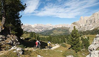
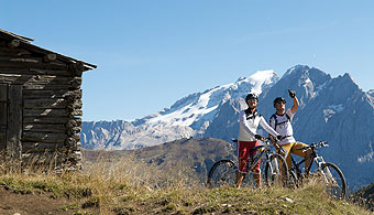
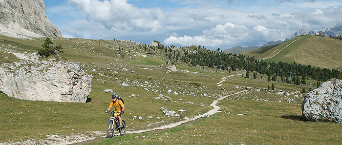
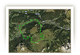
This short, in parts technically demanding tour leads through the “City of Stone” to the Salei Hut: thanks to the cable car to Ciampinoi, little climbing is required. Only real experts will be able to master some of the sections up to the City of Stone while remaining the saddle, but even pushing your bike for a few metres still allows you to admire the magnificent views of the Langkofel/Sassolungo towering above you. There are also two opportunities to get refreshments and appreciate the breathtaking panorama over the Dolomites, while a fantastic trail on the upper part of the descent also offers something to look forward to.
Just a short distance from the start of the tour near the Tourist Information Office in Wolkenstein/Selva is the bottom of the cable car to Ciampinoi, which takes you up the first 700m. From the top station a hiking trail initially leads steeply downhill then, after a climb, you arrive at the Comici Hut at the foot of the imposing Langkofel/Sassolungo. It is probably too soon to enjoy a refreshment stop, but the food on offer here is excellent. Perhaps you can have a quick drink and admire the panorama before continuing the tour. The path proceeds in the direction of the City of Stone, turning into a marvellous trail with some particularly steep sections and curves obliging most bikers to get off and push. An easy descent through the City of Stone takes you to the car park for the cable car up to the Langkofelscharte/Forcella del Sassolungo gorge, admiring the huge rocks that centuries before fell from the Langkofel/Sassolungo, silent witnesses of a bygone age.
A climb of 50m in the direction of Col Rodella brings you to the Salei Hut: as the tour is now mostly downhill, you can savour a long and enjoyable break.
Afterwards you return to the car park for the Langkofelscharte/Forcella del Sassolungo cable car, where the most interesting part of the tour begins in terms riding technique: a wonderful, narrow trail with a few tricky hairpin bends runs along the lower reaches of the City of Stone in the direction of Plan de Gralba before turning into a wide gravel path. From here, the trail is on the ski piste down to the Grödner Tal/Val Gardena, with the last section following the old railway line back to Wolkenstein/Selva.
|
| |
 |
| |
Variations
1. Omitting the Salei Hut: you can slightly shorten the tour by not turning sharp right towards the Salei Hut at the car park at the bottom of the Langkofelscharte/Forcella del Sassolungo cable car (waymarker 15) but instead bearing left downhill in the direction of Plan de Gralba. This omits waymarkers 15-20 (-1.5 km, -50m altitude).
2. Longer approach via Monte Pana: from the starting point in Wolkenstein/Selva, follow the “Sella Ronda anticlockwise” tour. Proceed towards Monte Pana via the village of La Selva then take the lift up to the top and from there to the Comici Hut. At waymarker 8 you rejoin the tour described above (+5.2 km, +310 m altitude). |
| |
|
| |
TOUR INFORMATION
Tour information |
|
% of distance |
Total distance |
14,32 km |
100 % |
Height variation uphill |
224 Hm |
|
Height variation downhill |
905 Hm |
|
Maximum altitude |
2247 m |
|
Tarmac |
0,52 km |
| 3,6 % |
 |
|
Tarmac cycle path |
1,67 km |
11,7 %
|
 |
|
Gravel |
4,80 km |
| 33,5 % |
 |
|
Hiking trail |
4,45 km |
31,1 %
|
 |
|
Single track |
1,01 km |
7,1 %
|
 |
|
Carrying / pushing |
0,06 km |
0,5 %
|
 |
|
Cable car / transfer |
1,79 km |
12,5 %
|
 |
|
|
| |
|
|
Riding times |
Riding time without pauses |
Riding time at 10 km/h |
1 hr 26 min |
Riding time at 12 km/h |
1 hr 12 min |
Riding time at 14 km/h |
1 hr 01 min |
Riding time at 16 km/h |
54 min |
Riding time at 18 km/h |
48 min |
Riding time at 20 km/h |
43 min |
| |
|
| |
|
| |
|
| |
|
| |
|
|
|
| |
|
Physical condition |
|
|
Overall condition |
2,2 |
|
Total height variation |
2,0 |
|
Total distance |
2,0 |
|
Maximum altitude |
4,0 |
|
|
|
Riding technique |
|
|
Overall riding technique |
3,7 |
|
Surface |
3,4 |
|
Average climb gradient Ø |
4,0 |
|
Average descent gradient Ø |
4,0 |
|
|
|
| |
|
Tour evaluation |
|
|
Overall difficulty |
2,9 |
|
Climb difficulty |
2,6 |
|
Descent difficulty |
3,5 |
|
|
|
Emotional experience |
|
|
Panorama |
5,0 |
|
Riding fun |
3,0 |
|
| |
|
|
|
|
| |
|
GETTING THERE AND STARTING POINT
Getting there
A22 motorway: coming from the north, take exit Innsbruck-Brennero; coming from the south, take exit Verona-Bolzano.
We recommend you exit the A22 at Klausen/Chiusa – Grödner Tal/Val Gardena: after 20 minutes on a well-signposted Alpine road you reach St. Ulrich/Ortisei then, after a few km, St. Christina/Santa Cristina and Wolkenstein/Selva.
Starting point
The tourist information office in Wolkenstein/Selva is located some 500 m after the entrance to the locality on the left.
Parking facilities: at the start of the centre of Wolkenstein/Selva, before the Piazza Nives, take two consecutive left turns to reach the car park of the same name.
The tour begins at the tourist information office in Wolkenstein/Selva. |
| |
ROADBOOK
No |
km |
Next |
Hm |
Sym |
Location |
Direction |
Route |
Time 22 km/h |
Time 10 km/h |
1 |
0,00 |
0,17 |
1557 |
|
Tourist information office in Wolkenstein/Selva |
Straight on uphill |
|
00:00 |
00:00 |
2 |
0,17 |
1,79 |
1566 |
|
Bottom of Ciampinoi lift |
Take cable car |
|
00:00 |
00:01 |
3 |
1,96 |
0,05 |
2247 |
|
Top of Ciampinoi lift and restaurant |
Right |
|
00:05 |
00:11 |
4 |
2,01 |
0,08 |
2244 |
|
Junction to ski piste Sasslonch |
Straight on |
|
00:05 |
00:12 |
5 |
2,08 |
0,57 |
2231 |
|
Top of chair lift |
Left to Comici Hut (path being rebuilt) |
|
00:05 |
00:12 |
6 |
2,66 |
0,47 |
2127 |
|
Tieja-Sattel (2.128m) |
Bear right to Sellajoch/Passo Sella, Naturonda |
|
00:07 |
00:15 |
7 |
3,13 |
0,22 |
2116 |
|
Junction to ski piste |
Straight on |
|
00:08 |
00:18 |
8 |
3,35 |
0,11 |
2137 |
|
Intersection near Comici Hut |
Left towards Comici Hut |
|
00:09 |
00:20 |
9 |
3,47 |
0,02 |
2153 |
|
Comici Hut |
Strait on to Passo Sella, City of Stone |
|
00:09 |
00:20 |
10 |
3,49 |
0,74 |
2152 |
|
Junction |
Straight on |
|
00:09 |
00:20 |
11 |
4,22 |
0,53 |
2148 |
|
Junction |
Bear right to City of Stone |
|
00:11 |
00:25 |
12 |
4,76 |
0,06 |
2226 |
|
Beginning of pushing section |
Straight on |
|
00:12 |
00:28 |
13 |
4,82 |
1,27 |
2235 |
|
End of pushing section |
Straight on |
|
00:13 |
00:28 |
14 |
6,09 |
0,06 |
2183 |
|
Bottom of Langkofelscharte gorge lift, end of City of Stone |
Straight on |
|
00:16 |
00:36 |
15 |
6,14 |
0,11 |
2181 |
|
Car park at bottom of Langkofelscharte gorge lift |
Sharp right uphill |
|
00:16 |
00:36 |
16 |
6,25 |
0,16 |
2190 |
|
Junction near chapel |
Straight on |
|
00:17 |
00:37 |
17 |
6,42 |
0,51 |
2212 |
|
Wayside cross |
Bear right to Salei Hut |
|
00:17 |
00:38 |
18 |
6,92 |
0,51 |
2224 |
|
Salei Hut |
Turn back |
|
00:18 |
00:41 |
19 |
7,43 |
0,16 |
2212 |
|
Crossroads (to Salei Hut) |
Bear left at meadow |
|
00:20 |
00:44 |
20 |
7,59 |
0,11 |
2190 |
|
Junction near chapel |
Straight on |
|
00:20 |
00:45 |
21 |
7,70 |
0,06 |
2181 |
|
Car park at bottom of Langkofelscharte gorge lift |
Straight on |
|
00:21 |
00:46 |
22 |
7,76 |
0,10 |
2180 |
|
Intersection with gravel road |
Right downhill |
|
00:21 |
00:46 |
23 |
7,87 |
0,49 |
2171 |
|
Crossroads by hut |
Straight on Plan de Gralba |
|
00:21 |
00:47 |
24 |
8,35 |
0,03 |
2113, |
|
Hut (fence) |
Straight on between hut and barn |
|
00:22 |
00:50 |
25 |
8,39 |
0,05 |
2111 |
|
Path junction |
Straight on over meadow |
|
00:22 |
00:50 |
26 |
8,44 |
0,53 |
2108 |
|
Crossroads |
Straight on |
|
00:23 |
00:50 |
27 |
8,97 |
0,63 |
2047 |
|
Crossroads |
Straight on |
|
00:24 |
00:53 |
28 |
9,60 |
0,60 |
1975 |
|
Intersection |
Bear right to Plan de Gralba, Wolkenstein/Selva |
|
00:26 |
00:57 |
29 |
10,20 |
0,69 |
1910 |
|
Wayside cross |
Follow main path |
|
00:27 |
01:01 |
30 |
10,90 |
0,27 |
1805 |
|
Junction to Jeuf de Frea (near bottom of drag lift) |
Straight on |
|
00:29 |
01:05 |
31 |
11,16 |
0,14 |
1787 |
|
Bridge over Rio Gardena stream |
Bear right over bridge |
|
00:30 |
01:06 |
32 |
11,31 |
0,15 |
1783 |
|
Bottom of the Piz Sella lift |
Left |
|
00:30 |
01:07 |
33 |
11,45 |
0,10 |
1781 |
|
Bridge over Plan de Gralba stream |
Left to Plan Wolkenstein/Selva (over bridge) |
|
00:31 |
01:08 |
34 |
11,55 |
0,06 |
1785 |
|
Covered snowgun |
Bear right to Wolkenstein/Selva |
|
00:31 |
01:09 |
35 |
11,61 |
0,79 |
1782 |
|
Junction at edge of forest |
Bear right downhill to Wolkenstein/Selva |
|
00:31 |
01:09 |
36 |
12,40 |
0,19 |
1621 |
|
Bridge over stream |
Bear right over bridge then along stream |
|
00:33 |
01:14 |
37 |
12,59 |
0,25 |
1604 |
|
Carpentry shop |
Straight on to Wolkenstein/Selva |
|
00:34 |
01:15 |
38 |
12,84 |
0,06 |
1589 |
|
Intersection with main road |
Sharp right to Plan de Gralba |
|
00:35 |
01:17 |
39 |
12,90 |
0,77 |
1593 |
|
Casa Alpina |
Bear left (left along sports ground) |
|
00:35 |
01:17 |
40 |
13,67 |
0,28 |
1581 |
|
Hotel La Tambra |
Bear right onto course of old railway |
|
00:37 |
01:22 |
41 |
13,94 |
0,09 |
1577 |
|
Hotel Sun Valley |
Sharp left downhill |
|
00:38 |
01:23 |
42 |
14,03 |
0,04 |
1567 |
|
Intersection with main road |
Sharp right |
|
00:38 |
01:24 |
43 |
14,07 |
0,09 |
1566 |
|
Hotel Krone |
Bear left following main road |
|
00:38 |
01:24 |
44 |
14,16 |
0,17 |
1566 |
|
Bottom of Ciampinoi lift |
Straight on |
|
00:38 |
01:24 |
45 |
14,32 |
0,00 |
1557 |
|
Tourist information office in Wolkenstein/Selva |
End of tour |
|
00:39 |
01:25 |
EXPLANATION OF EVALUATION FACTORS, SURFACE AND SLOPE
Explanation of evaluation factors
• Overall difficulty based on climb difficulty (60%) and descent difficulty (40%)
• Climb difficulty based on total distance uphill (30%), overall height variation uphill (30%), surface uphill (10%), average slope uphill (25%), highest altitude reached (5%).
• Descent difficulty consists of total distance downhill (10%), overall height variation downhill (10%), surface downhill (50%), average slope downhill (30%).
• Physical condition based on total distance (40%), with overall height variation (50%) and highest altitude reached (10%).
• Riding technique based on surface (50%), with average slope uphill (30%) and average slope downhill (20%).
• Writer’s subjective evaluation of panorama and riding fun.
Explanation of surface and slope |
|
|
|
A = Tarmac road |
|
steep uphil |
from + 15% |
R = Tarmac cycle path |
|
uphill |
up to + 14% |
S = Gravel |
|
level |
ca. +/- 4% |
W = Hiking trail |
|
downhill |
up to - 19% |
P = Path, Single Trail |
|
steep downhill |
from - 20% |
T = Carrying / pushing |
|
|
|
X = Cable car / transfer |
|
|
|
Route: the percentages indicate the average climb (+) or the average descent (-) to the next waymarker. |
DOWNLOADS
| |
 |
 |
 |
 |
CHARACTERISTICS |
ALTITUDE PROFILE |
ROADBOOK |
MAP |
|
| |
|