|
CHARACTERISTICS AND VARIATIONS
Characteristics
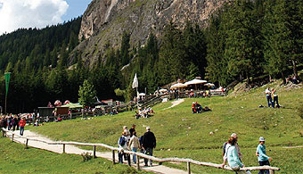
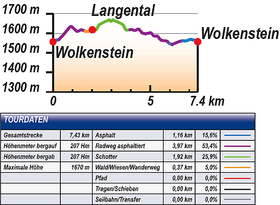
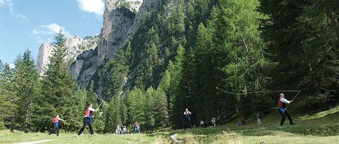
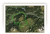
The Langental, to the north-east of Wolkenstein, is part of the Puez-Geisler nature park and impresses with its steeply towering rock faces on both sides and the beautiful head of the valley with the Pra da Ri mountain pasture. The toned-down version of the tour into the Langental is the ideal introductory tour for first-time mountain bikers or for families. It is toned-down because the tour does not go into the upper Langental, but only just as far as the mouth of the valley. The route follows side roads with little traffic and easy gravel and woodland trails.
From the start at the tourism association in Wolkenstein you go first of all to the valley station of Dantercepies. The route leads from there in a northerly direction, more downhill than uphill, until, at the mouth of the valley, you reach the car park with refreshment facilities.
The route suggested here only takes you about one kilometre and a good 50m in altitude difference into the Langental. Bikers, who find that this is not enough, can extend the tour as desired by following the cross-country ski route further uphill. It does not finish until the beginning of Pra da Ri mountain pasture. You cannot go further by bike (s. Variations). The way back takes you first of all to the car park again and then on the narrow access road down to the Langental and the cycle path west of Wolkenstein.
On this cycle path, once the railway line into the Gardena valley, you cycle gently uphill back to the starting point of the tour at the tourism association.
|
| |
 |
| |
Variations
1. Extension as far as Pra da Ri: Whoever would like to go further and higher, does not go back at the turning point of the tour in the lower Langental (waymarker 14), but follows the cross-country ski run further uphill as far as the Pra da Ri mountain pasture. There you can have a good rest. Return the same way, then continue the tour at waymarker 14 (+ 9.4km, +280m difference in altitude).
2. Combining with the Gardena valley tour: The tour into the Langental can be combined perfectly with the Gardena valley tour. The best way is to take the Gardena valley tour first of all as far as waymarker 61. Bear left there and follow the road for a short distance. At the next traffic roundabout go left and from there follow the road into the Langental. Join the tour described here at waymarker 23 and follow it in the opposite direction as far as waymarker 1 at the tourism association in Wolkenstein. |
| |
|
| |
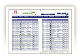
TOUR INFORMATION
Tour information |
|
% of distance |
Total distance |
7,43 km |
100 % |
Height variation uphill |
207 Hm |
|
Height variation downhill |
207 Hm |
|
Maximum altitude |
1670 m |
|
Tarmac |
1,16 km |
| 15,6 % |
 |
|
Tarmac cycle path |
3,97 km |
53,4 %
|
 |
|
Gravel |
1,92 km |
| 25,9 % |
 |
|
Hiking trail |
0,37 km |
5,0 %
|
 |
|
Single track |
0,00 km |
0,0 %
|
 |
|
Carrying / pushing |
0,00 km |
0,0 %
|
 |
|
Cable car / transfer |
0,00 km |
0,0 %
|
 |
|
|
| |
|
|
Riding times |
Riding time without pauses |
Riding time at 10 km/h |
45 min |
Riding time at 12 km/h |
37 min |
Riding time at 14 km/h |
32 min |
Riding time at 16 km/h |
28 min |
Riding time at 18 km/h |
25 min |
Riding time at 20 km/h |
22 min |
| |
|
| |
|
| |
|
| |
|
| |
|
|
|
| |
|
Physical condition |
|
|
Overall condition |
1,7 |
|
Total height variation |
2,0 |
|
Total distance |
1,0 |
|
Maximum altitude |
3,0 |
|
|
|
Riding technique |
|
|
Overall riding technique |
2,2 |
|
Surface |
2,4 |
|
Average climb gradient Ø |
2,0 |
|
Average descent gradient Ø |
2,0 |
|
|
|
| |
|
Tour evaluation |
|
|
Overall difficulty |
1,9 |
|
Climb difficulty |
1,8 |
|
Descent difficulty |
2,1 |
|
|
|
Emotional experience |
|
|
Panorama |
3,0 |
|
Riding fun |
2,0 |
|
| |
|
|
|
|
| |
|
GETTING THERE AND STARTING POINT
Getting there
Take Brenner motorway A22, coming from the north via Innsbruck-Brenner, or from the south via Verona-Bozen.
The best motorway exit is Klausen/Gröden. From there in about 20 minutes you can reach St Ulrich and a few kilometres further on St. Christina and Wolkenstein on a clearly signposted mountain road.
Starting point
The tourism association is located on the left about 500 m after you enter the village of Wolkenstein.
Parking is available at the the beginning of the village centre of Wolkenstein. Turn left before Nives Platz and then immediately left again into the Nives car park.
The tour begins at the tourism association Wolkenstein.
|
| |
ROADBOOK
No |
km |
Next |
Hm |
Sym |
Location |
Direction |
Route |
Time 22 km/h |
Time 10 km/h |
1 |
0,00 |
0,17 |
1557 |
|
Tourist information office in Wolkenstein/Selva |
Straight on uphill |
|
00:00 |
00:00 |
2 |
0,17 |
0,09 |
1566 |
|
Bottom of Ciampinoi lift |
Straight on |
|
00:00 |
00:01 |
3 |
0,25 |
0,04 |
1566 |
|
Hotel Krone |
Bear right onto main road |
|
00:00 |
00:01 |
4 |
0,29 |
0,09 |
1567 |
|
Junction with Str. Dantercepies |
Sharp left Langental/Vallunga |
|
00:00 |
00:01 |
5 |
0,38 |
0,16 |
1577 |
|
Hotel Sun Valley |
Straight on |
|
00:01 |
00:02 |
6 |
0,54 |
0,37 |
1593 |
|
Junction towards Langental/Vallunga |
Straight on to Dantercepies |
|
00:01 |
00:03 |
7 |
0,91 |
0,31 |
1635 |
|
Junction towards bottom of Dantercepies lift |
Bear left to Langental/Vallunga |
|
00:02 |
00:05 |
8 |
1,22 |
0,42 |
1610 |
|
Junction |
Bear right to Langental/Vallunga, cross-country ski trail |
|
00:03 |
00:07 |
9 |
1,65 |
0,37 |
1611 |
|
Ciampec Hut |
Right straight on to Langental/Vallunga |
|
00:04 |
00:09 |
10 |
2,02 |
0,02 |
1618 |
|
Imbiss La Ciajota snack-bar, car park |
Bear right (St. Silvester chapel) |
|
00:05 |
00:12 |
11 |
2,04 |
0,25 |
1618 |
|
Fork |
Bear left to Langental/Vallunga |
|
00:05 |
00:12 |
12 |
2,29 |
0,09 |
1629 |
|
Crossroads |
Straight on steep uphill |
|
00:06 |
00:13 |
13 |
2,38 |
0,60 |
1645 |
|
Crossroads straight on to fixed rope route |
Right to Langental/Vallunga, Puez Hut |
|
00:06 |
00:14 |
14 |
2,98 |
0,60 |
1661 |
|
Junction (large meadow) |
Turn back |
|
00:08 |
00:17 |
15 |
3,58 |
0,09 |
1645 |
|
Crossroads right to fixed rope route |
Left steep downhill |
|
00:09 |
00:21 |
16 |
3,67 |
0,25 |
1629 |
|
Crossroads |
Straight on downhill |
|
00:10 |
00:22 |
17 |
3,92 |
0,02 |
1618 |
|
Junction to St. Silvester chapel |
Bear right towards car park |
|
00:10 |
00:23 |
18 |
3,94 |
0,62 |
1618 |
|
Imbiss La Ciajota snack-bar, car park |
Bear right over car park (direction Wolkenstein/Selva) |
|
00:10 |
00:23 |
19 |
4,57 |
0,19 |
1602 |
|
Junction to café, snack-bar, VAL |
Bear right to Wolkenstein/Selva |
|
00:12 |
00:27 |
20 |
4,76 |
0,71 |
1597 |
|
Junction towards bottom of Dantercepies lift |
Straight on S. Cristina |
|
00:12 |
00:28 |
21 |
5,48 |
0,40 |
1572 |
|
Junction to Str. Larciunei |
Bear right to Str. Col da Lech |
|
00:14 |
00:32 |
22 |
5,87 |
0,02 |
1559 |
|
Haus Templa |
Straight on |
|
00:16 |
00:35 |
23 |
5,89 |
0,11 |
1557 |
|
Near Haus Templa |
Left |
|
00:16 |
00:35 |
24 |
6,00 |
0,12 |
1547 |
|
Intersection Strada Rainel |
Bear left |
|
00:16 |
00:35 |
25 |
6,12 |
0,48 |
1542 |
|
Hotel Sporting |
Bear left onto cycle path |
|
00:16 |
00:36 |
26 |
6,60 |
0,08 |
1561 |
|
End of cycle path |
Straight on |
|
00:17 |
00:39 |
27 |
6,68 |
0,10 |
1562 |
|
Villa Gran Baita |
Straight on |
|
00:18 |
00:40 |
28 |
6,79 |
0,29 |
1561 |
|
Wolkenstein/Selva primary school |
Straight on strada Nives |
|
00:18 |
00:40 |
29 |
7,07 |
0,11 |
1569 |
|
Pizzaealtro |
Bear right onto main road |
|
00:19 |
00:42 |
30 |
7,18 |
0,09 |
1566 |
|
Hotel Krone |
Sharp right |
|
00:19 |
00:43 |
31 |
7,27 |
0,17 |
1566 |
|
Bottom of Ciampinoi lift |
Straight on |
|
00:19 |
00:43 |
32 |
7,43 |
0,00 |
1557 |
|
Tourist information office in Wolkenstein/Selva |
End of tour |
|
00:20 |
00:44 |
EXPLANATION OF EVALUATION FACTORS, SURFACE AND SLOPE
Explanation of evaluation factors
• Overall difficulty based on climb difficulty (60%) and descent difficulty (40%)
• Climb difficulty based on total distance uphill (30%), overall height variation uphill (30%), surface uphill (10%), average slope uphill (25%), highest altitude reached (5%).
• Descent difficulty consists of total distance downhill (10%), overall height variation downhill (10%), surface downhill (50%), average slope downhill (30%).
• Physical condition based on total distance (40%), with overall height variation (50%) and highest altitude reached (10%).
• Riding technique based on surface (50%), with average slope uphill (30%) and average slope downhill (20%).
• Writer’s subjective evaluation of panorama and riding fun.
Explanation of surface and slope |
|
|
|
A = Tarmac road |
|
steep uphill |
from + 15% |
R = Tarmac cycle path |
|
uphill |
up to + 14% |
S = Gravel |
|
level |
ca. +/- 4% |
W = Hiking trail |
|
downhill |
up to - 19% |
P = Path, Single Trail |
|
steep downhill |
from - 20% |
T = Carrying / pushing |
|
|
|
X = Cable car / transfer |
|
|
|
Route: the percentages indicate the average climb (+) or the average descent (-) to the next waymarker. |
DOWNLOADS
| |
 |
 |
 |
 |
CHARACTERISTICS |
ALTITUDE PROFILE |
ROADBOOK |
MAP |
|
| |
|