|
CHARACTERISTICS AND VARIATIONS
Characteristics
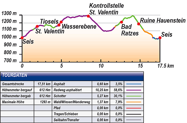
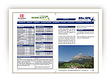
This is the ideal tour for newcomers to mountain biking. The 600m in altitude difference and the 17 kilometres to pass Castelvecchio does not present sporting novices with any difficulties. Apart from a few short sections the climbs are moderate and pass along easily ridable side or gravel roads. For practising riding technique there is a steeper descent on gravel to Castelvecchio and a flowing trail above Alpe di Siusi aerial cableway.
You can warm up easily in the first few kilometres from the tourism association Siusi to San Valentino. You continue at first still on tarmac with a splendid view of Castelrotto and then on gravel on the small hamlet of Tiosels.
The route climbs noticeably for the first time with an average 13% incline to the Wasserebene. This little tarmac road does not present any problems for mountain bike novices. The ascent continues to decrease behind the Wasserebene and, from the junction to the Schafstall onwards, a narrow side road, offering splendid views, climbs very gently to the control station San Valentino.
A short descent brings bikers back again in the direction of Siusi. Above the village you taxi along now under the Alpe di Siusi cable car through to Bagni di Razzes. The climb via Bagni di Razzes and onwards on the gravel road into the Wood of Castelvecchio can be ridden easily and is only a little ragged directly behind Bagni di Razzes.
Steeper terrain takes you above and past Castel Vecchio, tucked away in woodland. A steep gravel road will test your braking skill for the first time and after two switchbacks you arrive already at the junction for Castelvecchio that you can reach only on foot.
Once again in the saddle you first of all pass along a gravel road, but then on a very flowing trail to the car park of the Alpe di Siusi aerial cableway. From here you are only a few minutes away from the starting point of the tour at the tourism association in Siusi.
Variations
1. Short tour: Leaving out Tiosels and Wasserebene. Do not turn left at waymarker 4, but right in the direction of Bagni di Razzes (corresponds to waymarker 26). The tour is reduced by 9.4km and 290m difference in altitude.
2. Extension via Gstatsch: The tour becomes longer, but also above all technically more demanding, if you go uphill as far as Gstatsch (170m altitude difference) taking the Alpe di Siusi road at control station San Valentino (waymarker 22). On the last hairpin bend before the guesthouse turn right on a steep, narrow hiking trail leading to Bagni di Razzes. Cross the Frommer brook by bridge and follow the road that begins as gravel and so reach the road to Bagni di Razzes. You descend 120m and join the tour described here at waymarker 33 again at a bridge.
3. Extension via Schafstall and Marinzen: At waymarker 18 bear right uphill (at first very steep) to Schafstall and via Marinzen to Costazza (5km and 335m difference in altitude uphill). From there downhill as described in alternative 2.
|
| |
 |
| |
TOUR INFORMATION
Tour information |
|
% of distance |
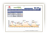
Total distance |
17,51 km |
100 % |
Height variation uphill |
612 Hm |
|
Height variation downhill |
612 Hm |
|
Maximum altitude |
1293 m |
|
Tarmac |
0,60 km |
| 3,5 % |
 |
|
Tarmac cycle path |
10,25 km |
58,6 %
|
 |
|
Gravel |
5,27 km |
| 30,1 % |
 |
|
Hiking trail |
1,37 km |
7,9 %
|
 |
|
Single track |
0,00 km |
0,0 %
|
 |
|
Carrying / pushing |
0,00 km |
0,0 %
|
 |
|
Cable car / transfer |
0,00 km |
0,0 %
|
 |
|
|
| |
|
|
Riding times |
Riding time without pauses |
Riding time at 10 km/h |
1 hr 45 min |
Riding time at 12 km/h |
1 hr 28 min |
Riding time at 14 km/h |
1 hr 15 min |
Riding time at 16 km/h |
1 hr 06 min |
Riding time at 18 km/h |
58 min |
Riding time at 20 km/h |
53 min |
| |
|
| |
|
| |
|
| |
|
| |
|
|
|
| |
|
Physical condition |
|
|
Overall condition |
2,5 |
|
Total height variation |
3,0 |
|
Total distance |
2,0 |
|
Maximum altitude |
2,0 |
|
|
|
Riding technique |
|
|
Overall riding technique |
2,7 |
|
Surface |
2,5 |
|
Average climb gradient Ø |
3,0 |
|
Average descent gradient Ø |
3,0 |
|
|
|
| |
|
Tour evaluation |
|
|
Overall difficulty |
2,6 |
|
Climb difficulty |
2,6 |
|
Descent difficulty |
2,7 |
|
|
|
Emotional experience |
|
|
Panorama |
3,0 |
|
Riding fun |
3,0 |
|
| |
|
|
|
|
| |
|
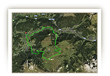
GETTING THERE AND STARTING POINT
Getting there
Coming from the north take the motorway (A22) exit for Chiusa – Alpe di Siusi/Sciliar, SS12 as far as Ponte Gardena, then in the direction of Alpe di Siusi.
Coming from the south take motorway (A22) exit for Bolzano Nord – Alpe di Siusi/Sciliar, SS12 as far as Prato all'Isarco, then in the direction of Alpe di Siusi.
Starting point
There are several car parks and underground parking facilities in all villages. Parking spaces marked in blue are subject to charges. Tickets are available from the appropriate automatic machines. All other parking spaces are free of charge.
The tour begins at the tourism association Siusi.
|
| |
ROADBOOK
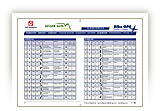
No |
km |
Next |
Hm |
Sym |
Location |
Direction |
Route |
Time 22 km/h |
Time 10 km/h |
1 |
0,00 |
0,03 |
1010 |
|
Tourism association Siusi, bus station |
Straight ahead |
|
00:00 |
00:00 |
2 |
0,03 |
0,57 |
1017 |
|
Junction |
Right Henrik-Ibsen- Str. |
|
00:00 |
00:00 |
3 |
0,60 |
0,38 |
1054 |
|
Junction with Via Fasslfun |
Bear right uphill |
|
00:01 |
00:03 |
4 |
0,99 |
0,16 |
1095 |
|
Crossroad |
LLeft Castelrotto (Castelrotto) 6 |
|
00:02 |
00:05 |
5 |
1,15 |
0,27 |
1105 |
|
Junction |
Bear Left Castelrotto (Castelrotto) 6 |
|
00:03 |
00:06 |
6 |
1,42 |
0,26 |
1115 |
|
Private car park |
Straight ahead |
|
00:03 |
00:08 |
7 |
1,68 |
0,25 |
1134 |
|
Patener Hof |
Bear right Kastelruth (Castelrotto) 6 |
|
00:04 |
00:10 |
8 |
1,93 |
0,08 |
1155 |
|
Intersection Alpe di Siusi road in San Valentino |
Sharp right uphill |
|
00:05 |
00:11 |
9 |
2,01 |
0,12 |
1159 |
|
Junction |
Left Maso Psoar-Hof |
|
00:05 |
00:12 |
10 |
2,13 |
0,70 |
1160 |
|
Maso Psoar-Hof |
Bear right Kastelruth (Castelrotto) 6 |
|
00:05 |
00:12 |
11 |
2,83 |
0,26 |
1159 |
|
Crossroad |
Right Tiosels 7 |
|
00:07 |
00:16 |
12 |
3,09 |
0,88 |
1178 |
|
Junction |
Straight ahead Tiosels 7 |
|
00:08 |
00:18 |
13 |
3,97 |
0,30 |
1137 |
|
Junction |
Straight ahead St. Michael 7 |
|
00:10 |
00:23 |
14 |
4,27 |
0,06 |
1155 |
|
Intersection |
Bear left St. Michael 7 |
|
00:11 |
00:25 |
15 |
4,32 |
0,35 |
1155 |
|
Intersection |
Straight ahead St. Michael 7 |
|
00:11 |
00:25 |
16 |
4,68 |
0,28 |
1173 |
|
Hof Unterdill in Tiosels |
Bear right Wasserebene, St. Michael 7 |
|
00:12 |
00:28 |
17 |
4,96 |
0,80 |
1211 |
|
Crossroad sports ground Wasserebene |
Straight ahead uphill Schafstall 8 |
|
00:13 |
00:29 |
18 |
5,76 |
0,12 |
1277 |
|
Turn-off for Schafstall |
Straight ahead |
|
00:15 |
00:34 |
19 |
5,88 |
1,42 |
1277 |
|
Turn-off for Schafstall |
Straight ahead |
|
00:16 |
00:35 |
20 |
7,30 |
0,60 |
1291 |
|
Crossroad |
Straight ahead |
|
00:19 |
00:43 |
21 |
7,90 |
0,51 |
1288 |
|
Turn-off for Marinzen |
Straight ahead Alpe di Siusi, Siusi |
|
00:21 |
00:47 |
22 |
8,41 |
0,57 |
1286 |
|
Control position San Valentino |
Sharp right Seis (Siusi) 4 |
|
00:22 |
00:50 |
23 |
8,98 |
1,10 |
1231 |
|
Haus Waldrand, bus stop |
Sharp left Trotzstr. |
|
00:24 |
00:53 |
24 |
10,08 |
0,17 |
1121 |
|
Junction with Via Burgstall |
Straight ahead downhill |
|
00:27 |
01:00 |
25 |
10,25 |
0,16 |
1105 |
|
Turn-off for Kastelruth (Castelrotto) 6 |
Bear Left Bagni di Razzes 6 |
|
00:27 |
01:01 |
26 |
10,41 |
0,54 |
1095 |
|
Crossroads Way of the cross |
Straight ahead Bad Ratzes |
|
00:28 |
01:02 |
27 |
10,95 |
0,33 |
1097 |
|
Junction for Bad Ratzes (Bagni di Razzes) 6 |
Bear right level road |
|
00:29 |
01:05 |
28 |
11,28 |
0,11 |
1102 |
|
Wooden bridge |
Left Bad Ratzes |
|
00:30 |
01:07 |
29 |
11,39 |
0,40 |
1109 |
|
Turn-off for Siusi aerial cableway |
Straight ahead uphill |
|
00:31 |
01:08 |
30 |
11,79 |
0,13 |
1148 |
|
Junction |
Bear right uphill |
|
00:32 |
01:10 |
31 |
11,93 |
0,09 |
1165 |
|
Water reservoir |
Bear left |
|
00:32 |
01:11 |
32 |
12,02 |
0,05 |
1167 |
|
Intersection |
Bear right uphill |
|
00:32 |
01:12 |
33 |
12,07 |
0,15 |
1167 |
|
Bridge over brook |
Bear right uphill |
|
00:32 |
01:12 |
34 |
12,22 |
0,42 |
1177 |
|
Turn-off for Castelvecchio |
Straight ahead Schlernbödele- Malghetta Sciliar 3B |
|
00:33 |
01:13 |
35 |
12,64 |
0,08 |
1210 |
|
Crossroads near to Bagni di Razzes |
Bear right uphill Schlern (Sciliar) 1 |
|
00:34 |
01:15 |
36 |
17,72 |
1,05 |
1220 |
|
Junction to Schlern (Sciliar) 1 |
Sharp right Bischofsweg |
|
00:34 |
01:16 |
37 |
13,77 |
0,48 |
1273 |
|
Fountain |
Straight ahead |
|
00:37 |
01:22 |
38 |
14,24 |
0,39 |
1281 |
|
Junction |
Sharp right Castelvecchio |
|
00:38 |
01:25 |
39 |
14,63 |
0,18 |
121 |
|
Junction gravel road |
Straight ahead downhill |
|
00:39 |
01:27 |
40 |
14,81 |
0,14 |
1187 |
|
Crossroad Castelvecchio |
Straight ahead |
|
00:40 |
01:28 |
41 |
14,95 |
0,43 |
1179 |
|
Fountain |
Straight ahead downhill Seis |
|
00:40 |
01:29 |
42 |
15,38 |
0,25 |
1117 |
|
Crossroad |
Sharp left Ruine Salegg (Castel Seligo) 3 |
|
00:41 |
01:32 |
43 |
15,64 |
0,68 |
1086 |
|
Plaque on life expectancy |
Straight ahead |
|
00:42 |
01:33 |
44 |
16,32 |
0,31 |
1060 |
|
Crossroad |
Sharp right downhill (later 3B) |
|
00:44 |
01:37 |
45 |
16,63 |
0,07 |
1012 |
|
Car park Alpe di Siusi cable car |
Bear right across the car park |
|
00:45 |
01:39 |
46 |
16,70 |
0,15 |
1012 |
|
Valley station Alpe di Siusi aerial cableway |
Sharp left |
|
00:45 |
01:40 |
47 |
16,85 |
0,13 |
1004 |
|
Junction Via Oswald von Wolkenstein |
Right downhill |
|
00:45 |
01:41 |
48 |
16,97 |
0,11 |
995 |
|
Bridge over brook, entrance car park Alpe di Siusi aerial cableway |
Straight ahead over bridge |
|
00:46 |
01:41 |
49 |
17,08 |
0,11 |
999 |
|
Junction private road |
Bear left Siusi |
|
00:46 |
01:42 |
50 |
17,19 |
0,02 |
995 |
|
Crossroad Matzlstr. |
Bear left to main road |
|
00:46 |
01:43 |
51 |
17,22 |
0,24 |
995 |
|
Garni Hauenstein |
Right |
|
00:46 |
01:43 |
52 |
17,45 |
0,06 |
1006 |
|
Traffic roundabout Siusi |
Straight ahead Kastelruth |
|
00:47 |
01:44 |
53 |
17,52 |
0,00 |
1010 |
|
Tourism association Siusi, bus stop |
End of tour |
|
00:47 |
01:45 |
EXPLANATION OF EVALUATION FACTORS, SURFACE AND SLOPE
Explanation of evaluation factors
• Overall difficulty based on climb difficulty (60%) and descent difficulty (40%)
• Climb difficulty based on total distance uphill (30%), overall height variation uphill (30%), surface uphill (10%), average slope uphill (25%), highest altitude reached (5%).
• Descent difficulty consists of total distance downhill (10%), overall height variation downhill (10%), surface downhill (50%), average slope downhill (30%).
• Physical condition based on total distance (40%), with overall height variation (50%) and highest altitude reached (10%).
• Riding technique based on surface (50%), with average slope uphill (30%) and average slope downhill (20%).
• Writer’s subjective evaluation of panorama and riding fun.
Explanation of surface and slope |
|
|
|
A = Tarmac road |
|
steep uphill |
from + 15% |
R = Tarmac cycle path |
|
uphill |
up to + 14% |
S = Gravel |
|
level |
ca. +/- 4% |
W = Hiking trail |
|
downhill |
up to - 19% |
P = Path, Single Trail |
|
steep downhill |
from - 20% |
T = Carrying / pushing |
|
|
|
X = Cable car / transfer |
|
|
|
Route: the percentages indicate the average climb (+) or the average descent (-) to the next waymarker. |
DOWNLOADS
| |
 |
 |
 |
 |
CHARACTERISTICS |
ALTITUDE PROFILE |
ROADBOOK |
MAP |
|
| |
|