|
CHARACTERISTICS AND VARIATIONS
Characteristics
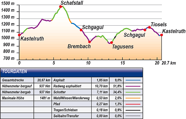
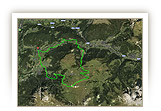
The best way to describe this short, varied tour is that you can burn up energy on the way up to Schafstall, cool off on the way down to Brembach, two mountain sprints ahead Tagusa and the Tiosler pond. You finish off by casual coasting down via Schagul and Tiosels back to Castelrotto.
The tour starts from the tower in the picturesque centre of Castelrotto and then first of all in the direction of San Valentino on the Alpe di Siusi road. The first two kilometres only climb gently and are ideally suited for warming up.
A first steeper incline leads high up to the road leading to Wasserebene and offers stunning views. You follow this as far as the turn-off leading to Stalla delle Pecore.
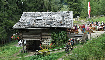
The climb to Schafstall falls into the category “no mercy for your calves”. The 200m difference in altitude is demanding. The average climb reaches 20%. Fortunately, refreshments are waiting for you up at the Schafstall where you can slake your thirst and cool off.
There follows a short, crisp woodland trail that later merges into a gravel road that goes ever steeper downhill. Take care not to miss the turn-off onto hiking trail no. 9 (waymarker 18) as you descend! This hiking trail joins San Michele on the main road that you follow turning left in the direction of Castelrotto as far as Schagul.
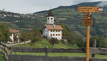
The continuing descent along the Brembach (brook) is cool and shady. Mountain sprint no. 1 begins here. You climb on tarmac high up to the Maso Tamines Hof. The route continues on the gravel road to Tagusa, a small hamlet whose distinctive church overlooks the Val Gardena.
The somewhat longer mountain sprint no. 2 begins in Tagusa, once again a good 200m in altitude difference through the Tagusa woodland past the Tiosler pond. That was it! The rest of the loop goes back to Schgagul in a series of easy climbs and descents. With a last short climb over the side road to Tiosels you again reach the centre of Castelrotto.
Variations
1. Leaving out Schafstall: Whoever would like to avoid the steep climb to the Schafstall should continue straight ahead at waymarker 10 and cruise via Wasserebene to Tiosels. Turn right there in the direction of the main road, where you join the tour described here at waymarker 23.
2. Via Tisana to Castelrotto: Do not turn sharp left in Tagusa at waymarker 33, but bear left in the direction of Tisana. Then go left uphill and right at the Maso Ganserhof. 260m further on the hiking trail bears left back to Castelrotto.
3. Long training tour over the Alpe di Siusi: At waymarker 14 at the Schafstall turn sharp right towards Marinzen. Continue via Gstatsch and the Alpe di Siusi road to Compaccio. Go straight ahead there towards Saltria and via Monte Piz, Bulla and the Passo Pinei to San Michele. There you join the tour described here at waymarker 21 (20.7km and 654m difference in altitude uphill from the Schafstall to San Michele).
|
| |
|
| |
TOUR INFORMATION
Tour information |
|
% of distance |
Total distance |
20,67 km |
100 % |
Height variation uphill |
937 Hm |
|
Height variation downhill |
937 Hm |
|
Maximum altitude |
1481 m |
|
Tarmac |
1,85 km |
| 9,0 % |
 |
|
Tarmac cycle path |
10,70 km |
51,8 %
|
 |
|
Gravel |
7,11 km |
| 34,4 % |
 |
|
Hiking trail |
0,53 km |
2,6%
|
 |
|
Single track |
0,27 km |
1,3 %
|
 |
|
Carrying / pushing |
0,18 km |
0,9 %
|
 |
|
Cable car / transfer |
0,00 km |
0,0 %
|
 |
|
|
| |
|
|
Riding times |
Riding time without pauses |
Riding time at 10 km/h |
2 hrs 04 min |
Riding time at 12 km/h |
1 hr 43 min |
Riding time at 14 km/h |
1 hr 29 min |
Riding time at 16 km/h |
1 hr 18 min |
Riding time at 18 km/h |
1 hr 09 min |
Riding time at 20 km/h |
1 hr 02 min |
| |
|
| |
|
| |
|
| |
|
| |
|
|
|
| |
|
Physical condition |
|
|
Overall condition |
2,9 |
|
Total height variation |
3,0 |
|
Total distance |
3,0 |
|
Maximum altitude |
2,0 |
|
|
|
Riding technique |
|
|
Overall riding technique |
3,1 |
|
Surface |
2,7 |
|
Average climb gradient Ø |
4,0 |
|
Average descent gradient Ø |
3,0 |
|
|
|
| |
|
Tour evaluation |
|
|
Overall difficulty |
3,0 |
|
Climb difficulty |
3,2 |
|
Descent difficulty |
2,7 |
|
|
|
Emotional experience |
|
|
Panorama |
3,0 |
|
Riding fun |
3,0 |
|
| |
|
|
|
|
| |
|
GETTING THERE AND STARTING POINT
Getting there
Coming from the north take the motorway (A22) exit for Chiusa – Alpe di Siusi/Sciliar, SS12 as far as Ponte Gardena, then in the direction of Alpe di Siusi.
Coming from the south take motorway (A22) exit for Bolzano Nord – Alpe di Siusi/Sciliar, SS12 as far as Prato all'Isarco, then in the direction of Alpe di Siusi.
Starting point
There are several car parks and underground parking facilities in all villages. Parking spaces marked in blue are subject to charges. Tickets are available from the appropriate automatic machines. All other parking spaces are free of charge.
The tour begins at the tourism association in Castelrotto. |
| |
ROADBOOK
No |
km |
Next |
Hm |
Sym |
Location |
Direction |
Route |
Time 22 km/h |
Time 10 km/h |
1 |
0,00 |
0,07 |
1062 |
|
Tourism association Castelrotto |
Straight ahead between Castelrotto tower and fountain |
|
00:00 |
00:00 |
2 |
0,07 |
0,06 |
1059 |
|
Hotel zum Wolf |
Bear right |
|
00:00 |
00:00 |
3 |
0,13 |
0,47 |
1061 |
|
Sparkasse Kastelruth |
Straight Marinzenweg |
|
00:00 |
00:00 |
4 |
0,60 |
0,74 |
1098 |
|
Turn-off to Telfen 6A |
Bear left Seis (Siusi) 6 |
|
00:01 |
00:03 |
5 |
1,34 |
0,70 |
1159 |
|
Crossroad |
Straight ahead Seis (Siusi) 6 |
|
00:03 |
00:08 |
6 |
2,04 |
0,12 |
1160 |
|
Maso Psoar-Hof |
Bear left |
|
00:05 |
00:12 |
7 |
2,16 |
0,49 |
1159 |
|
Intersection Alpe di Siusi road |
Left uphill |
|
00:05 |
00:12 |
8 |
2,65 |
0,65 |
1194 |
|
Maso Schildberghof |
Left uphill |
|
00:07 |
00:15 |
9 |
3,31 |
1,42 |
1291 |
|
Crossroad |
Left Castelrotto |
|
00:09 |
00:19 |
10 |
4,73 |
0,09 |
1277 |
|
Junction |
Bear right uphill Marinzen mountain cabin |
|
00:12 |
00:28 |
11 |
4,82 |
0,65 |
1292 |
|
Junction |
Straight ahead |
|
00:13 |
00:28 |
12 |
5,47 |
0,21 |
1382 |
|
Turn-off to the Wasserebene |
Straight ahead Schafstall 8 |
|
00:14 |
00:32 |
13 |
5,68 |
0,31 |
1424 |
|
Junction |
Straight ahead uphill Schafstall 8 |
|
00:15 |
00:34 |
14 |
5,99 |
0,04 |
1476 |
|
Schafstall |
Straight ahead past Schafstall |
|
00:16 |
00:35 |
15 |
6,03 |
0,03 |
1479 |
|
Intersection behind Schafstall |
Right St. Michael (San Michele) 9 |
|
00:16 |
00:36 |
16 |
6,06 |
0,28 |
1481 |
|
Turn-off to Bullaccia |
Bear left downhill St. Michael (San Michele) 9 |
|
00:16 |
00:36 |
17 |
6,34 |
0,90 |
1479 |
|
Intersection gravel road |
Straight ahead steeply downhill |
|
00:17 |
00:38 |
18 |
7,24 |
0,12 |
1298 |
|
Junction |
Bear left downhill hiking trail 9 |
|
00:19 |
00:43 |
19 |
7,36 |
0,09 |
1268 |
|
Bench at cabin |
Bear Left Castelrotto 7 |
|
00:20 |
00:44 |
20 |
7,45 |
0,16 |
1256 |
|
Fork near farmstead |
Bear right downhill bar/restaurant |
|
00:20 |
00:44 |
21 |
7,61 |
0,90 |
1232 |
|
Maso Ritsch Hof in San Michele |
Left |
|
00:20 |
00:45 |
22 |
8,51 |
0,17 |
1177 |
|
Junction to Wasserebene |
Straight ahead downhill |
|
00:23 |
00:51 |
23 |
8,68 |
0,30 |
1165 |
|
Junction Tioslerweg, to sports cabin |
Straight ahead downhill |
|
00:23 |
00:52 |
24 |
8,97 |
0,06 |
1136 |
|
To Schgagul / snack bar Sabine |
Right Maso Radauerhof, Maso Dosserhof |
|
00:24 |
00:53 |
25 |
9,03 |
0,07 |
1133 |
|
Fork |
Bear right St. Michael (San Michele) 10 |
|
00:24 |
00:54 |
26 |
9,10 |
1,11 |
1130 |
|
Fork |
Bear left Tagusens (Tagusa) 2A |
|
00:24 |
00:54 |
27 |
10,21 |
1,04 |
962 |
|
Junction to Brembach 5 |
Straight ahead Tagusa 2A |
|
00:27 |
01:01 |
28 |
11,25 |
1,19 |
1036 |
|
Maso Tamines Hof |
Left Tagusa 2 |
|
00:30 |
01:07 |
29 |
12,43 |
0,22 |
1013 |
|
Junction |
Straight ahead |
|
00:33 |
01:14 |
30 |
12,66 |
0,10 |
991 |
|
Intersection |
Bear left |
|
00:34 |
01:15 |
31 |
12,76 |
0,12 |
985 |
|
Junction |
Bear right downhill Tagusa 2 |
|
00:34 |
01:16 |
32 |
12,88 |
0,53 |
961 |
|
Maso Neuhauserhof |
Straight ahead |
|
00:35 |
01:17 |
33 |
13,41 |
0,10 |
951 |
|
Tagusa (fountain) |
Sharp left Castelrotto 2 |
|
00:36 |
01:20 |
34 |
13,50 |
0,27 |
963 |
|
End of tarmac |
Straight ahead |
|
00:36 |
01:21 |
35 |
13,77 |
0,07 |
1010 |
|
Wayside cross |
Bear right uphill |
|
00:7 |
01:22 |
36 |
13,85 |
0,19 |
1017 |
|
Crossroads tarmac road |
Straight ahead uphill hiking trail |
|
00:37 |
01:23 |
37 |
14,04 |
0,29 |
1048 |
|
End of pushing bike |
Straight ahead |
|
00:38 |
01:24 |
38 |
14,32 |
0,17 |
1082 |
|
Junction to Tagusens (Tagusa) 2 |
Straight ahead Kastelruth (Castelrotto) 2 |
|
00:39 |
01:25 |
39 |
14,49 |
0,44 |
1090 |
|
Junction |
Straight ahead |
|
00:39 |
01:26 |
40 |
14,93 |
0,10 |
1124 |
|
Crossroad |
Bear Left Castelrotto 2a |
|
00:40 |
01:29 |
41 |
15,03 |
0,23 |
1128 |
|
Fishing pond |
Straight ahead |
|
00:40 |
01:30 |
42 |
15,27 |
0,39 |
1150 |
|
Alter Hof |
Sharp right Kastelruth (Castelrotto) 2a |
|
00:41 |
01:31 |
43 |
15,66 |
0,70 |
1156 |
|
Wayside cross, bench |
Straight ahead |
|
00:42 |
01:33 |
44 |
16,36 |
1,22 |
1119 |
|
Junction to Castelrotto |
Straight ahead St. Michael 2a |
|
00:44 |
01:38 |
45 |
17,58 |
0,47 |
1136 |
|
Letter box |
Right |
|
00:47 |
01:45 |
46 |
18,06 |
0,14 |
1141 |
|
Junction to Castelrotto 10 |
Straight ahead St. Michael 10 |
|
00:49 |
01:48 |
47 |
18,20 |
0,06 |
1133 |
|
Junction |
Bear right |
|
00:49 |
01:49 |
48 |
18,26 |
0,30 |
1136 |
|
To Schgagul / snack bar Sabine |
Left uphill |
|
00:49 |
01:49 |
49 |
18,55 |
0,36 |
1165 |
|
Junction, bus stop |
Right Tioslerweg, sports cabin |
|
00:50 |
01:51 |
50 |
18,92 |
0,35 |
1173 |
|
Maso Hof Unterdill in Tiosels |
Straight ahead Seis (Siusi) 7 |
|
00:51 |
01:53 |
51 |
19,27 |
0,29 |
1155 |
|
Turn-off to Seis (Siusi) 7 |
Bear right downhill |
|
00:52 |
01:55 |
52 |
19,57 |
0,78 |
1121 |
|
Turn-off to St. Michael (San Michele) 7 |
Bear right downhill |
|
00:53 |
01:57 |
53 |
20,35 |
0,20 |
1052 |
|
Konsum-Markt |
Bear left |
|
00:55 |
02:02 |
54 |
20,55 |
0,06 |
1061 |
|
Sparkasse Kastelruth |
Right centre |
|
00:56 |
02:03 |
55 |
20,60 |
0,07 |
1059 |
|
Hotel zum Wolf |
Bear left |
|
00:56 |
02:03 |
56 |
20,68 |
0,00 |
1062 |
|
Tourism association Castelrotto |
End of tour |
|
00:56 |
02:04 |
EXPLANATION OF EVALUATION FACTORS, SURFACE AND SLOPE
Explanation of evaluation factors
• Overall difficulty based on climb difficulty (60%) and descent difficulty (40%)
• Climb difficulty based on total distance uphill (30%), overall height variation uphill (30%), surface uphill (10%), average slope uphill (25%), highest altitude reached (5%).
• Descent difficulty consists of total distance downhill (10%), overall height variation downhill (10%), surface downhill (50%), average slope downhill (30%).
• Physical condition based on total distance (40%), with overall height variation (50%) and highest altitude reached (10%).
• Riding technique based on surface (50%), with average slope uphill (30%) and average slope downhill (20%).
• Writer’s subjective evaluation of panorama and riding fun.
Explanation of surface and slope |
|
|
|
A = Tarmac road |
|
steep uphill |
from + 15% |
R = Tarmac cycle path |
|
uphill |
up to + 14% |
S = Gravel |
|
level |
ca. +/- 4% |
W = Hiking trail |
|
downhill |
up to - 19% |
P = Path, Single Trail |
|
steep downhill |
from - 20% |
T = Carrying / pushing |
|
|
|
X = Cable car / transfer |
|
|
|
Route: the percentages indicate the average climb (+) or the average descent (-) to the next waymarker. |
DOWNLOADS
| |
 |
 |
 |
 |
CHARACTERISTICS |
ALTITUDE PROFILE |
ROADBOOK |
MAP |
|
| |
|