|
CHARACTERISTICS AND VARIATIONS
Characteristics
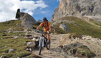
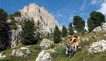
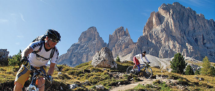
The Sellajoch with its staggering panorama of the Dolomite Mountains and the rocky ruins of the stony town at the foot of the Langkofel are magical points of attraction for skiers, hikers and mountain bikers. Whoever has worked his way up with his own muscular strength from the Gardena valley, experiences this particularly intensively. The ascent in the upper part shortly before the stony town is easy, even if momentarily steep. The way through the stony town as far as the Rifugio (mountain cabin) Comici offers a lot of fun on the trails directly below the mighty Langkofel. The Rifugio Comici is an appropriate place for refreshments where even gourmets will get their money's worth. The long and varied descent back to Wolkenstein is a short but very worthwhile end to this tour.
From the tourism association in Wolkenstein you can warm up perfectly on the gently rising former railway line. Then for just under 2.5km you follow the pass road that has more traffic in the season as far as Plan de Gralba. Here there is no realistic alternative for mountain bikers. But the less than 200m difference in altitude are soon completed and from Plan de Gralba it becomes noticeably steeper uphill still heading for Sellajoch. At first, the way leads over a gravel path, but changes in the upper part to a fantastic narrow trail with some narrow switchbacks. Here you can already see the outskirts of the stony town. Fit bikers with a good technique will be able to do everything. Those who want to or have to dismount can enjoy here already the impressive view of the steeply towering Langkofel.
The path still gently rising through the midst of the stony town begins from the car park of the cable car to the Langkofelscharte. In the season and on fine weekends, you are bound to share this section with many other hikers and bikers. That does not matter. You should go slowly here anyway and marvel at the stony witnesses of several centuries of rock-slides of the Langkofel in its various forms.
The following descent begins with a supertrail in the shade of the Langkofel. You could continue on this, but the Rifugio Comici is located one and a half kilometres further on on the edge of the trail, a refreshment stop that bikers find difficult to ride past. You may find it difficult to believe, but you can eat excellently in this stunningly located mountain cabin. It remains a secret from where the innkeeper gets the fresh fish for which he is, among other things, highly renowned. In any case, in accordance with all the rules of the culinary art, gourmets can let themselves be pampered here.
It is good that the rest of the way to Wolkenstein is now almost only downhill because a full stomach adds speed to the journey down to the valley. But take care! This varied descent branches off into a hardly-noticeable track that you are guaranteed to rush past if you do not look closely at the road book or GPS equipment (waymarker 36).
Somewhat surprisingly you climb yet again uphill 50m in altitude before La Selva, then however you roll along relaxed and happy back to the starting point of the tour in Wolkenstein.
|
| |
 |
| |
Variations
1. Ascent with the cable car: You will not see the Sellajoch and the stony town on this alternative route, but in Wolkenstein you can also take the cable car to Ciampinoi and from the mountain station follow the signposts to Comici. You join the tour described here at waymarker 30 right next to the refreshment station.
2. Extension via Monte Pana: Do not turn sharp right at the easily overlooked waymarker 36, but go straight ahead on the gravel road. After exactly two kilometres, turn sharp right in the direction of Monte Pana. Continue downhill and take the beautiful trail to Cislat and La Selva. There you join the tour described here at waymarker 46.
3. Complete ascent to the mountain pass road: The ascent from Plan de Gralba as far as the car park of the cable car to Langkofelscharte on the mountain pass to Sellajoch is conceivable, but only to be recommended when there is light traffic. To do this in Plan de Gralba at waymarker 10 continue uphill straight ahead on the main road. The car park for the cable car is located on the right shortly before you reach the Sellajoch. You can continue the tour described here at waymarker 23. |
| |
|
| |
TOUR INFORMATION
Tour information |
|
% of distance |
Total distance |
17,91 km |
100 % |
Height variation uphill |
805 Hm |
|
Height variation downhill |
805 Hm |
|
Maximum altitude |
2245 m |
|
Tarmac |
2,73 km |
| 15,3 % |
 |
|
Tarmac cycle path |
3,11 km |
17,4 %
|
 |
|
Gravel |
7,88 km |
| 44,0 % |
 |
|
Hiking trail |
2,96 km |
16,6 %
|
 |
|
Single track |
1,21 km |
6,8 %
|
 |
|
Carrying / pushing |
0,00 km |
0,0 %
|
 |
|
Cable car / transfer |
0,00 km |
0,0 %
|
 |
|
|
| |
|
|
Riding times |
Riding time without pauses |
Riding time at 10 km/h |
1 hr 47 min |
Riding time at 12 km/h |
1 hr 30 min |
Riding time at 14 km/h |
1 hr 17 min |
Riding time at 16 km/h |
1 hr 07 min |
Riding time at 18 km/h |
1 hr 00 min |
Riding time at 20 km/h |
54 min |
| |
|
| |
|
| |
|
| |
|
| |
|
|
|
| |
|
Physical condition |
|
|
Overall condition |
2,7 |
|
Total height variation |
3,0 |
|
Total distance |
2,0 |
|
Maximum altitude |
4,0 |
|
|
|
Riding technique |
|
|
Overall riding technique |
3,6 |
|
Surface |
3,3 |
|
Average climb gradient Ø |
4,0 |
|
Average descent gradient Ø |
4,0 |
|
|
|
| |
|
Tour evaluation |
|
|
Overall difficulty |
3,8 |
|
Climb difficulty |
4,0 |
|
Descent difficulty |
3,6 |
|
|
|
Emotional experience |
|
|
Panorama |
5,0 |
|
Riding fun |
4,0 |
|
| |
|
|
|
|
| |
|
GETTING THERE AND STARTING POINT
Getting there
Take Brenner motorway A22, coming from the north via Innsbruck-Brenner, or from the south via Verona-Bozen.
The best motorway exit is Klausen/Gröden. From there in about 20 minutes you can reach St Ulrich and a few kilometres further on St. Christina and Wolkenstein on a clearly signposted mountain road.
Starting point
The tourism association is located on the left about 500 m after you enter the village of Wolkenstein.
Parking is available at the the beginning of the village centre of Wolkenstein. Turn left before Nives Platz and then immediately left again into the Nives car park.
The tour begins at the tourism association Wolkenstein.
|
| |
ROADBOOK
No |
km |
Next |
Hm |
Sym |
Location |
Direction |
Route |
Time 22 km/h |
Time 10 km/h |
1 |
0,00 |
0,17 |
1557 |
|
Tourist information office in Wolkenstein/Selva |
Straight on uphill |
|
00:00 |
00:00 |
2 |
0,17 |
0,09 |
1566 |
|
Bottom of Ciampinoi lift |
Straight on |
|
00:00 |
00:01 |
3 |
0,25 |
0,04 |
1566 |
|
Hotel Krone |
Bear right onto main road |
|
00:00 |
00:01 |
4 |
0,29 |
0,09 |
1567 |
|
Junction with Str. Dantercepies |
Sharp left Langental/Vallunga |
|
00:00 |
00:01 |
5 |
0,38 |
0,28 |
1577 |
|
Hotel Sun Valley |
Sharp right onto course of old railway |
|
00:01 |
00:02 |
6 |
0,65 |
0,77 |
1581 |
|
Hotel La Tambra |
Bear left on course of old railway |
|
00:01 |
00:03 |
7 |
1,43 |
0,14 |
1593 |
|
Casa Alpina |
Bear left to Grödner Joch/Passo Gardena |
|
00:03 |
00:08 |
8 |
1,57 |
0,91 |
1606 |
|
Hotel Plan Alpino |
Straight on following main road |
|
00:04 |
00:09 |
9 |
2,48 |
1,34 |
1675 |
|
Junction with hiking trail 654 in bend |
Sharp right following main road |
|
00:06 |
00:14 |
10 |
3,82 |
0,07 |
1780 |
|
Junction |
Bear right to Piz Sella lift |
|
00:10 |
00:22 |
11 |
3,89 |
0,15 |
1781 |
|
Junction to Plan |
Bear left bottom Piz Sella lift |
|
00:10 |
00:23 |
12 |
4,04 |
0,14 |
1783 |
|
Bottom of the Piz Sella lift |
Right |
|
00:11 |
00:24 |
13 |
4,18 |
0,27 |
1787 |
|
Bridge over Rio Gardena stream |
After bridge bear left over car park |
|
00:11 |
00:25 |
14 |
4,45 |
0,69 |
1805 |
|
Junction to Jeuf de Frea (near bottom of drag lift) |
Straight on |
|
00:12 |
00:26 |
15 |
5,14 |
0,60 |
1910 |
|
Wayside cross |
Follow main path |
|
00:14 |
00:30 |
16 |
5,74 |
0,63 |
1975 |
|
Junction |
Bear left |
|
00:15 |
00:34 |
17 |
6,38 |
0,53 |
2047 |
|
Crossroads |
Straight on |
|
00:17 |
00:38 |
18 |
6,90 |
0,05 |
2108 |
|
Crossroads |
Straight on |
|
00:18 |
00:41 |
19 |
6,96 |
0,03 |
2111 |
|
Junction by hut |
Straight on between hut and barn |
|
00:18 |
00:41 |
20 |
6,99 |
0,49 |
2113 |
|
Meadow fence after hut |
Straight on |
|
00:19 |
00:41 |
21 |
7,48 |
0,10 |
2171 |
|
Crossroads by hut |
Straight on to Naturonda |
|
00:20 |
00:44 |
22 |
7,58 |
0,06 |
2180 |
|
Junction |
Left to car park |
|
00:20 |
00:45 |
23 |
7,64 |
0,06 |
2181 |
|
Car park at bottom of Langkofelscharte gorge lift |
Bear right towards bottom of lift |
|
00:20 |
00:45 |
24 |
7,70 |
1,27 |
2183 |
|
Bottom of Langkofelscharte gorge lift, beginning of City of Stone |
Straight on |
|
00:20 |
00:46 |
25 |
8,97 |
0,06 |
2235 |
|
Beginning of pushing section (uphill) |
Straight on |
|
00:24 |
00:53 |
26 |
9,03 |
0,53 |
2226 |
|
End of pushing section (uphill) |
Straight on |
|
00:24 |
00:54 |
27 |
9,56 |
0,74 |
2148 |
|
Intersection |
Bear left (marked red-white) |
|
00:26 |
00:57 |
28 |
10,30 |
0,02 |
2152 |
|
Junction |
Straight on |
|
00:28 |
01:01 |
29 |
10,32 |
0,11 |
2153 |
|
Comici Hut |
Straight on to Wolkenstein/Selva |
|
00:28 |
01:01 |
30 |
10,43 |
0,47 |
2137 |
|
Junction to Ciampinoi |
Bear right to Wolkenstein/Selva |
|
00:28 |
01:02 |
31 |
10,90 |
0,52 |
2077 |
|
Junction downhill |
Left downhill across meadow |
|
00:29 |
01:05 |
32 |
11,43 |
0,34 |
2008 |
|
Intersection with hiking trail (snowgun connector) |
Bear right downhill |
|
00:31 |
01:08 |
33 |
11,76 |
0,06 |
1965 |
|
Junction 22c (gate) |
Straight on |
|
00:32 |
01:10 |
34 |
11,82 |
0,19 |
1963 |
|
Junction |
Bear right La Selva 22 |
|
00:32 |
01:10 |
35 |
12,02 |
1,21 |
1947 |
|
Crossing (towards Cason Hut) |
Straight on |
|
00:32 |
01:12 |
36 |
13,23 |
0,13 |
1750 |
|
Inconspicuous junction with hiking trail |
Sharp right towards bridge over stream |
|
00:36 |
01:19 |
37 |
13,36 |
0,22 |
1742 |
|
Intersection with hiking trail |
Bear left downhill 23 |
|
00:36 |
01:20 |
38 |
13,58 |
0,01 |
1720 |
|
Junction |
Bear right |
|
00:37 |
01:21 |
39 |
13,59 |
0,45 |
1720 |
|
Junction |
Bear right |
|
00:37 |
01:21 |
40 |
14,03 |
0,50 |
1743 |
|
Cross ski piste (near camelback) |
Straight on |
|
00:38 |
01:24 |
41 |
14,54 |
1,19 |
1764 |
|
Intersection with gravel road |
Left Wolkenstein/Selva |
|
00:39 |
01:27 |
42 |
15,73 |
0,32 |
1615 |
|
Junction to bend |
Bear right uphill |
|
00:42 |
01:34 |
43 |
16,04 |
0,10 |
1598 |
|
Hotel Pozzamanigoni |
Straight on |
|
00:43 |
01:36 |
44 |
16,14 |
0,19 |
1589 |
|
Junction with gravel road |
Straight on downhill |
|
00:44 |
01:36 |
45 |
16,33 |
0,02 |
1568 |
|
Junction with hiking trail |
Straight on downhill |
|
00:44 |
01:37 |
46 |
16,35 |
0,51 |
1567 |
|
Transformer, bus stop La Selva |
Sharp right |
|
00:44 |
01:38 |
47 |
16,86 |
0,18 |
1535 |
|
Junction with hiking trail |
Straight on following road |
|
00:45 |
01:41 |
48 |
17,04 |
0,43 |
1541 |
|
Junction with path signpost 30 |
Straight on |
|
00:46 |
01:42 |
49 |
17,47 |
0,08 |
1540 |
|
House of Culture |
Bear right along stream |
|
00:47 |
01:44 |
50 |
17,55 |
0,20 |
1543 |
|
Fire station |
Straight on |
|
00:47 |
01:45 |
51 |
17,75 |
0,06 |
1548 |
|
Beginning of tarmac |
Straight on |
|
00:48 |
01:46 |
52 |
17,81 |
0,05 |
1550 |
|
Casa Elisabetha |
Sharp left over bridge over stream |
|
00:48 |
01:46 |
53 |
17,87 |
0,05 |
1554 |
|
Café Mozart |
Sharp right uphill to main road |
|
00:48 |
01:47 |
54 |
17,92 |
0,00 |
1557 |
|
Tourist information office in Wolkenstein/Selva |
End of tour |
|
00:48 |
01:47 |
EXPLANATION OF EVALUATION FACTORS, SURFACE AND SLOPE
Explanation of evaluation factors
• Overall difficulty based on climb difficulty (60%) and descent difficulty (40%)
• Climb difficulty based on total distance uphill (30%), overall height variation uphill (30%), surface uphill (10%), average slope uphill (25%), highest altitude reached (5%).
• Descent difficulty consists of total distance downhill (10%), overall height variation downhill (10%), surface downhill (50%), average slope downhill (30%).
• Physical condition based on total distance (40%), with overall height variation (50%) and highest altitude reached (10%).
• Riding technique based on surface (50%), with average slope uphill (30%) and average slope downhill (20%).
• Writer’s subjective evaluation of panorama and riding fun.
Explanation of surface and slope |
|
|
|
A = Tarmac road |
|
steep uphill |
from + 15% |
R = Tarmac cycle path |
|
uphill |
up to + 14% |
S = Gravel |
|
level |
ca. +/- 4% |
W = Hiking trail |
|
downhill |
up to - 19% |
P = Path, Single Trail |
|
steep downhill |
from - 20% |
T = Carrying / pushing |
|
|
|
X = Cable car / transfer |
|
|
|
Route: the percentages indicate the average climb (+) or the average descent (-) to the next waymarker. |
DOWNLOADS
| |
 |
 |
 |
 |
CHARACTERISTICS |
ALTITUDE PROFILE |
ROADBOOK |
MAP |
|
| |
|