|
CHARACTERISTICS AND VARIATIONS
Characteristics
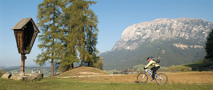
The tour to Aica di Fiè forms a figure eight around the Umser Feld and the Aichaberg, the junction to the Val di Tires and the Gruppo del Catinaccio/Rosengarten. The difference in altitude is split up over several small but never too steep climbs. This trip is not very demanding from the point of view of riding technique and can therefore be done by newcomers to mountain biking. Stunning views of the Sciliar/Schlern, Croda del Maglio/Hammerwand and Monte Cavone/Tschafon complete this ideal beginners’ tour.
The tour begins in a very relaxed fashion on the narrow road from Fiè to Umes, past strikingly beautiful old farmhouses, with the gigantic Croda del Maglio/Hammerwand and Monte Cavone/Tschafon firmly in view. After about two kilometres a gravel road climbs up in the direction of Moarmühle (mill). Above the Umser Feld you cruise along with stunning views over the valley to Umes.
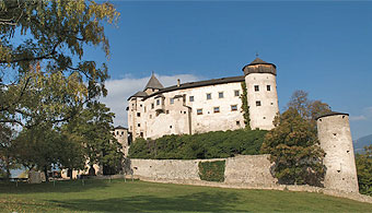
A short climb initially takes you in the direction of Monte Cavone/Tschafon. At the wooden bridge over the Schlernbach/Rio Sciliar a short descent begins past the sawmill at Umes in the direction of Presule. Climbing gently you reach this small village after a few kilometres where you can make a detour to the prominently located Schloss Prösels/Castel Presule. The Prösler Hof is the perfect refreshment stop at the approximate half-way point of this tour.
The route continues in the direction of Aica di Fiè, from where after a few metres you turn onto a hiking trail alongside woodland. Shortly before the intersection with the main road coming from the Valle Isarco you come across the tarmac road again. You follow it past Aica di Fiè as far as a tunnel.
Immediately behind the tunnel the route climbs left again slightly to the Schnaggenkreuz, a stunning vantage point with a view of the complete amphitheatre of mountains from the Sciliar to Monte Cavone. You travel through woodland to the sawmill at Umes climbing again briefly.
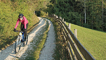
The old road from Umes to Fiè forms the crowning glory of this tour! This mostly gravelled idyllic section leads through cropped fields past old farmhouses to Fiè, in beautiful afternoon sunshine if the weather is fine.
|
| |
 |
| |
Variations
1. On the road to Umes: You can save yourself a few metres in altitude difference if you do not turn left at waymarker 3, but stay on the Umes road instead. At the bus stop at the beginning of the village of Umes go up left and at the next crossing left again. Follow this road uphill again. You join the tour described here again at waymarker 13 (at the water source).
2. Direct descent from the Schnaggenkreuz to Umes: Bear left on the gravel road to Umes at waymarker 33 immediately behind the Schnaggenkreuz. It joins the connecting road from Presule to Umes. Follow the road to the right downhill. You reach the tour described here again at waymarker 39. Turn sharp left and follow the road.
3. Omitting the trip around the Aichaberg: The tour is very short and easy if you leave out the trip round the Aichaberg! To this end do not go straight ahead at the wooden bridge at waymarker 21, but turn right on to the old Umes road (corresponds to waymarker 40) and continue the tour here. You save 9km in distance and 350m in altitude difference.
4. Extension via the protruding rock at Monte Cavone/Tschafon: Do not bear right downhill at the woodbridge over the Schlernbach/Rio Sciliar (waymarker 16), but bear left uphill in the direction of Monte Cavone/Tschafon. Turn right above the protruding rock at Monte Cavone in the direction of Schönblick. Continue via Tschötscher in the direction of the Schnaggenkreuz. Shortly before the Schnaggenkreuz you join the tour described here again at waymarker 31. This alternative is 8km in distance and 430m uphill in altitude difference. |
| |
|
| |
TOUR INFORMATION
Tour information |
|
% of distance |
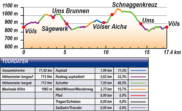
Total distance |
17,42 km |
100 % |
Height variation uphill |
713 Hm |
|
Height variation downhill |
713 Hm |
|
Maximum altitude |
1083 m |
|
Tarmac |
1,99 km |
| 11,5 % |
 |
|
Tarmac cycle path |
5,62 km |
32,3 %
|
 |
|
Gravel |
7,05 km |
| 40,5 % |
 |
|
Hiking trail |
2,73 km |
15,7 %
|
 |
|
Single track |
0,00 km |
0,0 %
|
 |
|
Carrying / pushing |
0,00 km |
0,0 %
|
 |
|
Cable car / transfer |
0,00 km |
0,0 %
|
 |
|
|
| |
|
|
Riding times |
Riding time without pauses |
Riding time at 10 km/h |
1 hr 45 min |
Riding time at 12 km/h |
1 hr 27 min |
Riding time at 14 km/h |
1 hr 15 min |
Riding time at 16 km/h |
1 hr 05 min |
Riding time at 18 km/h |
58 min |
Riding time at 20 km/h |
52 min |
| |
|
| |
|
| |
|
| |
|
| |
|
|
|
| |
|
Physical condition |
|
|
Overall condition |
2,5 |
|
Total height variation |
3,0 |
|
Total distance |
2,0 |
|
Maximum altitude |
2,0 |
|
|
|
Riding technique |
|
|
Overall riding technique |
2,9 |
|
Surface |
2,7 |
|
Average climb gradient Ø |
3,0 |
|
Average descent gradient Ø |
3,0 |
|
|
|
| |
|
Tour evaluation |
|
|
Overall difficulty |
2,7 |
|
Climb difficulty |
2,6 |
|
Descent difficulty |
2,7 |
|
|
|
Emotional experience |
|
|
Panorama |
4,0 |
|
Riding fun |
3,0 |
|
| |
|
|
|
|
| |
|
GETTING THERE AND STARTING POINT
Getting there
Coming from the north take the motorway (A22) exit for Chiusa – Alpe di Siusi/Sciliar, SS12 as far as Ponte Gardena, then in the direction of Alpe di Siusi.
Coming from the south take motorway (A22) exit for Bolzano Nord – Alpe di Siusi/Sciliar, SS12 as far as Prato all'Isarco, then in the direction of Alpe di Siusi.
Starting point
There are several car parks and underground parking facilities in all villages. Parking spaces marked in blue are subject to charges. Tickets are available from the appropriate automatic machines. All other parking spaces are free of charge.
The tour begins at the tourism association Fiè. |
| |
ROADBOOK
No |
km |
Next |
Hm |
Sym |
Location |
Direction |
Route |
Time 22 km/h |
Time 10 km/h |
1 |
0,00 |
0,04 |
859 |
|
Tourism association in Fiè |
Straight ahead direction roundabout |
|
00:00 |
00:00 |
2 |
0,04 |
1,73 |
859 |
|
Roundabout Fiè |
Left Umes |
|
00:00 |
00:00 |
3 |
1,77 |
0,12 |
907 |
|
Junction after bridge |
Left Sciliar/Schlern, loop road Umes, Hofer Alpl |
|
00:04 |
00:10 |
4 |
1,89 |
0,08 |
927 |
|
End of tarmac road |
Straight ahead |
|
00:05 |
00:11 |
5 |
1,97 |
0,15 |
938 |
|
Access road to farm (direction Lake - Laghetto di Fiè) |
Sharp right follow main trail |
|
00:05 |
00:11 |
6 |
2,12 |
0,08 |
958 |
|
Junction to Umes |
Straight ahead Lake- Laghetto di Fiè |
|
00:05 |
00:12 |
7 |
2,20 |
0,05 |
965 |
|
Junction to Tuff mountain pasture |
Straight ahead |
|
00:06 |
00:13 |
8 |
2,25 |
0,39 |
973 |
|
Junction to Sciliar/Schlern in bend |
Right follow main trail |
|
00:06 |
00:13 |
9 |
2,64 |
0,27 |
1013 |
|
Junction after left-hand bend |
Bear right loop road Umes |
|
00:07 |
00:15 |
10 |
2,91 |
0,36 |
1010 |
|
Junction |
Bear right downhill |
|
00:07 |
00:17 |
11 |
3,27 |
0,03 |
1003 |
|
Fork |
Bear left |
|
00:08 |
00:19 |
12 |
3,30 |
0,31 |
1004 |
|
Intersection in bend |
Bear right downhill |
|
00:09 |
00:19 |
13 |
3,61 |
0,30 |
976 |
|
Junction Umes (water source) |
Bear left Tschafon (Monte Cavone) 4 |
|
00:09 |
00:21 |
14 |
3,91 |
0,45 |
1014 |
|
Maso Platzlunger Hof |
Bear right Tschafon (Monte Cavone) 4 |
|
00:10 |
00:23 |
15 |
4,36 |
0,03 |
1019 |
|
Wayside cross |
Right across wooden bridge |
|
00:11 |
00:26 |
16 |
4,39 |
0,55 |
1018 |
|
Intersection in bend |
Bear right downhill |
|
00:11 |
00:26 |
17 |
4,94 |
0,13 |
938 |
|
Beginning of tarmac road |
Straight ahead |
|
00:13 |
00:29 |
18 |
5,07 |
0,18 |
921 |
|
Junction |
Straight ahead downhill |
|
00:13 |
00:30 |
19 |
5,25 |
0,54 |
900 |
|
Sawmill |
Left Presule |
|
00:14 |
00:31 |
20 |
5,79 |
0,04 |
834 |
|
Junction to Presule |
Bear right downhill Prösels (Presule) 6 |
|
00:15 |
00:34 |
21 |
5,83 |
1,05 |
829 |
|
Wooden bridge |
Straight ahead Prösels (Presule) 6 |
|
00:15 |
00:34 |
22 |
6,88 |
0,48 |
861 |
|
Intersection tarmac road |
Bear right Prösels (Presule) 6 |
|
00:18 |
00:41 |
23 |
7,36 |
0,27 |
853 |
|
Prösler Hof |
Bear left Aica di Fiè |
|
00:20 |
00:44 |
24 |
7,63 |
0,93 |
863 |
|
Junction |
Bear left Aica di Fiè 6 |
|
00:20 |
00:45 |
25 |
8,56 |
0,06 |
928 |
|
Intersection |
Bear right downhill |
|
00:23 |
00:51 |
26 |
8,62 |
0,39 |
925 |
|
Intersection bus stop |
Bear left uphill |
|
00:23 |
00:51 |
27 |
9,00 |
0,76 |
939 |
|
Crossroad |
Straight ahead |
|
00:25 |
00:54 |
28 |
9,76 |
0,38 |
914 |
|
Junction |
Straight ahead |
|
00:26 |
00:58 |
29 |
10,15 |
0,03 |
914 |
|
Junction after short tunnel |
Left Bar Wagner |
|
00:27 |
01:00 |
30 |
10,18 |
0,46 |
914 |
|
Junction before underpass |
Right uphill |
|
00:27 |
01:01 |
31 |
10,64 |
0,13 |
1003 |
|
Intersection |
Straight ahead Presule |
|
00:29 |
01:03 |
32 |
10,77 |
0,06 |
1011 |
|
Schnaggenkreuz |
Right |
|
00:29 |
01:04 |
33 |
10,83 |
0,18 |
1010 |
|
Junction to Umes |
Straight ahead |
|
00:29 |
01:04 |
34 |
11,00 |
0,43 |
1017 |
|
Junction |
Bear right uphill |
|
00:30 |
01:6 |
35 |
11,43 |
0,54 |
1082 |
|
Junction (to Schönblick) |
Bear left Umes |
|
00:31 |
01:08 |
36 |
11,97 |
2,12 |
1049 |
|
Beginning of gravel road |
Straight ahead |
|
00:32 |
01:11 |
37 |
14,09 |
0,18 |
921 |
|
Intersection tarmac road |
Sharp left downhill |
|
00:38 |
01:24 |
38 |
14,27 |
0,54 |
900 |
|
Sawmill Umes |
Left Presule |
|
00:38 |
02:25 |
39 |
14,81 |
0,04 |
834 |
|
Junction to Presule |
Bear right downhill Prösels (Presule) 6 |
|
00:40 |
02:28 |
40 |
14,85 |
0,25 |
829 |
|
Wooden bridge |
Right Völs (Fiè) |
|
00:40 |
01:29 |
41 |
15,10 |
0,60 |
831 |
|
Trafisöhr Hof |
Bear left downhill Völs (Fiè) |
|
00:41 |
01:30 |
42 |
15,70 |
0,12 |
842 |
|
Junction |
Bear right |
|
00:42 |
01:34 |
43 |
15,82 |
0,10 |
838 |
|
Wooden bridge |
Left Völs (Fiè) 6 |
|
00:43 |
01:34 |
44 |
15,92 |
0,55 |
849 |
|
End of tarmac road |
Straight ahead |
|
00:43 |
01:35 |
45 |
16,47 |
0,14 |
853 |
|
Crossroad |
Straight ahead Fiè (Fiè) 6 |
|
00:44 |
01:38 |
46 |
16,61 |
0,39 |
866 |
|
Intersection tarmac road |
Bear left downhill Völs (Fiè) 6 |
|
00:45 |
01:39 |
47 |
17,00 |
0,38 |
841 |
|
Intersection main road |
Bear right uphill |
|
00:46 |
01:41 |
48 |
17,38 |
0,04 |
859 |
|
Roundabout Fiè |
Bear right Castelrotto (2nd exit) |
|
00:47 |
01:44 |
49 |
17,42 |
0,00 |
859 |
|
Tourism association Fiè |
End of tour |
|
00:47 |
01:44 |
EXPLANATION OF EVALUATION FACTORS, SURFACE AND SLOPE
Explanation of evaluation factors
• Overall difficulty based on climb difficulty (60%) and descent difficulty (40%)
• Climb difficulty based on total distance uphill (30%), overall height variation uphill (30%), surface uphill (10%), average slope uphill (25%), highest altitude reached (5%).
• Descent difficulty consists of total distance downhill (10%), overall height variation downhill (10%), surface downhill (50%), average slope downhill (30%).
• Physical condition based on total distance (40%), with overall height variation (50%) and highest altitude reached (10%).
• Riding technique based on surface (50%), with average slope uphill (30%) and average slope downhill (20%).
• Writer’s subjective evaluation of panorama and riding fun.
Explanation of surface and slope |
|
|
|
A = Tarmac road |
|
steep uphill |
from + 15% |
R = Tarmac cycle path |
|
uphill |
up to + 14% |
S = Gravel |
|
level |
ca. +/- 4% |
W = Hiking trail |
|
downhill |
up to - 19% |
P = Path, Single Trail |
|
steep downhill |
from - 20% |
T = Carrying / pushing |
|
|
|
X = Cable car / transfer |
|
|
|
Route: the percentages indicate the average climb (+) or the average descent (-) to the next waymarker. |
DOWNLOADS
| |
 |
 |
 |
 |
CHARACTERISTICS |
ALTITUDE PROFILE |
ROADBOOK |
MAP |
|
| |
|

