|
CHARACTERISTICS AND VARIATIONS
Characteristics
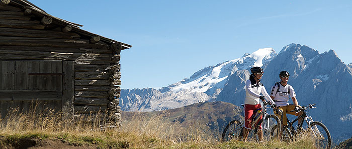
This wonderful route could equally well be called the “Val Duron for connoisseurs”. In contrast to the “Val Duron” tour, however, bikers can appreciate the landscape on a wonderful descent through this largely unspoilt valley that forms the border with the Rosengarten/Catinaccio Group. Moreover, thanks to the 1,000m ascent by cable car, the return journey from the Fassa Valley to the Col Rodella is also a pleasant experience. Add to this the spectacular panoramic trail up to the Dialer Church and the marvellous descent under the “City of Stone” and this tour can well be described as one of the finest in the region, its 1,000m of ascent presenting no difficulties for fit bikers.
The first few kilometres towards Ciaslat are an ideal warm-up, with the short but pleasant trail towards Monte Pana offering an idea of what the tour has in store for you: after a quick climb on tarmac, the long climb begins on a gravel road to the Zallinger Hut, your gaze fixed on the Plattkofel/Sassopiatto.
After a climb of 600m you reach the Zallinger Hut, the first opportunity for refreshments: relax on its terrace and enjoy the view from its terrace to the south-east over the “flat” face of the Plattkofel/Sassopiatto, while to the south-west is the panorama in the direction of the Plattkofel/Sassopiatto Hut, Palatsch/Palacia, the Mahlknecht Hut and the Rosszähne/Denti di Terra Rossa. Suitably fortified, you can now face the remaining 400m or so of the climb up to the pass of the Mahlknechtjoch/Passo Duron, followed by a short descent on the road towards Tirler and Saltria. Here a gravel road begins that after 1.4 km takes you up to the high-level route between the Zallinger Hut and the Dialer Church, a beautiful trail that continues slightly uphill to the former Dialer Hut.
After a short stretch up to the Tierser Alpl Hut, an exceptional trail to the Mahlknechtjoch/Passo Duron marks the beginning of the wonderful 10-km descent through the Duron Valley. Bounded by the Rosengartengruppe/Catinaccio Group to the south and the Plattkofel/Sassopiatto to the north, the valley runs eastwards to Campitello in the Fassa Valley. On clear days stop during the upper stages and look to the east, where you can even see the icy summit of the Marmolada!
Exactly halfway down the valley you reach the very traditional Lino Brach Hut at the side of the path, where you can stop to regain your strength and enjoy the peace and tranquillity; among the gastronomic treats on offer we recommend the polenta with sausage and gorgonzola. Shortly after comes the Duron Hut, then a descent through the forest, in parts very steep. Arriving in Campitello, you take the giant cable car up to Col Rodella, which is big enough to accommodate even hang-gliders. A few minutes later and 1,000m higher, you are at the top, asking yourself why can’t every climb on a mountain bike be this easy.
Admiring the panorama of the Langkofel/Sassolungo, you pass the Salei Hut in the direction of the City of Stone, beginning the idyllic conclusion to this unforgettable tour: a narrow trail, characterised by some hairpin bends, leads down below the City of Stone to Plan de Gralba, then becoming a wide gravel path. From here, the trail is on the ski piste down to the Grödner Tal/Val Gardena, with the last section following the old railway line back to Wolkenstein/Selva. Here you can look back in happy amazement at the infinity of mountain bike adventures offered by an ascent of just 1,000m!
|
 |
Variations
1. Pain and pleasure: extension to the Tierser Alpl Hut. If, having reached the top of the Val Duron, you still have the appetite for new adventures, you can take the very steep section up towards the Tierser Alpl Hut. At waymarker 35, rather than left, go straight on to the trail, which later becomes a cart track up to the hut. A climb of 220m brings you to an oasis of tranquillity under the Rosszähne/Denti di Terra Rossa. Why not spend the night at the hut? Enjoy the warm welcome amid the splendid surroundings, then return the following day down to waymarker 35 and bear right down into the Val Duron.
|
|
| |
TOUR INFORMATION
Tour information |
|
% of distance |
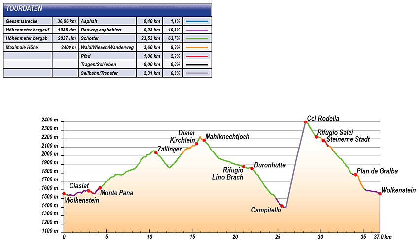
Total distance |
36,96 km |
100 % |
Height variation uphill |
1038 Hm |
|
Height variation downhill |
2037 Hm |
|
Maximum altitude |
2400 m |
|
Tarmac |
0,40 km |
| 1,1 % |
 |
|
Tarmac cycle path |
6,03 km |
16,3 %
|
 |
|
Gravel |
23,53 km |
| 63,7 % |
 |
|
Hiking trail |
1,60 km |
9,8 %
|
 |
|
Single track |
1,06 km |
2,9 %
|
 |
|
Carrying / pushing |
0,00 km |
0,0 %
|
 |
|
Cable car / transfer |
2,31 km |
6,3 %
|
 |
|
|
| |
|
|
Riding times |
Riding time without pauses |
Riding time at 10 km/h |
3 hrs 42 min |
Riding time at 12 km/h |
3 hrs 05 min |
Riding time at 14 km/h |
2 hrs 38 min |
Riding time at 16 km/h |
2 hrs 19 min |
Riding time at 18 km/h |
2 hrs 03 min |
Riding time at 20 km/h |
1 hr 51 min |
| |
|
| |
|
| |
|
| |
|
| |
|
|
|
| |
|
Physical condition |
|
|
Overall condition |
3,1 |
|
Total height variation |
3,0 |
|
Total distance |
3,0 |
|
Maximum altitude |
4,0 |
|
|
|
Riding technique |
|
|
Overall riding technique |
3,5 |
|
Surface |
2,9 |
|
Average climb gradient Ø |
4,0 |
|
Average descent gradient Ø |
4,0 |
|
|
|
| |
|
Tour evaluation |
|
|
Overall difficulty |
3,5 |
|
Climb difficulty |
3,3 |
|
Descent difficulty |
3,7 |
|
|
|
Emotional experience |
|
|
Panorama |
5,0 |
|
Riding fun |
4,0 |
|
| |
|
|
|
|
| |
|
GETTING THERE AND STARTING POINT
Getting there
A22 motorway: coming from the north, take exit Innsbruck-Brennero; coming from the south, take exit Verona-Bolzano.
We recommend you exit the A22 at Klausen/Chiusa – Grödner Tal/Val Gardena: after 20 minutes on a well-signposted Alpine road you reach St. Ulrich/Ortisei then, after a few km, St. Christina/Santa Cristina and Wolkenstein/Selva.
Starting point
The tourist information office in Wolkenstein/Selva is located some 500 m after the entrance to the locality on the left.
Parking facilities: at the start of the centre of Wolkenstein/Selva, before the Piazza Nives, take two consecutive left turns to reach the car park of the same name.
The tour begins at the tourist information office in Wolkenstein/Selva. |
| |
ROADBOOK
No |
km |
Next |
Hm |
Sym |
Location |
Direction |
Route |
Time 22 km/h |
Time 10 km/h |
1 |
0,00 |
0,05 |
1557 |
|
Tourist information office in Wolkenstein/Selva |
Straight on downhill |
|
00:00 |
00:00 |
2 |
0,05 |
0,05 |
1554 |
|
Café Mozart |
Sharp left onto permanent hiking trail |
|
00:00 |
00:00 |
3 |
0,10 |
0,06 |
1550 |
|
Casa Elisabetha |
Sharp right downhill |
|
00:00 |
00:00 |
4 |
0,17 |
0,20 |
1548 |
|
End of tarmac |
Straight on |
|
00:00 |
00:00 |
5 |
0,37 |
0,08 |
1543 |
|
Fire station |
Straight on |
|
00:01 |
00:02 |
6 |
0,45 |
0,43 |
1540 |
|
House of Culture |
Bear left |
|
00:01 |
00:02 |
7 |
0,88 |
0,18 |
1541 |
|
Junction at signpost 30 |
Straight on |
|
00:02 |
00:05 |
8 |
1,06 |
0,51 |
1535 |
|
Junction with hiking trail 22A |
Straight on following road |
|
00:02 |
00:06 |
9 |
1,57 |
0,25 |
1567 |
|
Transformer, bus stop La Selva |
Bear right to Monte Pana |
|
00:04 |
00:09 |
10 |
1,81 |
0,89 |
1572 |
|
Junction to Fischburg/Castel Gardena |
Straight on to Monte Pana |
|
00:04 |
00:10 |
11 |
2,71 |
0,04 |
1592 |
|
End of tarmac |
Straight on |
|
00:07 |
00:16 |
12 |
2,75 |
0,12 |
1587 |
|
Junction |
Straight on |
|
00:07 |
00:16 |
13 |
2,87 |
0,09 |
1590 |
|
Ciaslat (towards Sellajoch/Passo Sella) |
Straight on |
|
00:07 |
00:17 |
14 |
2,96 |
0,50 |
1581 |
|
End of gravel path |
Straight on |
|
00:08 |
00:17 |
15 |
3,46 |
0,08 |
1562 |
|
Beginning of tarmac |
Straight on |
|
00:09 |
00:20 |
16 |
3,54 |
0,58 |
1555 |
|
Prensanueva apartments |
Bear left to Monte Pana |
|
00:09 |
00:21 |
17 |
4,12 |
0,09 |
1625 |
|
Junction to S. Cristina, Selva/Wolkenstein |
Bear left following road |
|
00:11 |
00:24 |
18 |
4,21 |
0,39 |
1624 |
|
Crossing with bottom of Monte Pana lift |
Straight on Saltria 30 |
|
00:11 |
00:25 |
19 |
4,61 |
0,40 |
1662 |
|
Junction to ski jump |
Straight on uphill |
|
00:12 |
00:27 |
20 |
5,01 |
0,83 |
1702 |
|
Junction (towards Strena) |
Straight on uphill |
|
00:13 |
00:30 |
21 |
5,83 |
0,69 |
1760 |
|
Junction to Jender Valley |
Bear left to Saltria |
|
00:15 |
00:34 |
22 |
6,52 |
0,46 |
1782 |
|
Junction to Langkofelscharte gorge |
Straight on to Saltria |
|
00:17 |
00:39 |
23 |
6,98 |
0,35 |
1788 |
|
Junction to Langkofelscharte gorge |
Straight on uphill |
|
00:19 |
00:41 |
24 |
7,33 |
3,11 |
1815 |
|
Junction |
Bear left to Zallinger |
|
00:19 |
00:43 |
25 |
10,44 |
0,14 |
2060 |
|
Junction to Plattkofel Hut |
Bear right to Zallinger 9 |
|
00:28 |
01:02 |
26 |
10,58 |
0,18 |
2053 |
|
Junction towards Florian chairlift |
Bear left to Zallinger, Saltria 9 |
|
00:28 |
01:03 |
27 |
10,76 |
0,47 |
2037 |
|
Zallinger Hut, chapel, water source |
Bear right downhill |
|
00:29 |
01:04 |
28 |
11,23 |
1,14 |
1996 |
|
Bridge over stream Junction to Dialer church 7 |
Straight on to Saltria 8 |
|
00:30 |
01:07 |
29 |
12,37 |
0,30 |
1859 |
|
Junction to bend |
Bear left uphill |
|
00:33 |
01:14 |
30 |
12,67 |
1,12 |
1891 |
|
Junction to bend |
Bear right uphill |
|
00:34 |
01:16 |
31 |
13,79 |
1,33 |
2021 |
|
Junction |
Sharp right to Molignon Hut |
|
00:37 |
01:22 |
32 |
15,12 |
0,25 |
2119 |
|
Junction to Plattkofel Hut |
Straight on |
|
00:41 |
01:30 |
33 |
15,37 |
0,12 |
2130 |
|
Below Dialer Church/Chapel of St. Anthony |
Sharp left to Tierser Alpl |
|
00:41 |
01:32 |
34 |
15,49 |
0,42 |
2143 |
|
Dialer Church/Chapel of St. Anthony |
Bear right to Tierser Alpl |
|
00:42 |
01:32 |
35 |
15,91 |
0,38 |
2226 |
|
Electric fence |
Bear right to Plattkofel Hut |
|
00:43 |
01:35 |
36 |
16,29 |
0,08 |
2186 |
|
Junction |
Bear left on flat |
|
00:44 |
01:37 |
37 |
16,37 |
1,16 |
2185 |
|
Mahlknechtjoch/Passo Duron |
Right to Val Duron |
|
00:44 |
01:38 |
38 |
17,54 |
0,72 |
2047 |
|
Hut |
Straight on downhill |
|
00:47 |
01:45 |
39 |
18,25 |
1,91 |
1967 |
|
Junction to Antermoia Hut |
Straight on Campitello |
|
00:49 |
01:49 |
40 |
20,16 |
0,86 |
1897 |
|
Junction to Antermoia Hut |
Straight on Campitello |
|
00:54 |
02:00 |
41 |
21,02 |
0,90 |
1875 |
|
Lino Brach Hut |
Straight on |
|
00:57 |
02:06 |
42 |
21,92 |
0,03 |
1865 |
|
Junction above Duron Hut |
Right following main hiking trail |
|
00:59 |
02:11 |
43 |
21,95 |
0,06 |
1861 |
|
Junction to Plattkofel Hut |
Bear right downhill to Campitello |
|
00:59 |
02:11 |
44 |
22,01 |
0,18 |
1852 |
|
Duron Hut |
Straight on |
|
01:00 |
02:12 |
45 |
22,19 |
0,03 |
1828 |
|
Junction to Antermoia Hut |
Straight on Campitello |
|
01:00 |
02:13 |
46 |
22,22 |
1,05 |
1827 |
|
Junction to Sentiero per Campitello |
Straight on |
|
01:00 |
02:13 |
47 |
23,27 |
0,83 |
1679 |
|
Junction towards Sandro Pertini Hut |
Straight on |
|
01:03 |
02:19 |
48 |
24,10 |
0,08 |
1568 |
|
Bridge over stream |
Straight on |
|
01:05 |
02:24 |
49 |
24,18 |
0,61 |
1557 |
|
Junction |
Straight on |
|
01:05 |
02:25 |
50 |
24,79 |
0,53 |
1500 |
|
Bridge over stream, car park |
Straight on |
|
01:07 |
02:28 |
51 |
25,32 |
0,19 |
1430 |
|
Junction after first houses |
Straight on along stream |
|
01:09 |
02:31 |
52 |
25,51 |
0,34 |
1414 |
|
Albergo Ladino in Campitello |
Left/right via Pent de Sèra |
|
01:09 |
02:33 |
53 |
25,84 |
0,10 |
1400 |
|
Car park at bottom of Col Rodella lift |
Left towards cable car |
|
01:10 |
02:35 |
54 |
25,94 |
2,31 |
1400 |
|
Bottom of Col Rodella lift in Campitello |
Take cable car |
|
01:10 |
02:35 |
55 |
28,25 |
0,14 |
2399 |
|
Top of Col Rodella lift |
Straight on |
|
01:17 |
02:49 |
56 |
28,39 |
0,51 |
2400 |
|
Rifugio des Alpes hut |
Straight on Passo Sella |
|
01:17 |
02:50 |
57 |
28,91 |
0,47 |
2313 |
|
Crossroads |
Right Passo Sella |
|
01:18 |
02:53 |
58 |
29,37 |
0,19 |
2243 |
|
Junction to Rodella Hut |
Straight on Passo Sella |
|
01:20 |
02:56 |
59 |
29,56 |
0,51 |
2224 |
|
Salei Hut |
Straight on |
|
01:20 |
02:57 |
60 |
30,07 |
0,16 |
2212 |
|
Crossroads (to Salei Hut) |
Bear left at meadow |
|
01:22 |
03:00 |
61 |
30,23 |
0,11 |
2190 |
|
Junction near chapel |
Straight on |
|
01:22 |
03:01 |
62 |
30,34 |
0,06 |
2181 |
|
Car park at bottom of Langkofelscharte gorge lift |
Straight on |
|
01:22 |
03:02 |
63 |
30,40 |
0,10 |
2180 |
|
Intersection with gravel road |
Right downhill |
|
01:22 |
03:02 |
64 |
30,51 |
0,49 |
2171 |
|
Crossroads by hut |
Straight on Plan de Gralba |
|
01:23 |
03:03 |
65 |
30,99 |
0,03 |
2113 |
|
Hut (fence) |
Straight on between hut and barn |
|
01:24 |
03:05 |
66 |
31,02 |
0,05 |
2111 |
|
Path junction |
Straight on over meadow |
|
01:24 |
03:06 |
67 |
31,08 |
0,53 |
2108 |
|
Crossroads |
Straight on |
|
01:24 |
03:06 |
68 |
31,61 |
0,63 |
2047 |
|
Crossroads |
Straight on |
|
01:26 |
03:09 |
69 |
32,24 |
0,60 |
1975 |
|
Intersection |
Bear right to Plan de Gralba, Selva |
|
01:27 |
03:13 |
70 |
32,84 |
0,69 |
1910 |
|
Wayside cross |
Follow main path |
|
01:29 |
03:17 |
71 |
33,54 |
0,27 |
1805 |
|
Junction to Jeuf de Frea (near bottom of drag lift) |
Straight on |
|
01:31 |
03:21 |
72 |
33,80 |
0,14 |
1787 |
|
Bridge over Rio Gardena stream |
Bear right over bridge |
|
01:32 |
03:22 |
73 |
33,94 |
0,15 |
1783 |
|
Bottom of the Piz Sella lift |
Left |
|
01:32 |
03:23 |
74 |
34,09 |
0,10 |
1781 |
|
Bridge over Plan de Gralba stream |
Left to Plan Selva (over bridge) |
|
01:32 |
03:24 |
75 |
34,19 |
0,06 |
1785 |
|
Covered snowgun |
Bear right to Wolkenstein/Selva |
|
01:33 |
03:25 |
76 |
34,25 |
0,79 |
1782 |
|
Junction at edge of forest |
Bear right downhill to Wolkenstein/Selva |
|
01:33 |
03:25 |
77 |
35,04 |
0,19 |
1621 |
|
Bridge over stream |
Bear right over bridge then along stream |
|
01:35 |
03:30 |
78 |
35,23 |
0,25 |
1604 |
|
Carpentry shop |
Straight on to Wolkenstein/Selva |
|
01:36 |
03:31 |
79 |
35,48 |
0,06 |
1589 |
|
Intersection with main road |
Sharp right to Plan de Gralba |
|
01:36 |
03:32 |
80 |
35,53 |
0,77 |
1593 |
|
Casa Alpina |
Bear right (left along sports ground) |
|
01:36 |
03:33 |
81 |
36,31 |
0,28 |
1581 |
|
Hotel La Tambra |
Bear left onto course of old railway |
|
01:39 |
03:37 |
82 |
36,58 |
0,09 |
1577 |
|
Hotel Sun Valley |
Sharp left downhill |
|
01:39 |
03:39 |
83 |
36,67 |
0,04 |
1567 |
|
Intersection with main road |
Sharp right |
|
01:40 |
03:40 |
84 |
36,71 |
0,09 |
1566 |
|
Hotel Krone |
Bear left following main road |
|
01:40 |
03:40 |
85 |
36,79 |
0,17 |
1566 |
|
Bottom of Ciampinoi lift |
Straight on |
|
01:40 |
03:40 |
86 |
36,96 |
0,00 |
1557 |
|
Tourist information office in Wolkenstein/Selva |
End of tour |
|
01:40 |
03:41 |
EXPLANATION OF EVALUATION FACTORS, SURFACE AND SLOPE
Explanation of evaluation factors
• Overall difficulty based on climb difficulty (60%) and descent difficulty (40%)
• Climb difficulty based on total distance uphill (30%), overall height variation uphill (30%), surface uphill (10%), average slope uphill (25%), highest altitude reached (5%).
• Descent difficulty consists of total distance downhill (10%), overall height variation downhill (10%), surface downhill (50%), average slope downhill (30%).
• Physical condition based on total distance (40%), with overall height variation (50%) and highest altitude reached (10%).
• Riding technique based on surface (50%), with average slope uphill (30%) and average slope downhill (20%).
• Writer’s subjective evaluation of panorama and riding fun.
Explanation of surface and slope |
|
|
|
A = Tarmac road |
|
steep uphil |
from + 15% |
R = Tarmac cycle path |
|
uphill |
up to + 14% |
S = Gravel |
|
level |
ca. +/- 4% |
W = Hiking trail |
|
downhill |
up to - 19% |
P = Path, Single Trail |
|
steep downhill |
from - 20% |
T = Carrying / pushing |
|
|
|
X = Cable car / transfer |
|
|
|
Route: the percentages indicate the average climb (+) or the average descent (-) to the next waymarker. |
DOWNLOADS
| |
 |
 |
 |
 |
CHARACTERISTICS |
ALTITUDE PROFILE |
ROADBOOK |
MAP |
|
| |
|