|
CHARACTERISTICS AND VARIATIONS
Characteristics
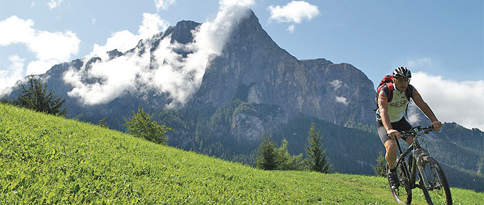
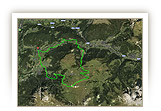
Fantastic panorama, a treat for riding technique fans, more than 1,000m in altitude difference, varied descent and really good stops for refreshment and all that with hardly having to climb a metre in altitude!
The Alpe di Siusi aerial cableway makes this possible. It takes over the bulk of the altitude difference for this tour. This makes the tour via the Marinzen hut perfectly suitable for less physically fit bikers or for a quick half-day excursion.
At the valley station of the Alpe di Siusi cable car you can push your bike easily into the spacious cabins of the aerial cableway that came into service in 2005. A short time later you get out at Compaccio, the highest point of the tour. Now it is almost only downhill! A short distance below Compaccio you turn onto a hiking trail at Gasthaus Zorzi in the direction of the car park at Spitzbühl. After Jaggl Hut this hiking trail becomes a fun trail that disgorges the now wide-awake biker onto the car park of the chair lift at Spitzbühel.
Now you follow the Alpe di Siusi road downhill for a few metres before the route runs into the gravel road that runs parallel on the right in the direction of Gstatsch. At waymarker 13 you have to decide. The following section of trail is a pleasure for riding technique fans. Bikers who are not so strong on riding technique should take the Alpe di Siusi road and roll down the three hairpin bends as far as Gstatsch.
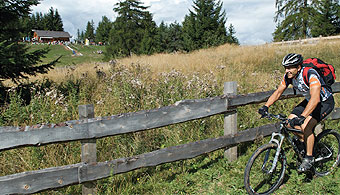
At the Gasthaus Gstatsch the varied mountain trail to the Marinzen hut begins. After a short section of woodland you come to a mountain pasture. You should definitely stop here and look around. The view of the Sciliar/Schlern with its characteristic Santner Peak is impressive.
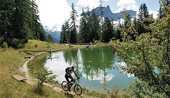
After a lot of uphill and downhill you will reach the stunningly located Marinzen hut . It is unlikely that you will be on your own very often here. An old chair lift brings day-trippers up from Castelrotto. The beautiful mountain pastures with horses, goats and an idyllic small lake is a popular destination for excursions. You can have a fantastic rest on the sun terrace with its view of the Sciliar/Schlern.
Alternatively a kilometre further on you can stop for a bite in the much quieter Schafstall, a mountain hut in a remote location in rather shady woodland. From there a steep gravel road leads downhill Wasserebene. Finally, with a stunning view of Castelrotto you cruise along on a small tarmac road to the control point at San Valentino and back to Siusi to the valley station of the Alpe di Siusi aerial cableway.
|
| |
 |
| |
Variations
1. Climb by bike: Whoever wants to do the 1,070m of difference in altitude by bike can do this easiest by taking the Alpe di Siusi road to Compaccio. The road is closed to normal traffic from 9am. Only buses and residents can use it then. A short distance before the Gasthaus Zorzi you join the tour described here at waymarker 4.
2. Extended tour via Alpe di Siusi: If you use the Alpe di Siusi aerial cableway for the ascent, you can use the energy saved for the beautiful alternative via the Alpenhotel Panorama, Laurin Hut and Spitzbühel. To this end, do not turn right at waymarker 3, but left in the direction of Saltria. After a kilometre bear right for Hotel Steger Dellai and follow the signs for Sciliar. Go downhill from the Spitzbühel to the car park at the valley station of the chair lift of the same name. At waymarker 10 join the tour described here again.
3. Alternative way back: At waymarker 29 do not go straight ahead, but right steeply downhill.
Then via Wasserebene, Tiosels and the hiking trail 7 to San Costantino and Siusi. |
| |
|
| |
TOUR INFORMATION
Tour information |
|
% of distance |
Total distance |
18,98 km |
100 % |
Height variation uphill |
227 Hm |
|
Height variation downhill |
1070 Hm |
|
Maximum altitude |
1855 m |
|
Tarmac |
0,00 km |
| 0,0 % |
 |
|
Tarmac cycle path |
6,37 km |
33,6 %
|
 |
|
Gravel |
5,67 km |
| 29,9 % |
 |
|
Hiking trail |
1,66 km |
8,8 %
|
 |
|
Single track |
1,16 km |
6,2 %
|
 |
|
Carrying / pushing |
0,00 km |
0,0 %
|
 |
|
Cable car / transfer |
4,11 km |
21,7 %
|
 |
|
|
| |
|
|
Riding times |
Riding time without pauses |
Riding time at 10 km/h |
1 hr 54 min |
Riding time at 12 km/h |
1 hr 35 min |
Riding time at 14 km/h |
1 hr 21 min |
Riding time at 16 km/h |
1 hr 11 min |
Riding time at 18 km/h |
1 hr 03 min |
Riding time at 20 km/h |
57 min |
| |
|
| |
|
| |
|
| |
|
| |
|
|
|
| |
|
Physical condition |
|
|
Overall condition |
2,6 |
|
Total height variation |
3,0 |
|
Total distance |
2,0 |
|
Maximum altitude |
3,0 |
|
|
|
Riding technique |
|
|
Overall riding technique |
3,6 |
|
Surface |
2,5 |
|
Average climb gradient Ø |
5,0 |
|
Average descent gradient Ø |
4,0 |
|
|
|
| |
|
Tour evaluation |
|
|
Overall difficulty |
3,2 |
|
Climb difficulty |
3,0 |
|
Descent difficulty |
3,5 |
|
|
|
Emotional experience |
|
|
Panorama |
5,0 |
|
Riding fun |
4,0 |
|
| |
|
|
|
|
| |
|
GETTING THERE AND STARTING POINT
Getting there
Coming from the north take the motorway (A22) exit for Chiusa – Alpe di Siusi/Sciliar, SS12 as far as Ponte Gardena, then in the direction of Alpe di Siusi.
Coming from the south take motorway (A22) exit for Bolzano Nord – Alpe di Siusi/Sciliar, SS12 as far as Prato all'Isarco, then in the direction of Alpe di Siusi.
Starting point
There is a large bus and car park free of charge at the valley station of the Alpe di Siusi cable car station in Siusi.
The tour begins at the valley station of the Alpe di Siusi aerial cableway in Siusi.
|
| |
ROADBOOK
No |
km |
Next |
Hm |
Sym |
Location |
Direction |
Route |
Time 22 km/h |
Time 10 km/h |
1 |
0,00 |
4,11 |
1012 |
|
Valley station Alpe di Siusi aerial cableway |
Take gondola lift |
|
00:00 |
00:00 |
2 |
4,11 |
0,25 |
1855 |
|
Mountain station Alpe di Siusi aerial cableway |
Right take steps |
|
00:11 |
00:24 |
3 |
4,37 |
0,24 |
1841 |
|
Compaccio |
Right downhill |
|
00:11 |
00:26 |
4 |
4,60 |
0,03 |
1827 |
|
Junction |
Left Gasthof Zorzi |
|
00:12 |
00:27 |
5 |
4,63 |
0,12 |
1826 |
|
Gasthaus Zorzi |
Right car park Spitzbühel |
|
00:12 |
00:27 |
6 |
4,76 |
0,13 |
1802 |
|
Start of tarmac road |
Straight ahead |
|
00:12 |
00:28 |
7 |
4,89 |
0,22 |
1787 |
|
Jaggl Schwaige |
Straight ahead downhill |
|
00:13 |
00:29 |
8 |
5,11 |
0,31 |
1761 |
|
Hotel Seelaus |
Straight ahead car park Spitzbühel , Kastelruth 4 |
|
00:13 |
00:30 |
9 |
5,42 |
0,11 |
1723 |
|
Above car park Spitzbühel |
Straight ahead along fence |
|
00:14 |
00:32 |
10 |
5,53 |
0,20 |
1710 |
|
Hairpin bend car park Spitzbühel, bus stop |
Straight ahead downhill Alpe di Siusi road |
|
00:15 |
00:33 |
11 |
5,72 |
0,46 |
1696 |
|
Junction at small car park |
Bear right 12a Gstatsch, Marinzen refuge |
|
00:15 |
00:34 |
12 |
6,19 |
0,55 |
1675 |
|
Crossroads gravel road |
Straight ahead 12a Gstatsch, Marinzen refuge |
|
00:16 |
00:37 |
13 |
6,74 |
0,53 |
1618 |
|
Junction at hairpin bend |
Right 12a Gstatsch, Marinzen refuge |
|
00:18 |
00:40 |
14 |
7,27 |
0,13 |
1512 |
|
Crossroads Alpe di Siusi road |
Straight ahead downhill |
|
00:19 |
00:43 |
15 |
7,39 |
1,10 |
1481 |
|
Junction cart track |
Sharp right downhill |
|
00:20 |
00:44 |
16 |
7,49 |
0,04 |
1469 |
|
Gstatsch |
Straight ahead cross Alpe di Siusi road |
|
00:20 |
00:44 |
17 |
7,53 |
0,20 |
1466 |
|
Bank/Seat |
Bear right Marinzen |
|
00:20 |
00:45 |
18 |
7,74 |
0,18 |
1484 |
|
Junction hiking trail |
Bear left level road |
|
00:21 |
00:46 |
19 |
7,92 |
1,47 |
1480 |
|
Junction footpath to Marinzen |
Straight ahead Marinzen |
|
00:21 |
00:47 |
20 |
9,39 |
0,08 |
1466 |
|
Junction hiking trail 10 |
Straight ahead |
|
00:25 |
00:56 |
21 |
9,46 |
0,16 |
1457 |
|
Junction gravel road |
Bear right Marinzen 10 |
|
00:25 |
00:56 |
22 |
9,62 |
0,27 |
1467 |
|
Junction footpath 10 to Gstatsch |
Straight ahead |
|
00:26 |
00:57 |
23 |
9,89 |
0,16 |
1480 |
|
Junction to Seis (Suisi) 11 |
Straight ahead Marinzen 11 |
|
00:26 |
00:59 |
24 |
10,06 |
0,12 |
1482 |
|
Junction to Frommer, Alpe di Siusi |
Left Marinzen |
|
00:27 |
01:00 |
25 |
10,18 |
1,06 |
1478 |
|
Vicinity of Marinzen refuge |
Sharp right Schafstall |
|
00:27 |
01:01 |
26 |
11,24 |
0,31 |
1476 |
|
Schafstall |
Sharp Left Castelrotto (Castelrotto) 8 |
|
00:30 |
01:07 |
27 |
11,55 |
0,21 |
1424 |
|
Junction |
Straight ahead downhill Kastelruth 8 |
|
00:31 |
01:09 |
28 |
11,76 |
0,65 |
1382 |
|
Junction to Wasserebene |
Straight ahead |
|
00:32 |
01:10 |
29 |
12,41 |
0,09 |
1292 |
|
Junction |
Straight ahead Kastelruth |
|
00:33 |
01:14 |
30 |
12,50 |
1,42 |
1277 |
|
Junction tarmac road |
Bear left |
|
00:34 |
01:15 |
31 |
13,92 |
0,60 |
1291 |
|
Feldheim |
Straight ahead |
|
00:37 |
01:23 |
32 |
14,52 |
0,51 |
1288 |
|
Turn-off for Marinzen |
Straight ahead Alpe di Siusi, Suisi |
|
00:39 |
01:27 |
33 |
15,03 |
0,57 |
1286 |
|
Control position San Valentino |
Sharp right Seis (Siusi) 4 |
|
00:40 |
01:30 |
34 |
15,60 |
1,10 |
1231 |
|
Haus Waldrand, bus stop |
Sharp left Trotzstr. |
|
00:42 |
01:33 |
35 |
16,70 |
0,17 |
1121 |
|
Junction with Via Burgstall |
Straight ahead downhill |
|
00:45 |
01:40 |
36 |
16,87 |
0,16 |
1105 |
|
Junction to Kastelruth (Castelrotto) 6 |
Bear Left Bagni di Razzes 6 |
|
00:46 |
01:41 |
37 |
17,03 |
0,54 |
1095 |
|
Crossroads |
Straight ahead Bad Ratzes |
|
00:46 |
01:42 |
38 |
17,57 |
0,33 |
1097 |
|
Junction to Bad Ratzes 6 |
Bear right level road |
|
00:47 |
02:45 |
39 |
17,90 |
0,11 |
1102 |
|
Wooden bridge |
Left Bad Ratzes |
|
00:48 |
01:47 |
40 |
18,01 |
0,14 |
1109 |
|
Junction |
Sharp right Siusi cable car |
|
00:49 |
01:48 |
41 |
18,16 |
0,19 |
1117 |
|
Junction to ruins at Castel Vecchio (Siusi) |
Bear right Seis (Siusi) 1 |
|
00:49 |
01:48 |
42 |
18,34 |
0,39 |
1082 |
|
Junction hiking trail 8 to Siusi |
Straight ahead downhill Siusi cable car |
|
00:50 |
01:50 |
43 |
18,73 |
0,26 |
1025 |
|
Car park Alpe di Siusi cable car |
Left to cable car |
|
00:51 |
01:52 |
44 |
18,99 |
0,00 |
1012 |
|
Valley station Alpe di Siusi aerial cableway |
End of tour |
|
00:51 |
01:53 |
EXPLANATION OF EVALUATION FACTORS, SURFACE AND SLOPE
Explanation of evaluation factors
• Overall difficulty based on climb difficulty (60%) and descent difficulty (40%)
• Climb difficulty based on total distance uphill (30%), overall height variation uphill (30%), surface uphill (10%), average slope uphill (25%), highest altitude reached (5%).
• Descent difficulty consists of total distance downhill (10%), overall height variation downhill (10%), surface downhill (50%), average slope downhill (30%).
• Physical condition based on total distance (40%), with overall height variation (50%) and highest altitude reached (10%).
• Riding technique based on surface (50%), with average slope uphill (30%) and average slope downhill (20%).
• Writer’s subjective evaluation of panorama and riding fun.
Explanation of surface and slope |
|
|
|
A = Tarmac road |
|
steep uphill |
from + 15% |
R = Tarmac cycle path |
|
uphill |
up to + 14% |
S = Gravel |
|
level |
ca. +/- 4% |
W = Hiking trail |
|
downhill |
up to - 19% |
P = Path, Single Trail |
|
steep downhill |
from - 20% |
T = Carrying / pushing |
|
|
|
X = Cable car / transfer |
|
|
|
Route: the percentages indicate the average climb (+) or the average descent (-) to the next waymarker. |
DOWNLOADS
| |
 |
 |
 |
 |
CHARACTERISTICS |
ALTITUDE PROFILE |
ROADBOOK |
MAP |
|
| |
|