|
CHARACTERISTICS AND VARIATIONS
Characteristics
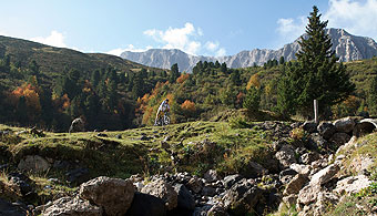
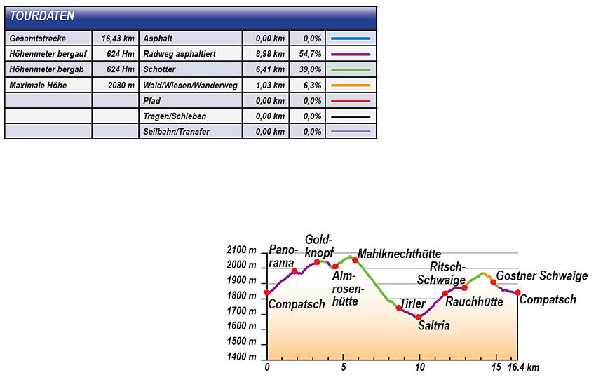
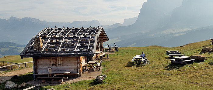
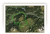
The Seiser Alm/Alpe di Siusi is Europe’s largest high pastureland. Its extensive meadows have for centuries hosted dairy-farming activities. This easy tour essentially follows the daily round of the milkmen who would visit the various farms to collect the milk produced. There is however one important difference: in those days, the milkmen had to turn back at the Mahlknecht hut, as the road ended there. Bikers can however use the new rural roads, enjoying a spectacular tour with unforgettable view over the mountains and plenty of refreshment opportunities.
The tour begins at the Tourist Information Office in Compaccio. The gradual climb up the Jochstrasse road is a perfect way to warm up; then, 380 m on from Waymarker 2, you reach the Alpenhotel Panorama. The name says it all: its location offers a 360° panorama, not just of the nearby Dolomite summits such as the Langkofel/Sasso Lungo, Plattkofel/Sasso Piatto, Marmolada, the Sella massif, Sas Rigais, Geisler/Odle group, Rosszähne/Denti di Terrarossa or the Schlern/Sciliar with the Santner Spire – on clear days you can see as far as the Zillertaler and Stubaier Alps or even the Ortler/Ortles!
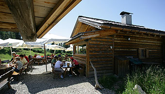
Continuing to climb, you reach the Goldknopf, the next point on the milkmen’s route. A gravel road leads to the traditional Almrosen Hut and over the highest point of the tour to the Mahlknecht Hut. This was where the rural road used to end and the milkmen would turn back. Today, the gravel road leads to the small church at Dialer. A rapid descent leads you to the next refreshment opportunity, the Almgasthof Tirler Inn. Here you can replenish your energy once more before the second long climb of the tour. An ascent of 200 m along the tarmac road from Saltria brings you to the Ritsch Schwaige Hut, with another chance to take a break. The last part of the tour then leads through the beautiful pasture landscape, pedalling across meadows up to the pass where a wonderful panorama over the Schlern/Sciliar awaits you, from the towering Rosszähne/Denti di Terrarossa to the Santner Spire. Once more through the meadows, but this time downhill, you arrive at the Gostner Schwaige Hut. The last stretch goes past the Hotel Steger Dellai to return to Compatsch, the finishing point of this short yet intensive voyage of discovery around the huts of the Seiser Alm/Alpe di Siusi.
|
| |
 |
| |
Variations
1. Extension via the Spitzbühel: a longer and more strenuous tour is possible by making a detour to the Spitzbühel. From Compaccio first descend via the Gasthaus Zorzi Inn and the Jaggl Schwaige Hut to the Spitzbühl car park. Here, climb steeply left up to the Spitzbühel and then proceed via the Laurin Hut to the Alpenhotel Panorama. Just behind the hotel, at waymarker 2, you rejoin the tour described above (+1.7 km, +190 m height variation).
2. More trails: from the Almrosen Hut you can set off along the path that leads directly to Tirler. At waymarker 8 take a slight left and follow path no. 12 to Saltria. After approximately 500 m, this path becomes a marvellous trail. At waymarker 11 you rejoin the tour described above.
3. Extension via the small church at Dialer: at waymarker 10 do not take the slight left towards Saltria, but carry on straight up to the Dialer church. Here, take a slight left towards Zallinger with the wonderful panorama of the Plattkofel/Sasso Piatto. After approximately 1.6 km take a sharp left down to Saltria. After another 1.4 km you continue to the Zallinger, following the gravel road slightly left downhill. You then rejoin the tour described above at waymarker 12 (+3.3 km, +170 m height variation). |
| |
|
| |
TOUR INFORMATION
Tour information |
|
% of distance |
Total distance |
16,43 km |
100 % |
Height variation uphill |
624 Hm |
|
Height variation downhill |
624 Hm |
|
Maximum altitude |
2080 m |
|
Tarmac |
0,00 km |
| 0,0 % |
 |
|
Tarmac cycle path |
8,98 km |
54,7 %
|
 |
|
Gravel |
6,41 km |
| 39,0 % |
 |
|
Hiking trail |
1,03 km |
6,3 %
|
 |
|
Single track |
0,00 km |
0,0 %
|
 |
|
Carrying / pushing |
0,00 km |
0,0 %
|
 |
|
Cable car / transfer |
0,00 km |
0,0 %
|
 |
|
|
| |
|
|
Riding times |
Riding time without pauses |
Riding time at 10 km/h |
1 hr 39 min |
Riding time at 12 km/h |
1 hr 22 min |
Riding time at 14 km/h |
1 hr 10 min |
Riding time at 16 km/h |
1 hr 02 min |
Riding time at 18 km/h |
55 min |
Riding time at 20 km/h |
49 min |
| |
|
| |
|
| |
|
| |
|
| |
|
|
|
| |
|
Physical condition |
|
|
Overall condition |
2,7 |
|
Total height variation |
3,0 |
|
Total distance |
2,0 |
|
Maximum altitude |
4,0 |
|
|
|
Riding technique |
|
|
Overall riding technique |
2,8 |
|
Surface |
2,5 |
|
Average climb gradient Ø |
3,0 |
|
Average descent gradient Ø |
3,0 |
|
|
|
| |
|
Tour evaluation |
|
|
Overall difficulty |
2,7 |
|
Climb difficulty |
2,7 |
|
Descent difficulty |
2,7 |
|
|
|
Emotional experience |
|
|
Panorama |
5,0 |
|
Riding fun |
3,0 |
|
| |
|
|
|
|
| |
|
GETTING THERE AND STARTING POINT
Getting there
Coming from the north:
take motorway (A22) exit for Chiusa - Alpe di Siusi, SS12 as far as Ponte Gardena, then in the direction of Alpe di Siusi.
Coming from the south:
take motorway (A22) exit for Bolzano nord - Alpe di Siusi, SS12 as far as Prato all’Isarco, then in the direction of Alpe di Siusi.
Starting point
The best place to park is the free car park of the Seiser Alm/Alpe di Siusi aerial cableway in Siusi. Then ride up with the cable car to Compaccio. The tour begins at the tourist information office in Compaccio. |
| |
ROADBOOK
No |
km |
Next |
Hm |
Sym |
Location |
Direction |
Route |
Time 22 km/h |
Time 10 km/h |
1 |
0,00 |
1,81 |
1841 |
|
Tourist information office in Compatsch/Compaccio |
Bear right to pass |
|
00:00 |
00:00 |
2 |
1,81 |
0,01 |
1980 |
|
Junction to Hotel Panorama |
Straight ahead to Goldknopf |
|
00:04 |
00:10 |
3 |
1,82 |
0,92 |
1980 |
|
Junction to Ritsch Schwaige Hut |
Straight ahead |
|
00:04 |
00:10 |
4 |
2,74 |
0,54 |
2014 |
|
Junction to Hotel Panorama |
Straight ahead uphill |
|
00:07 |
00:16 |
5 |
3,28 |
0,69 |
2041 |
|
Junction to Goldknopf |
Bear left to Saltria, Molignon Hut |
|
00:08 |
00:19 |
6 |
3,96 |
0,24 |
2041 |
|
Beginning of tarmac |
Straight ahead |
|
00:10 |
00:23 |
7 |
4,20 |
0,29 |
2007 |
|
End of tarmac |
Straight ahead |
|
00:11 |
00:25 |
8 |
4,49 |
1,29 |
2013 |
|
Almrosen Hut |
Straight ahead to Mahlknecht Hut, Dialer Hut |
|
00:12 |
00:26 |
9 |
5,78 |
0,69 |
2054 |
|
Mahlknecht Hut |
Bear left to Saltria 8 |
|
00:15 |
00:34 |
10 |
6,47 |
1,76 |
1980 |
|
Junction (bench) |
Sharp left to Saltria |
|
00:17 |
00:38 |
11 |
8,23 |
0,04 |
1778 |
|
Junction |
Straight ahead downhill |
|
00:22 |
00:49 |
12 |
8,28 |
0,37 |
1772 |
|
Intersection (sharp right to the Zallinger) |
Bear left Tirler, Saltria |
|
00:22 |
00:49 |
13 |
8,65 |
0,80 |
1740 |
|
Almgasthof Tirler Inn |
Straight ahead |
|
00:23 |
00:51 |
14 |
9,45 |
0,48 |
1701 |
|
Junction, Hans und Paula Steger Weg path |
Straight ahead on Hans und Paula Steger Weg path |
|
00:25 |
00:56 |
15 |
9,93 |
1,74 |
1678 |
|
Junction Hotel Saltria |
Left uphill to Compatsch |
|
00:27 |
00:59 |
16 |
11,68 |
0,47 |
1836 |
|
Junction towards Rauch Hut |
Bear left uphill |
|
00:31 |
01:10 |
17 |
12,15 |
0,70 |
1862 |
|
Crossroads with bus stop |
Follow road right |
|
00:33 |
01:12 |
18 |
12,85 |
0,09 |
1865 |
|
Junction |
Sharp left to Ritsch |
|
00:35 |
01:17 |
19 |
12,94 |
0,34 |
1872 |
|
Ritsch Hut |
Between hut and barn, left then right onto path no. 5 |
|
00:35 |
01:17 |
20 |
13,28 |
0,86 |
1912 |
|
Junction (grid) |
Bear left towards Schlern /Sciliar 5 |
|
00:36 |
01:19 |
21 |
14,15 |
0,39 |
1964 |
|
Junction towards pass (bench) |
Sharp left Gostner Schwaige Hut |
|
00:38 |
01:24 |
22 |
14,54 |
0,30 |
1949 |
|
Top of Steger lift |
Straight ahead to Gostner Schwaige Hut |
|
00:39 |
01:27 |
23 |
14,84 |
0,29 |
1909 |
|
Gostner Schwaige Hut |
Between house and barn on path downhill |
|
00:40 |
01:29 |
24 |
15,12 |
0,13 |
1879 |
|
Intersection with Hans & Paula Steger path |
Left towards Hotel Steger Dellai |
|
00:41 |
01:30 |
25 |
15,25 |
0,18 |
1874 |
|
Hotel Steger Dellai |
Straight ahead |
|
00:41 |
01:31 |
26 |
15,43 |
1,00 |
1856 |
|
Junction with main road |
Bear left towards Compatsch/Compaccio |
|
00:42 |
01:32 |
27 |
16,43 |
0,00 |
1841 |
|
Tourist information office in Compatsch/Compaccio |
End of tour |
|
00:44 |
01:38 |
EXPLANATION OF EVALUATION FACTORS, SURFACE AND SLOPE
Explanation of evaluation factors
• Overall difficulty based on climb difficulty (60%) and descent difficulty (40%)
• Climb difficulty based on total distance uphill (30%), overall height variation uphill (30%), surface uphill (10%), average slope uphill (25%), highest altitude reached (5%).
• Descent difficulty consists of total distance downhill (10%), overall height variation downhill (10%), surface downhill (50%), average slope downhill (30%).
• Physical condition based on total distance (40%), with overall height variation (50%) and highest altitude reached (10%).
• Riding technique based on surface (50%), with average slope uphill (30%) and average slope downhill (20%).
• Writer’s subjective evaluation of panorama and riding fun.
Explanation of surface and slope |
|
|
|
A = Tarmac road |
|
steep uphil |
from + 15% |
R = Tarmac cycle path |
|
uphill |
up to + 14% |
S = Gravel |
|
level |
ca. +/- 4% |
W = Hiking trail |
|
downhill |
up to - 19% |
P = Path, Single Trail |
|
steep downhill |
from - 20% |
T = Carrying / pushing |
|
|
|
X = Cable car / transfer |
|
|
|
Route: the percentages indicate the average climb (+) or the average descent (-) to the next waymarker. |
DOWNLOADS
| |
 |
 |
 |
 |
CHARACTERISTICS |
ALTITUDE PROFILE |
ROADBOOK |
MAP |
|
| |
|