|
CHARACTERISTICS AND VARIATIONS
Characteristics
Alternative to the Gardena valley tour with a visit to the Sankt Jakob church, the oldest church in the valley. It dates from the 17th century and features frescoes on the south façade well worth seeing. The second part of the tour takes place on gloriously secluded secondary roads and woodland trails with surprisingly funny trails between Insom and Annatal (Anna valley). There the guest house Annatal, an idyllic stop for refreshments in a stunning location, is waiting for thirsty bikers.
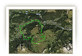
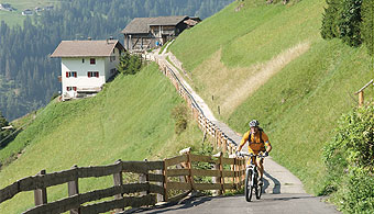
It starts at the tourism association in St. Ulrich. You now ride uphill for just under ten kilometres on a steady moderate even climb. The route follows the course of the Gardena valley tour via St. Christina as far as Wolkenstein and where it is allowed it uses the former railway line that is very pleasant to cycle along.
From the centre of Wolkenstein it gets momentarily a little steeper until you reach the mouth of the Langental that is already in the Puez-Geisler nature park. Whoever wants to can extend the tour with a detour into the upper Langental (s. variations). At the car park in the Langental the tour takes a south-westerly turn. Still above the main road the tour leads via La Pozza to the valley station of the Col Raiser cable car.
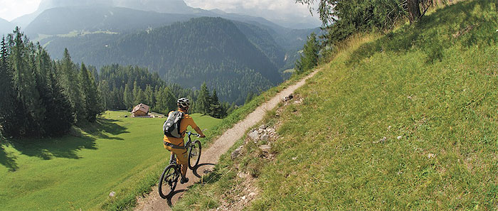
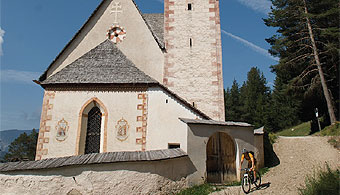
The most beautiful part of the tour begins here. Via the secluded hamlet of Insom you go in the direction of Sankt Jakob, still somewhat above and away from the hustle and bustle of the valley. The trail becomes ever narrower and gives a lot of pleasure well before reaching the church.
The small church of Sankt Jakob with its distinctive tower, its contemplative cemetery and its lovely frescoes is located in a stunning spot overlooking the valley. Bikers enjoy this on the spacious sunbathing lawn next to the church with a view that stretches as far as the Plattkofel, Langkofel and the Sella mountain range. There then follow three kilometres of sheer riding fun on the narrow woodland trail leading to the Annatal. Still in woodland handkerchief-wide trails alternate with wide woodland trails, switchbacks and small wooden bridges and make you wish it would stay like this forever.
Unfortunately, the trails end at the Pauli mountain cabin. It is only a few metres still to the well-tended Annatal mountain cabin, the ideal stop for refreshments on this tour. Tables in the shade or sun loungers in the sun invite you to relax to the full. Or you can cool your heated feet in the stream behind the sunbathing lawn.
After refreshments you roll along, almost only downhill, past the valley station of the Seceda cable car back to the centre of St. Ulrich.
|
| |
 |
| |
Variations
1. Extension into the Langental: waymarker 41 is the ideal place to extend the tour into the upper Langental. Simply continue straight ahead and keep following the cross-country ski run as far as Pra da Ri mountain pasture. In this way, you add 7.2 km and 230 m in altitude difference to the tour.
2. Leaving out Wolkenstein and Langental: if you do not turn right onto the former railway line at waymarker 26, but bear left up to the road, you save 6.6 km and 175 m in altitude difference. You continue the tour at waymarker 51.
3. On the other side of the valley from St. Ulrich to Wolkenstein: In St. Ulrich take the pedestrian bridge to the valley station of the Seiser Alm cable car. Go left uphill before the valley station and along the promenade of rio Gardena. Now continue to follow the course of the Gardena valley tour in the opposite direction. In this way, you arrive at the starting point at the tourism association in Wolkenstein. A few metres further straight ahead on the main road, you join the tour described here at waymarker 34. |
| |
|
| |
TOUR INFORMATION
Tour information |
|
% of distance |
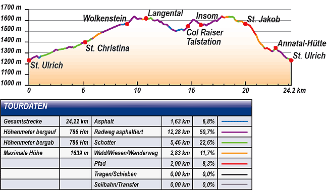
Total distance |
24,22 km |
100 % |
Height variation uphill |
786 Hm |
|
Height variation downhill |
786 Hm |
|
Maximum altitude |
1639 m |
|
Tarmac |
1,63 km |
| 6,8 % |
 |
|
Tarmac cycle path |
12,28 km |
50,7 %
|
 |
|
Gravel |
5,46 km |
| 22,6 % |
 |
|
Hiking trail |
2,83 km |
11,7 %
|
 |
|
Single track |
2,00 km |
8,3 %
|
 |
|
Carrying / pushing |
0,00 km |
0,0 %
|
 |
|
Cable car / transfer |
0,00 km |
0,0 %
|
 |
|
|
| |
|
|
Riding times |
Riding time without pauses |
Riding time at 10 km/h |
2 hrs 25 min |
Riding time at 12 km/h |
2 hrs 01 min |
Riding time at 14 km/h |
1 hr 44 min |
Riding time at 16 km/h |
1 hr 31 min |
Riding time at 18 km/h |
1 hr 21 min |
Riding time at 20 km/h |
1 hr 13 min |
| |
|
| |
|
| |
|
| |
|
| |
|
|
|
| |
|
Physical condition |
|
|
Overall condition |
3,0 |
|
Total height variation |
3,0 |
|
Total distance |
3,0 |
|
Maximum altitude |
3,0 |
|
|
|
Riding technique |
|
|
Overall riding technique |
2,8 |
|
Surface |
3,1 |
|
Average climb gradient Ø |
2,0 |
|
Average descent gradient Ø |
3,0 |
|
|
|
| |
|
Tour evaluation |
|
|
Overall difficulty |
3,0 |
|
Climb difficulty |
2,7 |
|
Descent difficulty |
3,4 |
|
|
|
Emotional experience |
|
|
Panorama |
3,0 |
|
Riding fun |
3,0 |
|
| |
|
|
|
|
| |
|
GETTING THERE AND STARTING POINT
Getting there
Take Brenner motorway A22, coming from the north via Innsbruck-Brenner, or from the south via Verona-Bozen.
The best motorway exit is Klausen/Gröden. From there in about 20 minutes you can reach St Ulrich and a few kilometres further on St. Christina and Wolkenstein on a clearly signposted mountain road.
Starting point
The tour begins at the tourism association in St. Ulrich.
There are parking facilities at the valley station of the Seceda cable car. |
| |
ROADBOOK
No |
km |
Next |
Hm |
Sym |
Location |
Direction |
Route |
Time 22 km/h |
Time 10 km/h |
1 |
0,00 |
0,08 |
1231 |
|
Tourist information office in
St. Ulrich/Ortisei |
Right to St. Jakob/San Giacomo |
|
00:00 |
00:00 |
2 |
0,08 |
0,04 |
1236 |
|
Church of St. Ulrich/Ortisei |
Bear right after church |
|
00:00 |
00:00 |
3 |
0,13 |
0,60 |
1239 |
|
Pana car park |
Straight on (left past the car park entrance) |
|
00:00 |
00:00 |
4 |
0,73 |
0,20 |
1273 |
|
Junction streda Paul Grohmann |
Straight on downhill |
|
00:01 |
00:04 |
5 |
0,92 |
0,20 |
1253 |
|
Otco Sculptures |
Bear left to S. Cristina |
|
00:02 |
00:05 |
6 |
1,12 |
1,15 |
1270 |
|
Zebra crossing |
Bear right to S. Cristina |
|
00:03 |
00:06 |
7 |
2,27 |
0,22 |
1314 |
|
End of gravel path |
Straight on |
|
00:06 |
00:13 |
8 |
2,48 |
0,22 |
1330 |
|
Intersection in front of Hotel Diamant |
Bear right along zebra crossing |
|
00:06 |
00:14 |
9 |
2,71 |
0,57 |
1327 |
|
Crossing with main road |
Bear left to S. Cristina |
|
00:07 |
00:16 |
10 |
3,28 |
0,21 |
1340 |
|
Haus Alba |
Straight on over the zebra crossing |
|
00:08 |
00:19 |
11 |
3,49 |
0,28 |
1343 |
|
Spar |
Bear left to S. Cristina |
|
00:09 |
00:20 |
12 |
3,77 |
0,26 |
1356 |
|
Crossing with main road |
Straight on Str. Plan dala Sia |
|
00:10 |
00:22 |
13 |
4,03 |
0,06 |
1355 |
|
Hofer Group |
Bear right downhill |
|
00:10 |
00:24 |
14 |
4,09 |
0,77 |
1349 |
|
Bridge over stream (towards waterfall) |
Straight on (no through road) |
|
00:11 |
00:24 |
15 |
4,87 |
0,29 |
1389 |
|
Bottom of Monte Pana chairlift |
Straight on along stream |
|
00:13 |
00:29 |
16 |
5,15 |
0,04 |
1399 |
|
Junction before subway under main road |
Straight on through subway |
|
00:14 |
00:30 |
17 |
5,19 |
0,13 |
1399 |
|
Bridge (towards Val Gardena Marketing in S. Cristina) |
Straight on |
|
00:14 |
00:31 |
18 |
5,33 |
0,13 |
1405 |
|
Intersection |
Bear right to bottom of lift |
|
00:14 |
00:31 |
19 |
5,45 |
0,29 |
1409 |
|
Junction with bottom of Sasslong lift |
Bear right towards subway |
|
00:14 |
00:32 |
20 |
5,75 |
0,08 |
1432 |
|
Intersection |
Bear right along stream |
|
00:15 |
00:34 |
21 |
5,83 |
0,11 |
1430 |
|
Wooden bridge |
Bear right over bridge (residents access) |
|
00:15 |
00:34 |
22 |
5,94 |
0,43 |
1438 |
|
Crossroads |
Straight on along stream |
|
00:16 |
00:35 |
23 |
6,36 |
0,35 |
1471 |
|
Junction with hiking trail |
Straight on to Wolkenstein/Selva |
|
00:17 |
00:38 |
24 |
6,71 |
0,12 |
1487 |
|
Haus Paladina |
Left towards main road |
|
00:18 |
00:40 |
25 |
6,83 |
0,15 |
1489 |
|
Bar Adelaide, Crossing with main road |
Straight on Strada La Poza |
|
00:18 |
00:40 |
26 |
6,98 |
0,15 |
1500 |
|
Crossing with course of old railway |
Right |
|
00:19 |
00:41 |
27 |
7,14 |
0,28 |
1505 |
|
Crossing at Haus Lambolt |
Straight on over the zebra crossing |
|
00:19 |
00:42 |
28 |
7,42 |
0,58 |
1518 |
|
Crossing at Hotel Welponer |
Straight on to Wolkenstein/Selva |
|
00:20 |
00:44 |
29 |
8,00 |
0,48 |
1542 |
|
Hotel Sporting |
Straight on over road and follow cycle path |
|
00:21 |
00:47 |
30 |
8,48 |
0,08 |
1561 |
|
End of cycle path |
Straight on |
|
00:23 |
00:50 |
31 |
8,56 |
0,10 |
1562 |
|
Villa Gran Baita |
Straight on |
|
00:23 |
00:51 |
32 |
8,67 |
0,29 |
1561 |
|
Wolkenstein/Selva primary school |
Straight on strada Nives |
|
00:23 |
00:51 |
33 |
8,95 |
0,11 |
1569 |
|
Pizzaealtro |
Bear right onto main road |
|
00:24 |
00:53 |
34 |
9,06 |
0,04 |
1566 |
|
Hotel Krone in Wolkenstein/Selva |
Straight on main road |
|
00:24 |
00:54 |
35 |
9,10 |
0,09 |
1567 |
|
Junction with Str. Dantercepies |
Sharp left Langental/Vallunga |
|
00:24 |
00:54 |
36 |
9,18 |
0,16 |
1577 |
|
Hotel Sun Valley |
Straight on |
|
00:25 |
00:55 |
37 |
9,34 |
0,37 |
1593 |
|
Junction towards Langental/Vallunga |
Straight on to Dantercepies |
|
00:25 |
00:56 |
38 |
9,72 |
0,31 |
1635 |
|
Junction towards bottom of Dantercepies lift |
Bear left to Langental/Vallunga |
|
00:26 |
00:58 |
39 |
10,03 |
0,42 |
1610 |
|
Junction |
Bear right to Vallunga, cross-country ski trail |
|
00:27 |
01:00 |
40 |
10,45 |
0,37 |
1611 |
|
Ciampec Hut |
Right straight on to Langental/Vallunga |
|
00:28 |
01:02 |
41 |
10,82 |
0,62 |
1618 |
|
Imbiss La Ciajota snack-bar, car park |
Bear right (St. Silvester chapel) |
|
00:29 |
01:04 |
42 |
11,45 |
0,19 |
1602 |
|
Junction to café, snack-bar, VAL |
Bear right to Wolkenstein/Selva |
|
00:31 |
01:08 |
43 |
11,64 |
0,71 |
1597 |
|
Junction towards bottom of Dantercepies lift |
Straight on S. Cristina |
|
00:31 |
01:09 |
44 |
12,35 |
0,40 |
1572 |
|
Junction Str. Larciunei |
Bear right to Str. Col da Lech |
|
00:33 |
01:14 |
45 |
12,75 |
0,02 |
1559 |
|
Haus Templa |
Straight on |
|
00:34 |
01:16 |
46 |
12,77 |
0,17 |
1557 |
|
Near Haus Templa |
Straight on str. Rainel |
|
00:34 |
01:16 |
47 |
12,94 |
0,24 |
1541 |
|
Roundabout |
Right to S. Cristina |
|
00:35 |
01:17 |
48 |
13,18 |
0,28 |
1518 |
|
Crossing at Hotel Welponer |
Bear right on cycle path |
|
00:35 |
01:19 |
49 |
13,46 |
0,15 |
1505 |
|
Crossing at Haus Lambolt |
Straight on over the zebra crossing |
|
00:36 |
01:20 |
50 |
13,62 |
0,03 |
1500 |
|
Crossroads |
Bear right up to main road |
|
00:37 |
01:21 |
51 |
13,64 |
0,53 |
1505 |
|
Intersection with main road, Mick Carpentry shop |
Bear left |
|
00:37 |
01:21 |
52 |
14,17 |
0,14 |
1516 |
|
Small chapel, zebra crossing |
Bear right 83-85 |
|
00:38 |
01:25 |
53 |
14,31 |
0,38 |
1505 |
|
Garni Pramaura |
Bear right uphill to Col Raiser |
|
00:39 |
01:25 |
54 |
14,68 |
0,44 |
1546 |
|
Bottom of Col Raiser lift |
Straight on uphill |
|
00:40 |
01:28 |
55 |
15,13 |
0,08 |
1605 |
|
Subway |
Straight on Str. Insom (through subway) |
|
00:41 |
01:30 |
56 |
15,21 |
0,02 |
1605 |
|
Crossing (towards Pramulin Hut) |
Straight on over bridge |
|
00:41 |
01:31 |
57 |
15,23 |
0,66 |
1606 |
|
Intersection after bridge |
Left downhill |
|
00:41 |
01:31 |
58 |
15,89 |
0,15 |
1558 |
|
Insom |
Straight on to S. Cristina |
|
00:43 |
01:35 |
59 |
16,04 |
0,21 |
1556 |
|
Junction towards the centre of
S. Cristina |
Straight on to church in
S. Cristina |
|
00:43 |
01:36 |
60 |
16,25 |
0,13 |
1561 |
|
Hydrant |
Left downhill |
|
00:44 |
01:37 |
61 |
16,38 |
0,06 |
1551 |
|
Intersection |
Straight on to Prauletta |
|
00:44 |
01:38 |
62 |
16,44 |
0,60 |
1558 |
|
Junction with Str. Col da Messa |
Straight on uphill to St. Jakob/San Giacomo |
|
00:44 |
01:38 |
63 |
17,04 |
0,31 |
1591 |
|
Junction to Seceda |
Straight on to St. Jakob/San Giacomo |
|
00:46 |
01:42 |
64 |
17,36 |
0,46 |
1591 |
|
Junction to Uleta |
Bear right to church of St. Jakob/San Giacomo 32 |
|
00:47 |
01:44 |
65 |
17,82 |
0,34 |
1639 |
|
Chapel |
Left to church of St. Jakob/San Giacomo |
|
00:48 |
01:46 |
66 |
18,16 |
0,14 |
1629 |
|
Junction 20m after wayside cross |
Straight on to St. Jakob/San Giacomo |
|
00:49 |
01:48 |
67 |
18,30 |
0,17 |
1635 |
|
Crossing (towards Seceda) |
Straight on to St. Jakob/San Giacomo |
|
00:49 |
01:49 |
68 |
18,48 |
0,44 |
1635 |
|
Intersection with gravel road |
Bear left towards St. Jakob/San Giacomo |
|
00:50 |
01:50 |
69 |
18,92 |
0,14 |
1627 |
|
Junction to Seurasas |
Straight on to St. Jakob/San Giacomo |
|
00:51 |
01:53 |
70 |
19,06 |
0,21 |
1604 |
|
Junction towards St. Ulrich/Ortisei |
Straight on to church of St. Jakob/San Giacomo |
|
00:51 |
01:54 |
71 |
19,27 |
0,22 |
1590 |
|
Intersection with gravel road |
Bear right to church of St. Jakob/San Giacomo |
|
00:52 |
01:55 |
72 |
19,49 |
0,47 |
1589 |
|
End of gravel road |
Straight on |
|
00:53 |
01:56 |
73 |
19,96 |
0,02 |
1565 |
|
Fountain in front of church |
Straight on |
|
00:54 |
01:59 |
74 |
19,98 |
0,03 |
1567 |
|
Church of St. Jakob/San Giacomo |
Straight on |
|
00:54 |
01:59 |
75 |
20,01 |
0,30 |
1564 |
|
Junction to Sacun |
Straight on to Col de Flam |
|
00:54 |
02:00 |
76 |
20,31 |
0,69 |
1557 |
|
Crossroads |
Straight on to St. Ulrich/Ortisei |
|
00:55 |
02:01 |
77 |
20,99 |
0,66 |
1463 |
|
Junction with track |
Sharp right downhill |
|
00:57 |
02:05 |
78 |
21,65 |
0,08 |
1359 |
|
Junction |
Sharp right St. Ulrich/Ortisei 6 |
|
00:59 |
02:09 |
79 |
21,73 |
0,68 |
1347 |
|
Water source |
Straight on between benches to Val d’Anna |
|
00:59 |
02:10 |
80 |
22,41 |
0,01 |
1317 |
|
Pauli Hut |
Left downhill |
|
01:01 |
02:14 |
81 |
22,43 |
0,19 |
1315 |
|
Tree with wayside cross |
Sharp right |
|
01:01 |
02:14 |
82 |
22,62 |
0,05 |
1324 |
|
Bridge |
Straight on |
|
01:01 |
02:15 |
83 |
22,67 |
0,12 |
1332 |
|
Junction |
Bear right towards guesthouse |
|
01:01 |
02:16 |
84 |
22,79 |
0,12 |
1346 |
|
Annatal Hut |
Turn back |
|
01:02 |
02:16 |
85 |
22,91 |
0,05 |
1332 |
|
Junction |
Bear left towards bridge |
|
01:02 |
02:17 |
86 |
22,97 |
0,19 |
1324 |
|
Bridge |
Straight on |
|
01:02 |
02:17 |
87 |
23,16 |
0,21 |
1315 |
|
Tree with wayside cross (towards Pauli Hut) |
Bear right downhill |
|
01:03 |
02:18 |
88 |
23,37 |
0,52 |
1298 |
|
Playground |
Straight on downhill |
|
01:03 |
02:20 |
89 |
23,89 |
0,18 |
1251 |
|
Bottom of Seceda lift |
Straight on downhill |
|
01:05 |
02:23 |
90 |
24,07 |
0,07 |
1243 |
|
Intersection with tarmac road (stone) |
Bear right downhill towards church |
|
01:05 |
02:24 |
91 |
24,14 |
0,08 |
1236 |
|
Church of St. Ulrich/Ortisei |
Straight on to tourist information office |
|
01:05 |
02:24 |
92 |
24,22 |
0,00 |
1231 |
|
Tourist information office in
St. Ulrich/Ortisei |
End of tour |
|
01:06 |
02:25 |
EXPLANATION OF EVALUATION FACTORS, SURFACE AND SLOPE
Explanation of evaluation factors
• Overall difficulty based on climb difficulty (60%) and descent difficulty (40%)
• Climb difficulty based on total distance uphill (30%), overall height variation uphill (30%), surface uphill (10%), average slope uphill (25%), highest altitude reached (5%).
• Descent difficulty consists of total distance downhill (10%), overall height variation downhill (10%), surface downhill (50%), average slope downhill (30%).
• Physical condition based on total distance (40%), with overall height variation (50%) and highest altitude reached (10%).
• Riding technique based on surface (50%), with average slope uphill (30%) and average slope downhill (20%).
• Writer’s subjective evaluation of panorama and riding fun.
Explanation of surface and slope |
|
|
|
A = Tarmac road |
|
steep uphill |
from + 15% |
R = Tarmac cycle path |
|
uphill |
up to + 14% |
S = Gravel |
|
level |
ca. +/- 4% |
W = Hiking trail |
|
downhill |
up to - 19% |
P = Path, Single Trail |
|
steep downhill |
from - 20% |
T = Carrying / pushing |
|
|
|
X = Cable car / transfer |
|
|
|
Route: the percentages indicate the average climb (+) or the average descent (-) to the next waymarker. |
DOWNLOADS
| |
 |
 |
 |
 |
CHARACTERISTICS |
ALTITUDE PROFILE |
ROADBOOK |
MAP |
|
| |
|

