|
CHARACTERISTICS AND VARIATIONS
Characteristics
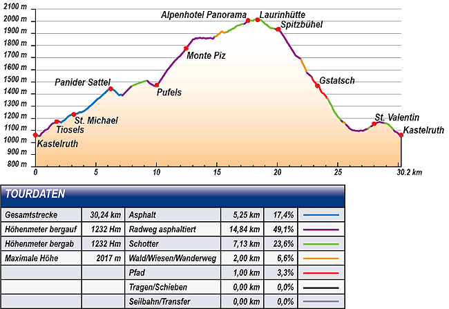
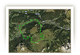
The tour to the Laurin Hut combines intensive fitness training uphill with glorious Dolomite panoramas from the the balcony seats of the Alpe di Siusi and more challenging riding technique downhill.
The tour begins in the centre of Castelrotto immediately next to the tower. You can warm up in the first few kilometres of a lightly trafficked side road to Tiosels. Shortly after Tiosels you join the road leading to Val Gardena. It is best to cover the next five kilometres as far as the Passo Pinei as quickly as possible. Unfortunately, there is no alternative to the main road here for bikers. From Passo Pinei you go downhill for a short time before climbing a narrow side road leading to Bulla/Pufels. The beautiful old gravel road that leads directly to the road in Bulla again by-passes the recently built tunnel.
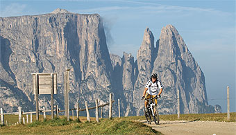
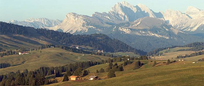
Now for something a bit steeper, but still pleasant to ride, you pedal up over Monte Piz to the Alpe di Siusi. Follow the road for a short distance in the direction of Compaccio, then past Hotel Steger Dellai turn off onto the gravel alternative leading to the Alpenhotel Panorama. Already on this section, views of the Denti di Terrarossa/Rosszähne, the first foothills of the Catinaccio/Rosengarten in the south and the Sciliar/Schlern will inspire you.
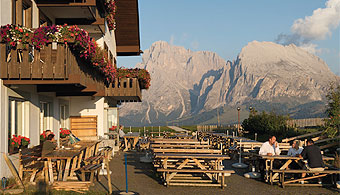
The uphill marathon is finished once you reach the Alpenhotel Panorama. For more than 17 kilometres you have gone almost solely uphill, climbing a good 1,100m in altitude. Up here three fantastic refreshment facilities court the favour of thirsty and hungry bikers: the Alpenhotel Panorama with its unforgettable 360° panoramic view, the original and unspoilt Laurin hut with its perfect view of the Sciliar/Schlern, or the Spitzbühel that soars above the valley like an eagle's eyrie and from where the Sciliar/Schlern seems to be close enough to touch.
In any event, you will need some refreshment, because on reaching the car park at Spitzbühel the tour changes its character decisively. If up until now fitness has mainly been needed, now riding technique is called for. The trail leading to Gstatsch is challenging. It is narrow, calls for technique, as it was a former cart path in parts. Take care: when it is wet or raining it can be very slippery.
From Gstatsch the downhill fun goes on. A narrow, lonely trail circles down in the direction of Bagni di Razzes. Only after crossing the Frommer stream do you come across civilisation again in the form of a gravel road.
Small side roads, partially closed to traffic, lead finally via Bagni di Razzes and above Siusi to San Costantino and back to Castelrotto.
|
| |
 |
| |
Variations
1. Easier downhill: whoever finds descending the trails too difficult can “drop out” at waymarkers 43, 45 or 48 and simply descend on the Alpe di Siusi road. Anyway in San Valentino at waymarker 68 you join the tour described here.
2. Easier tour: the tour can be shortened at waymarker 21 by simply continuing straight ahead in the direction of Compaccio. A little below you join the tour described here again at the car park Spitzbühel (waymarker 41). Admittedly, you miss the most beautiful views of the tour up on the Alpe di Siusi.
3. Longer tour: the tour can be extended easily on the Alpe di Siusi to meet your wishes. One possibility is after the ascent not to bear right at waymarker 20 to Compaccio, but to turn sharp left to Saltria and from there via Malga Tirler and the Almrosen Hut in the direction of the Alpenhotel Panorama. A short distance before the hotel, you joint the tour described here at waymarker 25. |
| |
|
| |
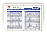
TOUR INFORMATION
Tour information |
|
% of distance |
Total distance |
30,24 km |
100 % |
Height variation uphill |
1232 Hm |
|
Height variation downhill |
1232 Hm |
|
Maximum altitude |
2017 m |
|
Tarmac |
5,25 km |
| 17,4 % |
 |
|
Tarmac cycle path |
14,84 km |
49,1 %
|
 |
|
Gravel |
7,13 km |
| 23,6 % |
 |
|
Hiking trail |
2,00 km |
6,6 %
|
 |
|
Single track |
1,00 km |
3,3 %
|
 |
|
Carrying / pushing |
0,00 km |
0,0 %
|
 |
|
Cable car / transfer |
0,00 km |
0,0 %
|
 |
|
|
| |
|
|
Riding times |
Riding time without pauses |
Riding time at 10 km/h |
3 hrs 01 min |
Riding time at 12 km/h |
2 hrs 31 min |
Riding time at 14 km/h |
2 hrs 10 min |
Riding time at 16 km/h |
1 hr 53 min |
Riding time at 18 km/h |
1 hr 41 min |
Riding time at 20 km/h |
1 hr 31 min |
| |
|
| |
|
| |
|
| |
|
| |
|
|
|
| |
|
Physical condition |
|
|
Overall condition |
3,6 |
|
Total height variation |
4,0 |
|
Total distance |
3,0 |
|
Maximum altitude |
4,0 |
|
|
|
Riding technique |
|
|
Overall riding technique |
3,0 |
|
Surface |
2,6 |
|
Average climb gradient Ø |
3,0 |
|
Average descent gradient Ø |
4,0 |
|
|
|
| |
|
Tour evaluation |
|
|
Overall difficulty |
3,3 |
|
Climb difficulty |
3,3 |
|
Descent difficulty |
3,4 |
|
|
|
Emotional experience |
|
|
Panorama |
5,0 |
|
Riding fun |
4,0 |
|
| |
|
|
|
|
| |
|
GETTING THERE AND STARTING POINT
Getting there
Coming from the north take the motorway (A22) exit for Chiusa – Alpe di Siusi/Sciliar, SS12 as far as Ponte Gardena, then in the direction of Alpe di Siusi.
Coming from the south take motorway (A22) exit for Bolzano Nord – Alpe di Siusi/Sciliar, SS12 as far as Prato all'Isarco, then in the direction of Alpe di Siusi.
Starting point
There are several car parks and underground parking facilities in all villages. Parking spaces marked in blue are subject to charges. Tickets are available from the appropriate automatic machines. All other parking spaces are free of charge.
The tour begins at the tourism association in Castelrotto.
|
| |
ROADBOOK
No |
km |
Next |
Hm |
Sym |
Location |
Direction |
Route |
Time 22 km/h |
Time 10 km/h |
1 |
0,00 |
0,07 |
1062 |
|
Tourism association Castelrotto |
Straight ahead between Castelrotto’s tower and fountain |
|
00:00 |
00:00 |
2 |
0,07 |
0,06 |
1059 |
|
Hotel zum Wolf |
Bear right |
|
00:00 |
00:00 |
3 |
0,13 |
0,20 |
1061 |
|
Sparkasse Kastelruth |
Left San Michele |
|
00:00 |
00:00 |
4 |
0,33 |
0,78 |
1052 |
|
Konsum-Markt |
Bear right St. Michael (San Michele) 7 |
|
00:00 |
00:01 |
5 |
1,11 |
0,29 |
1121 |
|
Fork right to St. Michael (San Michele) 7 |
Bear left |
|
00:03 |
00:06 |
6 |
1,41 |
0,35 |
1155 |
|
Junction to Seis (Siusi) 7 |
Bear left St. Michael (San Michele) 7 |
|
00:03 |
00:08 |
7 |
1,76 |
0,36 |
1173 |
|
Maso / Unterdill Hof in Tiosels |
Straight ahead |
|
00:04 |
00:10 |
8 |
2,12 |
0,17 |
1165 |
|
Junction main road |
Right uphill |
|
00:05 |
00:12 |
9 |
2,29 |
0,90 |
1177 |
|
Junction to Wasserebene |
Straight ahead uphill |
|
00:06 |
00:13 |
10 |
3,19 |
1,12 |
1232 |
|
Maso Ritsch Hof in San Michele (junction to Schafstall) |
Straight ahead |
|
00:08 |
00:19 |
11 |
4,31 |
1,92 |
1280 |
|
Church San Michele |
Straight ahead |
|
00:11 |
00:25 |
12 |
6,23 |
0,96 |
1443 |
|
Passo Pinei 1437 m |
Straight ahead |
|
00:16 |
00:37 |
13 |
7,18 |
0,53 |
1387 |
|
Hotel Albion |
Bear right uphill Bulla |
|
00:19 |
00:43 |
14 |
7,72 |
0,26 |
1441 |
|
Junction old road to Bulla |
Sharp right uphill |
|
00:21 |
00:46 |
15 |
7,98 |
1,27 |
1467 |
|
Bend (end of tarmac) |
Straight ahead |
|
00:21 |
00:47 |
16 |
9,25 |
0,79 |
1510 |
|
Junction |
Bear right |
|
00:25 |
00:55 |
17 |
10,04 |
2,42 |
1473 |
|
Bulla |
Bear right uphill Alpe di Siusi |
|
00:27 |
01:00 |
18 |
12,47 |
1,00 |
1777 |
|
Hotel Monte Piz |
Straight ahead |
|
00:33 |
01:14 |
19 |
13,47 |
0,14 |
1862 |
|
Junction |
Bear right |
|
00:36 |
01:20 |
20 |
13,61 |
1,07 |
1864 |
|
Junction main road |
Bear right Compaccio |
|
00:37 |
01:21 |
21 |
14,68 |
0,18 |
1856 |
|
Crossroad |
Sharp left Hans und Paula Steger Weg 3 |
|
00:40 |
01:28 |
22 |
14,86 |
0,13 |
1874 |
|
Hotel Steger Dellai |
Straight ahead |
|
00:40 |
01:29 |
23 |
14,99 |
0,90 |
1879 |
|
Junction Malga Gostner Schwaige |
Straight ahead Hans und Paula Steger Weg |
|
00:40 |
01:29 |
24 |
15,89 |
1,39 |
1912 |
|
Crossroad |
Bear right Schlern (Sciliar) 5 |
|
00:43 |
01:35 |
25 |
17,27 |
0,01 |
1980 |
|
Junction tarmac road |
Right |
|
00:47 |
01:43 |
26 |
17,29 |
0,29 |
1980 |
|
Junction |
Sharp left
Gasthof Panorama |
|
00:47 |
01:43 |
27 |
17,85 |
0,08 |
2007 |
|
Alpenhotel Panorama |
Bear left |
|
00:47 |
01:45 |
28 |
17,65 |
0,03 |
2011 |
|
Mountain station Panorama |
Straight ahead |
|
00:48 |
01:45 |
29 |
17,68 |
0,50 |
2011 |
|
Junction Tierser Alpl (Rifugio Alpe di Tires) 2 |
Straight ahead Spitzbühel |
|
00:49 |
01:46 |
30 |
18,18 |
0,19 |
2015 |
|
Junction Sattler Schweige |
Right Spitzbühel |
|
00:50 |
01:49 |
31 |
18,37 |
0,27 |
2013 |
|
Laurin hut |
Left |
|
00:50 |
01:50 |
32 |
18,64 |
0,56 |
2012 |
|
Junction Sattler Schweige |
Bear right Spitzbühel |
|
00:52 |
01:51 |
33 |
19,20 |
0,09 |
1964 |
|
Junction |
Bear right Spitzbühel |
|
00:37 |
01:55 |
34 |
19,29 |
0,53 |
1957 |
|
Seat, table |
Straight ahead Spitzbühel |
|
00:52 |
01:55 |
35 |
19,82 |
0,09 |
1939 |
|
Junction to the Schlernhaus / Rifugio Bolzano |
Bear right Spitzbühel |
|
00:54 |
01:58 |
36 |
19,91 |
0,09 |
1933 |
|
Junction |
Straight downhill |
|
00:54 |
01:59 |
37 |
19,99 |
0,11 |
1921 |
|
Junction |
Bear left Spitzbühel |
|
00:54 |
01:59 |
38 |
20,11 |
0,11 |
1935 |
|
Spitzbühel |
Back |
|
00:54 |
02:00 |
39 |
20,22 |
0,93 |
1921 |
|
Junction tarmac road |
Left downhill |
|
00:55 |
02:01 |
40 |
21,14 |
0,50 |
1777 |
|
Junction gravel road |
Straight ahead downhill |
|
00:57 |
02:06 |
41 |
21,64 |
0,20 |
1710 |
|
Bend car park Spitzbühel, bus stop |
Bear left downhill Alpe di Siusi road |
|
00:59 |
02:09 |
42 |
21,84 |
0,10 |
1696 |
|
Junction to Marinzen refuge (small car park)
|
Straight ahead |
|
00:59 |
02:11 |
43 |
21,94 |
0,50 |
1688 |
|
Junction |
Bear left Castelrotto, Seis (Siusi) 4 |
|
00:59 |
02:11 |
44 |
22,45 |
0,40 |
1575 |
|
Crossroad |
Sharp left Alpe di Siusi road |
|
01:01 |
02:14 |
45 |
22,84 |
0,37 |
1542 |
|
Junction |
Bear left downhill 4 |
|
01:02 |
02:17 |
46 |
23,21 |
0,10 |
1481 |
|
Junction single track |
Straight ahead downhill |
|
01:03 |
02:19 |
47 |
23,31 |
0,18 |
1469 |
|
Gstatsch |
Sharp left downhill Alpe di Siusi road |
|
01:03 |
02:19 |
48 |
23,49 |
0,08 |
1457 |
|
Bend 3 |
Left Bagni di Razzes |
|
01:04 |
02:20 |
49 |
23,57 |
0,51 |
1433 |
|
Crossroads riding trail |
Left |
|
01:04 |
02:21 |
50 |
24,08 |
0,04 |
1368 |
|
Junction hiking trail |
Bear Left Bagni di Razzes 9 |
|
01:05 |
02:24 |
51 |
24,12 |
0,09 |
1364 |
|
Bridge over brook |
Right cross bridge over brook |
|
01:05 |
02:24 |
52 |
24,22 |
0,58 |
1353 |
|
Junction gravel road |
Right |
|
01:06 |
02:25 |
53 |
24,79 |
0,23 |
1244 |
|
Junction hiking trail to Bagni di Razzes |
Straight ahead |
|
01:07 |
02:28 |
54 |
25,02 |
0,14 |
1210 |
|
Junction in bend (nature park boundary) |
Sharp left downhill |
|
01:08 |
02:30 |
55 |
25,16 |
0,12 |
1197 |
|
Crossroad |
Bear right downhill |
|
01:08 |
02:30 |
56 |
25,28 |
0,18 |
1182 |
|
Junction Ratzesweg (Bank/seat) |
Bear right downhill |
|
01:08 |
02:31 |
57 |
25,46 |
0,09 |
1167 |
|
Junction |
Bear left level road |
|
01:09 |
02:32 |
58 |
25,55 |
0,13 |
1165 |
|
Fork water reservoir |
Bear right Seis (Siusi) 1 |
|
01:10 |
02:33 |
59 |
25,68 |
0,40 |
1148 |
|
Junction road |
Bear left downhill |
|
01:11 |
02:34 |
60 |
26,08 |
0,11 |
1109 |
|
Junction to Siusi cable car |
Straight ahead downhill |
|
01:11 |
02:36 |
61 |
26,19 |
0,33 |
1102 |
|
Wooden bridge |
Right over bridge |
|
01:04 |
02:37 |
62 |
26,53 |
0,54 |
1097 |
|
Junction to Bad Ratzes (Bagni di Razzes) 6 |
Bear left Kastelruth (Castelrotto) 6 |
|
01:12 |
02:39 |
63 |
27,07 |
0,16 |
1095 |
|
Crossroads way of the cross |
Straight ahead Kastelruth (Castelrotto) 6 |
|
01:13 |
02:42 |
64 |
27,23 |
0,27 |
1105 |
|
Junction |
Bear left Kastelruth (Castelrotto) 6 |
|
01:14 |
02:43 |
65 |
27,50 |
0,26 |
1115 |
|
Private car park |
Straight ahead |
|
01:14 |
02:44 |
66 |
27,76 |
0,26 |
1134 |
|
Patener Hof |
Bear right Kastelruth (Castelrotto) 6 |
|
01:15 |
02:46 |
67 |
28,01 |
0,08 |
1155 |
|
Junction Alpe di Siusi road |
Sharp right uphill |
|
01:16 |
02:48 |
68 |
28,08 |
0,12 |
1159 |
|
Junction |
Left Maso Psoar Hof |
|
01:16 |
02:48 |
69 |
28,21 |
0,70 |
1160 |
|
Psoar - Hof |
Bear right Kastelruth (Castelrotto) 6 |
|
01:16 |
02:49 |
70 |
28,90 |
0,74 |
1159 |
|
Crossroads |
Straight ahead Kastelruth (Castelrotto) 6 |
|
01:18 |
02:53 |
71 |
29,65 |
0,47 |
1098 |
|
Junction to Telfen 6A |
Bear right Kastelruth (Castelrotto) 6 |
|
01:20 |
02:57 |
72 |
30,12 |
0,06 |
1061 |
|
Sparkasse Kastelruth |
Straight ahead centre |
|
01:22 |
03:00 |
73 |
30,17 |
0,07 |
1059 |
|
Hotel zum Wolf |
Bear left |
|
01:22 |
03:01 |
74 |
30,24 |
0,00 |
1062 |
|
Tourism association Castelrotto |
End of tour |
|
01:22 |
03:01 |
EXPLANATION OF EVALUATION FACTORS, SURFACE AND SLOPE
Explanation of evaluation factors
• Overall difficulty based on climb difficulty (60%) and descent difficulty (40%)
• Climb difficulty based on total distance uphill (30%), overall height variation uphill (30%), surface uphill (10%), average slope uphill (25%), highest altitude reached (5%).
• Descent difficulty consists of total distance downhill (10%), overall height variation downhill (10%), surface downhill (50%), average slope downhill (30%).
• Physical condition based on total distance (40%), with overall height variation (50%) and highest altitude reached (10%).
• Riding technique based on surface (50%), with average slope uphill (30%) and average slope downhill (20%).
• Writer’s subjective evaluation of panorama and riding fun.
Explanation of surface and slope |
|
|
|
A = Tarmac road |
|
steep uphill |
from + 15% |
R = Tarmac cycle path |
|
uphill |
up to + 14% |
S = Gravel |
|
level |
ca. +/- 4% |
W = Hiking trail |
|
downhill |
up to - 19% |
P = Path, Single Trail |
|
steep downhill |
from - 20% |
T = Carrying / pushing |
|
|
|
X = Cable car / transfer |
|
|
|
Route: the percentages indicate the average climb (+) or the average descent (-) to the next waymarker. |
DOWNLOADS
| |
 |
 |
 |
 |
CHARACTERISTICS |
ALTITUDE PROFILE |
ROADBOOK |
MAP |
|
| |
|