|
CHARACTERISTICS AND VARIATIONS
Characteristics
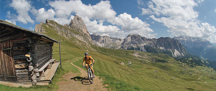
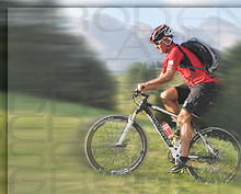
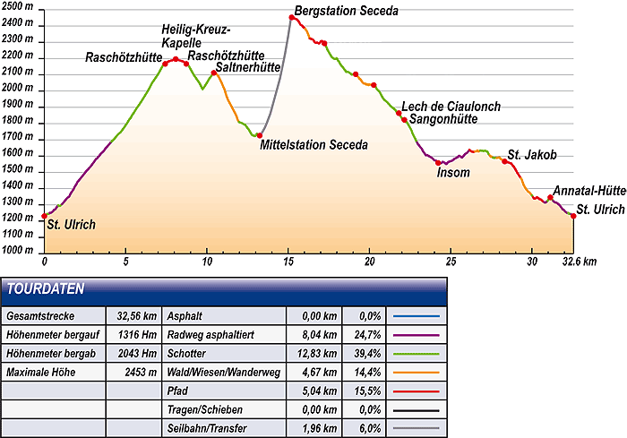
This tour through the Puez-Geisler nature park is one of the most impressive mountain bike ventures in the Gardena valley. The panoramic path from the Raschötz mountain cabin as far as the Holy Cross Chapel alone would be worth the almost 1,000m in altitude difference from St. Ulrich. But there is still better to come. In the second half of the tour you pass through inspired trails straight to the foot of the steeply towering Geisler mountain range. There the distinctive Pieralongia rock formation is waiting with scenery for the perfect souvenir photo. A long descent leads back into the Gardena valley, where the fantastic mountain path from Insom via St. Jakob's church as far as the Anna valley completes an unforgettable mountain bike adventure.
There is not a lot of time for warming-up for shortly after the start of the tour at the tourism association in St. Ulrich you will have to start changing down as you will be going uphill only. First of all to the valley station of the Seceda cable car, after this initially on a tarmac road and later on the woodland track with switchbacks that time and again cross the line of the new Raschötz funicular railway. At the last switchback go straight on until you reach the mountain path further up at 150m altitude difference that leads from the mountain station of the Raschötz funicular railway to the Holy Cross Chapel. This finishes the ascent and so you can happily enjoy the fantastic panorama this mountain path offers. Directly opposite the green meadows of the Seiser Alm spread out. Behind them the pointed peaks of the Langkofel tower steeply up into the sky. Further on on the left the well-known Sella mountain range rises up. When the weather is fine you can make out the Marmolada precisely between the white glacier surfaces in the structure of the peak.
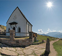
The mountain path only rises gently as far as the idyllically located Holy Cross Chapel to the crossing into the neighbouring Villnöß valley. Here you turn round to enjoy again to the full the view on the trip back to the Raschötz mountain cabin and roll along back on the route known from your ascent to the woodland path that you follow uphill for the last few metres as far as the mountain station of the Raschötz funicular railway. A little later you arrive at the Saltner mountain cabin from where you will have a similarly beautiful view to the one you had earlier on the mountain path.
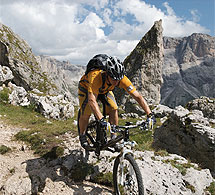
The steep descent on the ski piste in the direction of the intermediate station Seceda begins immediately behind the mountain cabin. The cable car takes the bikers and bikes in a short time to the highest point of the tour at 2,450m above sea level. Now the Geisler mountain range seems to be close enough to touch and together with the Mont de Stevia, the Sella mountain range, the Langkofel and Plattkofel forms a real amphitheatre of rocks.
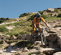
There now comes the best part of the tour for riding technique experts.
You descend a further 800m of altitude difference past the Sangon hut until almost to the valley station of Col Raiser. You continue via the remote hamlet of Insom in the direction of Sankt Jakob, still somewhat above and away from the hustle and bustle of the valley. The path becomes ever narrower and provides a lot of fun before reaching the oldest church of the Gardena valley.
The small church of Sankt Jakob with its distinctive tower, contemplative cemetery and frescoes well worth seeing, has a box seat view of the valley. Bikers enjoy this on the spacious sunbathing lawn near to the church with its sweeping view as far as the Plattkofel, Langkofel and Sella mountain range.
There follows three kilometres of sheer riding fun on the narrow woodland path leading to the Anna valley. Still in the forest the narrow trails alternate with wide woodland paths, switchbacks and small wooden bridges that make you wish that it could go on for ever.
Unfortunately, the trails end at the Pauli mountain cabin. It is only a few metres still to the well-tended Annatal mountain cabin, the last stop for refreshments on this tour. Tables in the shade or sun loungers in the sun invite you to take a good, long rest. Or you can cool off your hot feet in the stream behind the sunbathing lawn. After refreshments you can roll along, almost only downhill, past the valley station of the Seceda cable car back to the centre of St. Ulrich.
| |
 |
| |
Variations
1. Ascent with the Raschötz funicular railway: this tour is decidedly shorter and easier if you use the recently built (2010) Raschötz funicular railway. To this end do not go straight on at waymarker 4 at the valley station of Seceda, turn left instead. Follow the signposts to Raschötz and take the train/cable car. Below the mountain station join the tour described here again at waymarker 24 and continue directly on to the Saltner mountain cabin, omitting the mountain path to the Holy Cross church. You save about 1,000m in altitude difference and a bit less than 10km.
2. Leaving out Raschötz mountain cabin and the Holy Cross church: The tour will be somewhat shorter if you take a sharp right turn at waymarker 17 and go in the direction of the mountain station Raschötz (-185m altitude difference, -3.3km).
3. Extension via La Poza and Langental: Whoever would like to extend the tour a bit should not take a sharp right turn into the underground passage at the junction shortly before the valley station of Col Raiser (waymarker 57), but bear left further downhill. Via La Poza in the direction of Wolkenstein and further on into the Langental, you can ride along the cross-country ski run as far as you want (at a maximum to the start of the mountain pasture Pra da Ri). Back again on the cross-country run bear left at the car park and via the valley station of Dantercepies to Wolkenstein. From there still on the left side of rio Gardena back to St. Ulrich (corresponds exactly to the first part of the Gardena valley tour).
4. Leaving out the Anna valley mountain cabin: Whoever at the end of the tour does not want to stop for more refreshments should not turn sharp right into the Annatal at the junction (waymarker 83), but carry straight on in the direction of valley station Seceda (-33m altitude difference, -0.7km). |
| |
|
| |
TOUR INFORMATION
Tour information |
|
% of distance |
Total distance |
32,56 km |
100 % |
Height variation uphill |
1316 Hm |
|
Height variation downhill |
2043 Hm |
|
Maximum altitude |
2453 m |
|
Tarmac |
0,00 km |
| 0,0 % |
 |
|
Tarmac cycle path |
8,04km |
24,7 %
|
 |
|
Gravel |
12,83 km |
| 39,4 % |
 |
|
Hiking trail |
4,67 km |
14,4 %
|
 |
|
Single track |
5,04 km |
15,5 %
|
 |
|
Carrying / pushing |
0,00 km |
0,0 %
|
 |
|
Cable car / transfer |
1,96 km |
6,0 %
|
 |
|
|
| |
|
|
Riding times |
Riding time without pauses |
Riding time at 10 km/h |
3 hrs 15 min |
Riding time at 12 km/h |
2 hrs 43 min |
Riding time at 14 km/h |
2 hrs 20 min |
Riding time at 16 km/h |
2 hrs 02 min |
Riding time at 18 km/h |
1 hr 49 min |
Riding time at 20 km/h |
1 hr 38 min |
| |
|
| |
|
| |
|
| |
|
| |
|
|
|
| |
|
Physical condition |
|
|
Overall condition |
3,6 |
|
Total height variation |
4,0 |
|
Total distance |
3,0 |
|
Maximum altitude |
4,0 |
|
|
|
Riding technique |
|
|
Overall riding technique |
4,2 |
|
Surface |
3,8 |
|
Average climb gradient Ø |
5,0 |
|
Average descent gradient Ø |
4,0 |
|
|
|
| |
|
Tour evaluation |
|
|
Overall difficulty |
4,0 |
|
Climb difficulty |
3,9 |
|
Descent difficulty |
4,3 |
|
|
|
Emotional experience |
|
|
Panorama |
5,0 |
|
Riding fun |
4,0 |
|
| |
|
|
|
|
| |
|
GETTING THERE AND STARTING POINT
Getting there
Take Brenner motorway A22, coming from the north via Innsbruck-Brenner, or from the south via Verona-Bozen.
The best motorway exit is Klausen/Gröden. From there in about 20 minutes you can reach St Ulrich and a few kilometres further on St. Christina and Wolkenstein on a clearly signposted mountain road.
Starting point
This tour begins at the tourism association in St. Ulrich.
Parking is available at the valley station of the Seceda cable car. |
| |
ROADBOOK
No |
km |
Next |
Hm |
Sym |
Location |
Direction |
Route |
Time 22 km/h |
Time 10 km/h |
1 |
0,00 |
0,08 |
1231 |
|
Tourist information office in St. Ulrich/Ortisei |
Right to St. Jakob/San Giacomo |
|
00:00 |
00:00 |
2 |
0,08 |
0,07 |
1235 |
|
Church in Ortisei |
Straight ahead Sacun |
|
00:00 |
00:00 |
3 |
0,15 |
0,18 |
1243 |
|
Junction (stone) |
Bear left Annatal 9 |
|
00:00 |
00:00 |
4 |
0,33 |
0,52 |
1251 |
|
Bottom of Seceda lift |
Straight ahead uphill Annatal |
|
00:00 |
00:01 |
5 |
0,85 |
0,05 |
1298 |
|
Playground |
left |
|
00:02 |
00:05 |
6 |
0,90 |
0,19 |
1294 |
|
Bridge over brook |
Straight ahead |
|
00:02 |
00:05 |
7 |
1,10 |
0,08 |
1305 |
|
Junction |
Straight ahead uphill |
|
00:02 |
00:06 |
8 |
1,18 |
0,11 |
1314 |
|
Kehre, Fountain |
Straight ahead Annatal |
|
00:03 |
00:07 |
9 |
1,28 |
0,74 |
1328 |
|
Junction Str. Sobosch |
Sharp right to Raschötz/ Rasciesa 7 |
|
00:03 |
00:07 |
10 |
2,02 |
0,31 |
1438 |
|
Junction Streda Costes |
Straight ahead uphill |
|
00:05 |
00:12 |
11 |
2,33 |
0,07 |
1475 |
|
Junction |
Sharp left uphill Raschötz 9 |
|
00:06 |
00:13 |
12 |
2,40 |
1,06 |
1484 |
|
Fountain |
Straight ahead uphill |
|
00:06 |
00:14 |
13 |
3,46 |
0,68 |
1613 |
|
Junction to Furnes |
Straight ahead Raschötz |
|
00:09 |
00:20 |
14 |
4,13 |
0,37 |
1689 |
|
Under cable car |
Straight ahead |
|
00:11 |
00:24 |
15 |
4,50 |
0,19 |
1730 |
|
Junction to Troi Paian 8 |
Sharp right Raschötz |
|
00:12 |
00:27 |
16 |
4,69 |
1,75 |
1746 |
|
Junction to Furnes 8 |
Straight ahead uphill |
|
00:12 |
00:28 |
17 |
6,44 |
0,94 |
2012 |
|
Junction at hairpin bend |
Bear left UTIA Resciesa
(CAI-Hütte) |
|
00:17 |
00:38 |
18 |
7,37 |
0,06 |
2164 |
|
Intersection kurz vor Hütte |
Bear left zur Hütte,
Heilig-Kreuz-Chapel |
|
00:20 |
00:44 |
19 |
7,43 |
0,65 |
2167 |
|
Raschötzhütte |
Bear left Heilig-Kreuz-Chapel |
|
00:20 |
00:44 |
20 |
8,08 |
0,65 |
2197 |
|
Heilig-Kreuz-Chapel |
Turn back |
|
00:22 |
00:48 |
21 |
8,73 |
0,06 |
2167 |
|
Raschötzhütte |
Bear right Bergstation, Brogles |
|
00:23 |
00:52 |
22 |
8,80 |
0,94 |
2164 |
|
Junction kurz nach Raschötzhütte |
Bear right downhill
St. Ulrich |
|
00:23 |
00:52 |
23 |
9,73 |
0,51 |
2012 |
|
Intersection in bend |
Bear left uphill Chairlift, Restaurant |
|
00:26 |
00:58 |
24 |
10,24 |
0,14 |
2088 |
|
Junction below top of lift |
Straight ahead uphill |
|
00:27 |
01:01 |
25 |
10,38 |
0,05 |
2109 |
|
Junction towards top station |
Straight ahead uphill |
|
00:28 |
01:02 |
26 |
10,43 |
0,07 |
2112 |
|
Junction hiking trail bei Saltnerhütte |
Straight ahead uphill Brogles Hütte |
|
00:28 |
01:02 |
27 |
10,50 |
0,23 |
2118 |
|
Junction hinter Saltnerhütte |
Bear right Furnes,
St. Ulrich (über den Zaun zu großem Fountain, dann Skipiste folgen) |
|
00:28 |
01:02 |
28 |
10,73 |
0,34 |
2088 |
|
Junction to Col Ciarnacei, Furnes, St. Ulrich 9 |
Right Furnes (Skipiste folgen) |
|
00:29 |
01:04 |
29 |
11,07 |
0,09 |
2014 |
|
Junction hiking trail 9 |
Straight ahead Furnes |
|
00:30 |
01:06 |
30 |
11,16 |
0,14 |
1986 |
|
Junction to Col Ciarnacei, Furnes, St. Ulrich 9 |
Straight ahead Furnes |
|
00:30 |
01:06 |
31 |
11,30 |
0,68 |
1947 |
|
Crossroad |
Straight ahead Furnes |
|
00:30 |
01:07 |
32 |
11,98 |
0,39 |
1809 |
|
Crossroad Forststraße |
Bear right St. Ulrich |
|
00:32 |
01:11 |
33 |
12,36 |
0,27 |
1792 |
|
Crossroad nach St. Ulrich und Raschötz (Schild Naturpark) |
Sharp left Furnes 8 |
|
00:33 |
01:14 |
34 |
12,63 |
0,14 |
1754 |
|
Jagdhütte |
Straight ahead |
|
00:34 |
01:15 |
35 |
12,77 |
0,13 |
1730 |
|
Junction zur Hütte |
Sharp left Seilbahn Seceda, Furnes 8 (über lange Bridge over brook) |
|
00:34 |
01:16 |
36 |
12,91 |
0,35 |
1726 |
|
Crossroads gravel road |
Straight ahead Furnes (kurze Schiebepassage) |
|
00:35 |
01:17 |
37 |
13,25 |
1,97 |
1726 |
|
Middle station Seceda |
Take gondola lift |
|
00:36 |
01:19 |
38 |
15,22 |
0,32 |
2453 |
|
Bergastation Seceda |
Bear left Sangon Hut |
|
00:41 |
01:31 |
51 |
21,81 |
0,29 |
1864 |
|
Lech de Ciaulonch
(kleiner See) |
Right Sangon Hütte,
St. Christina 1 |
|
00:59 |
02:10 |
52 |
22,10 |
0,05 |
1825 |
|
Junction to Wolkenstein, Bridge over brook |
Bear right St. Christina 1 |
|
01:00 |
02:12 |
53 |
22,15 |
0,16 |
1823 |
|
Junction zur Sangonhütte (80m) |
Bear left downhill |
|
01:00 |
02:12 |
54 |
22,31 |
0,38 |
1808 |
|
Junction zur Aschgleralm |
Bear left downhill |
|
01:00 |
02:13 |
55 |
22,68 |
0,26 |
1734 |
|
Junction zur Baiten Hütte 1 |
Bear left downhill |
|
01:01 |
02:16 |
56 |
22,94 |
0,53 |
1684 |
|
Junction, Bach mit Staustufen |
Bear right |
|
01:02 |
02:17 |
57 |
23,47 |
0,08 |
1605 |
|
|
Sharp right Str. Insom (durch Subway) |
|
01:04 |
02:20 |
58 |
23,55 |
0,02 |
1605 |
|
Crossroad
(zur Pramulin-Hütte) |
Straight ahead over bridge |
|
01:04 |
02:21 |
59 |
23,57 |
0,66 |
1606 |
|
Intersection nach Bridge |
left downhill |
|
01:04 |
02:21 |
60 |
24,23 |
0,15 |
1558 |
|
Insom |
Straight ahead St. Christina |
|
01:06 |
02:25 |
61 |
24,39 |
0,21 |
1556 |
|
Junction towards the centre of S. Cristina |
Straight ahead St. Christina Kirche |
|
01:06 |
02:26 |
62 |
24,60 |
0,13 |
1561 |
|
Hydrant |
left downhill |
|
01:07 |
02:27 |
63 |
24,73 |
0,06 |
1551 |
|
Intersection |
Straight ahead Prauletta |
|
01:07 |
02:28 |
64 |
24,79 |
0,60 |
1558 |
|
Junction Str. Col da Messa |
Straight ahead uphill St. Jakob |
|
01:7 |
02:28 |
65 |
25,39 |
0,31 |
1591 |
|
Junction to Seceda |
Straight ahead St. Jakob |
|
01:09 |
02:32 |
66 |
25,70 |
0,46 |
1591 |
|
Junction to Uleta |
Bear right St. Jakob |
|
01:10 |
02:34 |
67 |
26,16 |
0,34 |
1639 |
|
Chapel |
left St. Jakob Kirche |
|
01:11 |
02:36 |
68 |
26,50 |
0,14 |
1629 |
|
Junction 20m after wayside cross |
Straight ahead St. Jakob |
|
01:12 |
02:39 |
69 |
26,65 |
0,17 |
1635 |
|
Crossroad (nach Seceda) |
Straight ahead St. Jakob |
|
01:12 |
02:39 |
70 |
26,82 |
0,44 |
1635 |
|
Junction gravel road |
Bear left towards St. Jakob/San Giacomo |
|
01:13 |
02:40 |
71 |
27,26 |
0,14 |
1627 |
|
Junction to Siurasas |
Straight ahead St. Jakob |
|
01:14 |
02:43 |
72 |
27,40 |
0,21 |
1604 |
|
Junction towards St. Ulrich/ Ortisei |
Straight ahead St. Jakob Kirche |
|
01:14 |
02:44 |
73 |
27,61 |
0,22 |
1590 |
|
Junction gravel road |
Bear right St. Jakob |
|
01:15 |
02:45 |
74 |
27,84 |
0,47 |
1589 |
|
End of gravel road |
Straight ahead |
|
01:15 |
02:47 |
75 |
28,30 |
0,02 |
1565 |
|
Fountain vor Kirche |
Straight ahead |
|
01:17 |
03:49 |
76 |
28,33 |
0,03 |
1567 |
|
Kiche St. Jakob |
Straight ahead |
|
01:17 |
02:49 |
77 |
28,35 |
0,30 |
1564 |
|
Junction to Sacun |
Straight ahead Col de Flam |
|
01:17 |
02:50 |
78 |
28,65 |
0,69 |
1557 |
|
Crossroad |
Straight ahead St. Ulrich |
|
01:18 |
02:51 |
79 |
29,34 |
0,66 |
1463 |
|
Junction with track |
Sharp right downhill |
|
01:20 |
02:56 |
80 |
30,00 |
0,08 |
1359 |
|
Junction |
Sharp right St. Ulrich/Ortisei 6 |
|
01:21 |
02:59 |
81 |
30,07 |
0,68 |
1347 |
|
Fountain |
Straight ahead zwischen Benchesn hindurch Annatal |
|
01:22 |
03:00 |
82 |
30,76 |
0,01 |
1317 |
|
Pauli-Hütte |
left downhill |
|
01:23 |
03:04 |
83 |
30,77 |
0,19 |
1315 |
|
Tree with wayside cross |
Sharp right |
|
01:23 |
03:04 |
84 |
30,96 |
0,05 |
1324 |
|
Bridge |
Straight ahead |
|
01:24 |
03:05 |
85 |
31,01 |
0,12 |
1332 |
|
Junction |
Bear right towards guesthouse |
|
01:24 |
03:06 |
86 |
31,13 |
0,12 |
1346 |
|
Annatal-Hütte |
Turn back |
|
01:24 |
03:06 |
87 |
31,26 |
0,05 |
1332 |
|
Junction |
Bear left towards bridge |
|
01:25 |
03:07 |
88 |
31,31 |
0,19 |
1324 |
|
Bridge |
Straight ahead |
|
01:25 |
04:07 |
89 |
31,50 |
0,21 |
1315 |
|
Tree with wayside cross
(zur Pauli-Hütte) |
Bear right downhill |
|
01:25 |
03:08 |
90 |
31,71 |
0,52 |
1298 |
|
Playground |
Straight ahead downhill |
|
01:26 |
3:10 |
91 |
32,23 |
0,18 |
1251 |
|
Bottom of Seceda lift |
Straight ahead downhill |
|
01:27 |
3:13 |
92 |
32,41 |
0,07 |
1243 |
|
Junction tarmac road (Stein) |
Bear right downhill towards church |
|
01:28 |
03:14 |
93 |
32,48 |
0,08 |
1236 |
|
Church in Ortisei |
Straight ahead zum Tourismusverein |
|
01:28 |
03:14 |
94 |
32,56 |
0,00 |
1231 |
|
Tourist information office in St. Ulrich/Ortisei |
End of tour |
|
01:28 |
03:15 |
EXPLANATION OF EVALUATION FACTORS, SURFACE AND SLOPE
Explanation of evaluation factors
• Overall difficulty based on climb difficulty (60%) and descent difficulty (40%)
• Climb difficulty based on total distance uphill (30%), overall height variation uphill (30%), surface uphill (10%), average slope uphill (25%), highest altitude reached (5%).
• Descent difficulty consists of total distance downhill (10%), overall height variation downhill (10%), surface downhill (50%), average slope downhill (30%).
• Physical condition based on total distance (40%), with overall height variation (50%) and highest altitude reached (10%).
• Riding technique based on surface (50%), with average slope uphill (30%) and average slope downhill (20%).
• Writer’s subjective evaluation of panorama and riding fun.
Explanation of surface and slope |
|
|
|
A = Tarmac road |
|
steep uphill |
from + 15% |
R = Tarmac cycle path |
|
uphill |
up to + 14% |
S = Gravel |
|
level |
ca. +/- 4% |
W = Hiking trail |
|
downhill |
up to - 19% |
P = Path, Single Trail |
|
steep downhill |
from - 20% |
T = Carrying / pushing |
|
|
|
X = Cable car / transfer |
|
|
|
Route: the percentages indicate the average climb (+) or the average descent (-) to the next waymarker. |
DOWNLOADS
| |
 |
 |
 |
CHARACTERISTICS |
ALTITUDE PROFILE |
MAP |
|
| |
|


