|
CHARACTERISTICS AND VARIATIONS
Characteristics
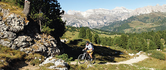
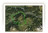
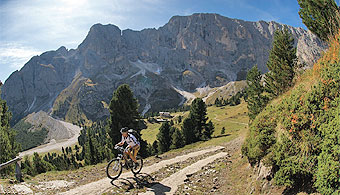
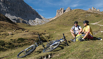
This tour, featuring some of the region’s most spectacular landscapes, leads us up the largely unspoilt Duron Valley that extends on the southern side of the Plattkofel/Sassopiatto and forms the border with the adjacent Rosengarten/Catinaccio Group, with its 3000-metre summits. Bikers must overcome two tough climbs to discover this gem, but then come two highly enjoyable descents offering wonderful views of the surrounding Dolomites. Exactly halfway around, in the heart of the Val Duron, you can stop for refreshments and enjoy both the landscape and the peaceful atmosphere.
From the Tourist Information Office in Wolkenstein/Selva you warm up along the route of the old railway line, climbing gently. You then follow the road up to Plan de Gralba for approximately 2.5 km: although it is busy with traffic in the high season (there is no alternative route), the 200m ascent does not take long. From Plan de Gralba the climb gets steeper up to the Sellajoch/Passo Sella, first on a gravel road, then along a fantastic trail with tight curves leading up to the lower reaches of the “City of Stone”: while this poses no difficulties for fit and experienced bikers, pushing your bike for a few metres will also allow you to admire the magnificent views of the Langkofel/Sassolungo towering above you.
Shortly after the car park for the cable car up to the Langkofelscharte/Forcella del Sassolungo gorge, the long descent towards Canazei and Campitello starts at the Valentini Hut (the first opportunity for refreshments). The upper part is especially fine, with breathtaking panoramas and some tricky sections to overcome under the Lupo Bianco.
In Campitello, at the beginning of the Val Duron, the route changes abruptly from downhill to uphill, with a forest trail featuring a gradient of up to 24%! This practically unrideable stretch only lasts some 30m before becoming a more moderate 14/15% to the Duron Hut. The valley suddenly opens up to reveal a magnificent view of the rock walls that line it on both sides.
After a short downhill stretch you reach the very traditional Lino Brach Hut at the side of the path, where you can stop and regain your strength; among the gastronomic treats on offer we recommend the polenta with sausage and gorgonzola.
The tour now continues further up the Duron Valley to the Mahlknechtjoch/Duron pass, with magnificent views of the Rosengartengruppe/Catinaccio Group to the south and the Plattkofel/Sassopiatto to the north. The gradient approaches 20% in parts, but now the peaks of the Rosszähne/Denti di Terra Rossa, and thus the route to the Seiser Alm/Alpe di Siusi, are visible. Be sure to stop for a breather during the upper stages of the climb and look back over the surrounding landscape, where to the east you can even see the Marmolada!
The next highlight of the tour, heading towards the Plattkofel/Sassopiatto, is the panoramic trail from the Dialer Church in the direction of Zallinger. Your bike is put to the test along a narrow hiking trail that will make you forget the hard climb up the Val Duron; but the fun has to end after 2 km as the next section, featuring obstacles and steps, is reserved for hikers.
Now comes a descent of 160m, followed by a climb on a gravel road in the direction of the Zallinger Hut, a real gem: the view from its terrace to the south-east reveals the “flat” face of the Plattkofel/Sassopiatto, lit by the afternoon sun, while to the south-west is the panorama in the direction of the Plattkofel/Sassopiatto Hut, Palatsch/Palacia, the Mahlknecht Hut and the Rosszähne/Denti di Terra Rossa.
The next 12 kilometres are largely downhill in full view of the Plattkofel/Sassopiatto and Langkofel/Sassolungo until, tired but happy, you return to your starting point in Wolkenstein/Selva.
| |
 |
| |
Variations
1. Pain and pleasure: extension to the Tierser Alpl Hut. If, having reached the top of the Val Duron, you still have the appetite for new adventures, you can take the very steep section up towards the Tierser Alpl Hut. At waymarker 64, just before the Mahlknechtjoch/Passo Duron pass, go left onto the trail to the hut, which later becomes a cart track. A climb of 260m brings you to an oasis of tranquillity under the Rosszähne/Denti di Terra Rossa. Why not spend the night at the hut? Enjoy the warm welcome amid the splendid surroundings, then return the following day to the cart track and down to waymarker 65, just before the Dialer Church where you rejoin the tour described above.
2. In the opposite direction (partly by cable car): covering the route in the reverse direction allows you to appreciate the splendours of the Val Duron downhill from the Mahlknechtjoch/Passo Duron. At waymarker 47 you can then take the cable car up to Col Rodella, thus avoiding a climb of 1,000m. From the top you descend to the Valentini Hut and at waymarker 25 bear left to rejoin the tour described above (to waymarker 1).
3. Ascent on the road over the pass: it is possible to do the climb from Plan de Gralba to the car park of the Langkofelscharte/Forcella del Sassolungo cable car entirely up the road over the Sellajoch/Passo Sella, but only advisable when traffic is light. At waymarker 10 in Plan de Gralba go straight on, climbing up the main road. Just before the Sellajoch/Passo Sella, on the right is the car park for the cable car, where you rejoin the tour described above at waymarker 23. |
| |
|
| |
TOUR INFORMATION
Tour information |
|
% of distance |
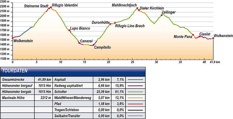
Total distance |
41,89 km |
100 % |
Height variation uphill |
1815 Hm |
|
Height variation downhill |
1815 Hm |
|
Maximum altitude |
2212 m |
|
Tarmac |
2,96 km |
| 7,1 % |
 |
|
Tarmac cycle path |
6,66 km |
15,9 %
|
 |
|
Gravel |
25,59 km |
| 61,1 % |
 |
|
Hiking trail |
5,07 km |
12,1 %
|
 |
|
Single track |
1,58 km |
3,8 %
|
 |
|
Carrying / pushing |
0,00 km |
0,0 %
|
 |
|
Cable car / transfer |
0,00 km |
0,0 %
|
 |
|
|
| |
|
|
Riding times |
Riding time without pauses |
Riding time at 10 km/h |
4 hrs 11 min |
Riding time at 12 km/h |
3 hrs 29 min |
Riding time at 14 km/h |
3 hrs 00 min |
Riding time at 16 km/h |
2 hrs 37 min |
Riding time at 18 km/h |
2 hrs 20 min |
Riding time at 20 km/h |
2 hrs 06 min |
| |
|
| |
|
| |
|
| |
|
| |
|
|
|
| |
|
Physical condition |
|
|
Overall condition |
4,0 |
|
Total height variation |
4,0 |
|
Total distance |
4,0 |
|
Maximum altitude |
4,0 |
|
|
|
Riding technique |
|
|
Overall riding technique |
3,6 |
|
Surface |
3,2 |
|
Average climb gradient Ø |
4,0 |
|
Average descent gradient Ø |
4,0 |
|
|
|
| |
|
Tour evaluation |
|
|
Overall difficulty |
3,8 |
|
Climb difficulty |
3,9 |
|
Descent difficulty |
3,5 |
|
|
|
Emotional experience |
|
|
Panorama |
5,0 |
|
Riding fun |
4,0 |
|
| |
|
|
|
|
| |
|
GETTING THERE AND STARTING POINT
Getting there
Take Brenner motorway A22, coming from the north via Innsbruck-Brenner, or from the south via Verona-Bozen.
The best motorway exit is Klausen/Gröden. From there in about 20 minutes you can reach St Ulrich and a few kilometres further on St. Christina and Wolkenstein on a clearly signposted mountain road.
Starting point
The tourism association is located on the left about 500m after you enter the village of Wolkenstein.
Parking is available at the the beginning of the village centre of Wolkenstein. Turn left before Nives Platz and then immediately left again into the Nives car park.
The tour begins at the tourism association Wolkenstein.
|
| |
ROADBOOK
No |
km |
Next |
Hm |
Sym |
Location |
Direction |
Route |
Time 22 km/h |
Time 10 km/h |
1 |
0,00 |
0,17 |
1557 |
|
Tourist information office in Wolkenstein/Selva |
Straight on uphill |
|
00:00 |
00:00 |
2 |
0,17 |
0,09 |
1566 |
|
Bottom of Ciampinoi lift |
Straight on |
|
00:00 |
00:01 |
3 |
0,25 |
0,04 |
1566 |
|
Hotel Krone |
Bear right onto main road |
|
00:00 |
00:01 |
4 |
0,29 |
0,09 |
1567 |
|
Junction with Str. Dantercepies |
Sharp left Langental/Vallunga |
|
00:00 |
00:01 |
5 |
1,38 |
0,28 |
1577 |
|
Hotel Sun Valley |
Sharp right onto course of old railway |
|
00:01 |
00:02 |
6 |
0,65 |
0,77 |
1581 |
|
Hotel La Tambra |
Bear left on course of old railway |
|
00:01 |
00:03 |
7 |
1,43 |
0,14 |
1593 |
|
Casa Alpina |
Bear left to Grödner Joch/Passo Gardena |
|
00:03 |
00:08 |
8 |
1,57 |
0,91 |
1606 |
|
Hotel Plan Alpino |
Straight on following main road |
|
00:04 |
00:09 |
9 |
2,48 |
1,34 |
1675 |
|
Junction with hiking trail 654 in bend |
Sharp right following main road |
|
00:06 |
00:14 |
10 |
3,82 |
0,07 |
1780 |
|
Junction |
Bear right to Piz Sella lift |
|
00:10 |
00:22 |
11 |
3,89 |
0,15 |
1781 |
|
Junction to Plan |
Bear left to bottom of Piz Sella lift |
|
00:10 |
00:23 |
12 |
4,04 |
0,14 |
1783 |
|
Bottom of the Piz Sella lift |
Right |
|
00:11 |
00:24 |
13 |
4,18 |
0,27 |
1787 |
|
Bridge over Rio Gardena stream |
After bridge bear left over car park |
|
00:11 |
00:25 |
14 |
4,45 |
0,69 |
1805 |
|
Junction to Jeuf de Frea (near bottom of drag lift) |
Straight on |
|
00:12 |
00:26 |
15 |
5,14 |
0,60 |
1910 |
|
Wayside cross |
Follow main path |
|
00:14 |
00:30 |
16 |
5,74 |
0,63 |
1975 |
|
Junction |
Bear left |
|
00:15 |
00:34 |
17 |
6,38 |
0,53 |
2047 |
|
Crossroads |
Straight on |
|
00:17 |
00:38 |
18 |
6,90 |
0,05 |
2108 |
|
Crossroads |
Straight on |
|
00:18 |
00:41 |
19 |
6,96 |
0,03 |
2111 |
|
Junction by hut |
Straight on between hut and barn |
|
00:18 |
00:41 |
20 |
6,99 |
0,49 |
2113 |
|
Meadow fence after hut |
Straight on |
|
00:19 |
00:41 |
21 |
7,48 |
0,10 |
2171 |
|
Crossroads by hut |
Straight on Naturonda |
|
00:20 |
00:44 |
22 |
7,58 |
0,06 |
2180 |
|
Junction |
Left to car park |
|
00:20 |
00:45 |
23 |
7,64 |
0,11 |
2181 |
|
Car park at bottom of Langkofelscharte gorge lift |
Straight on uphill |
|
00:20 |
00:45 |
24 |
7,75 |
0,16 |
2190 |
|
Junction near chapel |
Straight on |
|
00:21 |
00:46 |
25 |
7,92 |
0,10 |
2212 |
|
Crossroads (to Salei Hut) |
Straight on Valentini Hut |
|
00:21 |
00:47 |
26 |
8,02 |
0,35 |
2203 |
|
Valentini Hut |
Left downhill |
|
00:21 |
00:48 |
27 |
8,37 |
1,46 |
2154 |
|
End of gravel road |
Straight on |
|
00:22 |
00:50 |
28 |
9,83 |
0,75 |
2009 |
|
Val 2000 |
Right to Lupo Bianco |
|
00:26 |
00:58 |
29 |
10,58 |
0,94 |
1893 |
|
Wayside cross |
Sharp left downhill |
|
00:28 |
01:03 |
30 |
11,52 |
0,15 |
1738 |
|
Bridge over stream |
Straight on to Canazei |
|
00:31 |
01:09 |
31 |
11,67 |
0,05 |
1724 |
|
Junction |
Straight on |
|
00:31 |
01:10 |
32 |
11,71 |
0,12 |
1724 |
|
Plan de Frataces 1725 |
Bear right |
|
00:31 |
01:10 |
33 |
11,84 |
0,14 |
1720 |
|
Lupo Bianco (lake) |
Bear left Canazei 655 |
|
00:32 |
01:11 |
34 |
11,98 |
0,20 |
1713 |
|
Junction |
Straight on |
|
00:32 |
01:11 |
35 |
12,18 |
0,18 |
1662 |
|
Bend 8 |
Stay on trail |
|
00:33 |
01:13 |
36 |
12,36 |
1,33 |
1654 |
|
Intersection with gravel road |
Sharp right downhill |
|
00:33 |
01:14 |
37 |
13,69 |
0,24 |
1494 |
|
Bridge |
Bear left over bridge |
|
00:37 |
01:22 |
38 |
13,93 |
0,11 |
1452 |
|
Church of Canazei |
Sharp right |
|
00:37 |
01:23 |
39 |
14,03 |
0,15 |
1448 |
|
Bridge |
Left after bridge into Strada Roma |
|
00:38 |
01:24 |
40 |
14,18 |
0,29 |
1439 |
|
Crossing with main road |
Straight on along Strada Roma |
|
00:38 |
01:25 |
41 |
14,47 |
0,18 |
1425 |
|
Hotel Genzianella |
Sharp left at sports ground |
|
00:39 |
01:26 |
42 |
14,65 |
0,17 |
1426 |
|
Intersection Strèda de Cerenà |
Right |
|
00:39 |
01:27 |
43 |
14,81 |
0,85 |
1420 |
|
Cardo Residence |
Bear right across meadow |
|
00:40 |
01:28 |
44 |
15,66 |
0,54 |
1423 |
|
Beginning of gravel road |
Straight on |
|
00:42 |
01:33 |
45 |
16,20 |
0,20 |
1402 |
|
Car park for tennis courts |
Straight on |
|
00:44 |
01:37 |
46 |
16,40 |
0,06 |
1405 |
|
Car park at bottom of Col Rodella lift |
Right towards cable car |
|
00:44 |
01:38 |
47 |
16,46 |
0,10 |
1400 |
|
Bottom of Col Rodella lift in Campitello |
Straight on |
|
00:44 |
01:38 |
48 |
16,56 |
0,34 |
1400 |
|
Car park at bottom of Col Rodella lift |
Right over bridge over stream |
|
00:45 |
01:39 |
49 |
16,89 |
0,19 |
1414 |
|
Albergo Ladino in Campitello |
Left/right crossing main road |
|
00:46 |
01:41 |
50 |
17,08 |
0,53 |
1430 |
|
Crossing just before end of village |
Straight on uphill Streda de salin |
|
00:46 |
01:42 |
51 |
17,61 |
0,61 |
1500 |
|
Bridge over stream, car park |
Straight on steep uphill |
|
00:48 |
01:45 |
52 |
18,22 |
0,08 |
1557 |
|
Junction |
Straight on to Antermoia Hut |
|
00:49 |
01:49 |
53 |
18,30 |
0,83 |
1568 |
|
Bridge over stream |
Straight on |
|
00:49 |
01:49 |
54 |
19,13 |
1,05 |
1679 |
|
Junction towards Sandro Pertini Hut |
Straight on to Antermoia Hut |
|
00:52 |
01:54 |
55 |
20,18 |
0,03 |
1827 |
|
Junction to Sentiero per Campitello |
Straight on |
|
00:55 |
02:01 |
56 |
20,21 |
0,18 |
1828 |
|
Junction to Antermoia Hut |
Straight on to Plattkofel Hut |
|
00:55 |
02:01 |
57 |
20,39 |
0,06 |
1852 |
|
|
Straight on |
|
00:55 |
02:02 |
58 |
20,45 |
0,03 |
1861 |
|
Junction to Plattkofel Hut |
Bear left to Passo Duron |
|
00:55 |
02:02 |
59 |
20,48 |
0,90 |
1865 |
|
Junction above Duron Hut |
Left following main hiking trail |
|
00:55 |
02:02 |
60 |
21,38 |
0,86 |
1875 |
|
Lino Brach Hut |
Straight on |
|
00:58 |
02:08 |
61 |
22,24 |
1,91 |
1897 |
|
Junction to Antermoia Hut |
Straight on to Passo Duron |
|
01:00 |
02:13 |
62 |
24,15 |
0,72 |
1967 |
|
Junction to Antermoia Hut |
Straight on to Passo Duron |
|
01:05 |
02:24 |
63 |
24,87 |
1,16 |
2047 |
|
Hut |
Straight on uphill |
|
01:07 |
02:29 |
64 |
26,03 |
0,35 |
2185 |
|
Mahlknechtjoch, Passo Duron |
Straight on uphill |
|
01:10 |
02:36 |
65 |
26,38 |
0,12 |
2143 |
|
Dialer Church/Chapel of St. Anthony |
Right |
|
01:11 |
02:38 |
66 |
26,50 |
0,25 |
2130 |
|
Below Dialer Church/Chapel of St. Anthony |
Sharp right Zallinger |
|
01:12 |
02:39 |
67 |
26,75 |
1,33 |
2119 |
|
Junction to Plattkofel Hut |
Straight on |
|
01:12 |
02:40 |
68 |
28,08 |
1,12 |
2021 |
|
Intersection |
Sharp left to Saltria |
|
01:16 |
02:48 |
69 |
29,20 |
0,30 |
1891 |
|
Intersection with bend |
Bear left downhill |
|
01:19 |
02:55 |
70 |
29,50 |
1,14 |
1859 |
|
Intersection with bend |
Bear right uphill |
|
01:20 |
02:57 |
71 |
30,64 |
0,47 |
1996 |
|
Bridge over stream |
Straight on Zallinger 7 |
|
01:23 |
03:03 |
72 |
31,11 |
0,18 |
2037 |
|
Zallinger Hut, Chapel,
Water source |
Bear left uphill |
|
01:24 |
03:06 |
73 |
31,29 |
0,14 |
2053 |
|
Junction towards Florian chairlift |
Bear right towards La Marmotta Hut |
|
01:25 |
03:07 |
74 |
31,44 |
3,11 |
2060 |
|
Junction to Plattkofel Hut |
Bear left
Monte Pana 7 |
|
01:25 |
03:08 |
75 |
34,55 |
0,35 |
1815 |
|
Intersection |
Bear right
Monte Pana |
|
01:34 |
03:27 |
76 |
34,89 |
0,46 |
1788 |
|
Junction to Langkofelscharte gorge |
Straight on downhill |
|
01:35 |
03:29 |
77 |
35,35 |
0,69 |
1782 |
|
Junction to Langkofelscharte gorge |
Straight on |
|
01:36 |
03:32 |
78 |
36,04 |
0,83 |
1760 |
|
Junction to Jender Valley |
Bear right
Monte Pana |
|
01:38 |
03:36 |
79 |
36,87 |
0,40 |
1702 |
|
Junction (towards Strena) |
Straight on downhill |
|
01:40 |
03:41 |
80 |
37,27 |
0,39 |
1662 |
|
Junction to ski jump |
Straight on downhill |
|
01:41 |
03:43 |
81 |
37,66 |
0,09 |
1624 |
|
Crossing with bottom of Monte Pana lift |
Straight on |
|
01:42 |
03:45 |
82 |
37,76 |
0,33 |
1625 |
|
Top of chair lift |
Straight on S. Cristina, Wolkenstein/Selva |
|
01:42 |
03:46 |
83 |
38,09 |
0,26 |
1561 |
|
Junction with hiking trail |
Bear right to Wolkenstein/Selva 30b |
|
01:43 |
03:48 |
84 |
38,35 |
0,08 |
1555 |
|
App. Prensanueva |
Straight on to Wolkenstein/Selva 30b |
|
01:44 |
03:50 |
85 |
38,44 |
0,50 |
1562 |
|
End of tarmac |
Straight on |
|
01:44 |
03:50 |
86 |
38,93 |
0,09 |
1581 |
|
Beginning of gravel path |
Straight on |
|
01:46 |
03:53 |
87 |
39,02 |
0,12 |
1590 |
|
Ciaslat (towards Sellajoch/Passo Sella) |
Straight on |
|
01:46 |
03:54 |
88 |
39,15 |
0,04 |
1587 |
|
Fork |
Straight on |
|
01:46 |
03:54 |
89 |
39,19 |
0,89 |
1592 |
|
Beginning of tarmac |
Straight on |
|
01:46 |
03:55 |
90 |
40,08 |
0,25 |
1572 |
|
Junction to Fischburg |
Straight on |
|
01:49 |
04:00 |
91 |
40,33 |
0,51 |
1567 |
|
Transformer station, bus stop |
Bear left Strada la Selva |
|
01:49 |
04:01 |
92 |
40,84 |
0,18 |
1535 |
|
Junction with hiking trail |
Straight on following road |
|
01:51 |
04:05 |
93 |
41,02 |
0,43 |
1541 |
|
Junction with path signpost 30 |
Straight on |
|
01:51 |
04:06 |
94 |
41,45 |
0,08 |
1540 |
|
House of Culture |
Bear right along stream |
|
01:53 |
04:08 |
95 |
41,53 |
0,20 |
1543 |
|
Fire station |
Straight on |
|
01:53 |
04:09 |
96 |
41,73 |
0,06 |
1548 |
|
Beginning of tarmac |
Straight on |
|
01:53 |
04:10 |
97 |
41,79 |
0,05 |
1550 |
|
Casa Elisabetha |
Sharp left over bridge over stream |
|
01:53 |
04:10 |
98 |
41,85 |
0,05 |
1554 |
|
Café Mozart |
Sharp right uphill to main road |
|
01:54 |
04:11 |
99 |
41,89 |
0,00 |
1557 |
|
Tourist information office in Wolkenstein/Selva |
End of tour |
|
01:54 |
04:11 |
EXPLANATION OF EVALUATION FACTORS, SURFACE AND SLOPE
Explanation of evaluation factors
• Overall difficulty based on climb difficulty (60%) and descent difficulty (40%)
• Climb difficulty based on total distance uphill (30%), overall height variation uphill (30%), surface uphill (10%), average slope uphill (25%), highest altitude reached (5%).
• Descent difficulty consists of total distance downhill (10%), overall height variation downhill (10%), surface downhill (50%), average slope downhill (30%).
• Physical condition based on total distance (40%), with overall height variation (50%) and highest altitude reached (10%).
• Riding technique based on surface (50%), with average slope uphill (30%) and average slope downhill (20%).
• Writer’s subjective evaluation of panorama and riding fun.
Explanation of surface and slope |
|
|
|
A = Tarmac road |
|
steep uphill |
from + 15% |
R = Tarmac cycle path |
|
uphill |
up to + 14% |
S = Gravel |
|
level |
ca. +/- 4% |
W = Hiking trail |
|
downhill |
up to - 19% |
P = Path, Single Trail |
|
steep downhill |
from - 20% |
T = Carrying / pushing |
|
|
|
X = Cable car / transfer |
|
|
|
Route: the percentages indicate the average climb (+) or the average descent (-) to the next waymarker. |
DOWNLOADS
| |
 |
 |
 |
 |
CHARACTERISTICS |
ALTITUDE PROFILE |
ROADBOOK |
MAP |
|
| |
|

