|
CHARACTERISTICS AND VARIATIONS
Characteristics
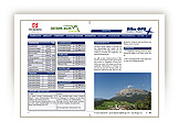
A dream tour to two magnificently located mountain pastures at the foot of the Sciliar. In the first part of the climb, the Lake- Laghetto di Fiè fascinates with its swimming facilities and impressive backdrop of mountains. You should allow plenty of time for a stop for refreshments on one of the two mountain pastures (Malga Tuff Alm and Malga Hofer Alpl). It is fantastically beautiful sitting on the terraces and soaking up the unforgettably clear views. By the way, you can cycle the short distance you push your bike after the Malga Tuff Alm, if you are fit enough!
Away from the main road you take the trail to San Costantino and for a start warm up unhurriedly. The climb to the Laghetto di Fiè does not follow the heavily trafficked road to the lake, but takes the car-free alternative coming from the north at first on tarmac and then on a track through woodland.
In this way you arrive quite unexpectedly at the bank of the Lake - Laghetto di Fiè right next to the guesthouse of the same name. You can stop for refreshments here or jump straight off the jetty into the picturesque lake immediately below the Sciliar/Schlern. A little further on you come across the bathing cabin with a large jetty.
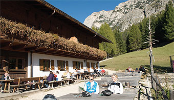
Initially, the route leads to the somewhat higher located Lake - Laghetto di Huber and then on through woodland uphill in the direction of the Malga Tuff Alm. It is 200m in altitude difference to the mountain pasture and whoever would like to rest here will be well-cared for on the panoramic terrace.
There follows a short descent across the mountain pasture before a gravel road, very steep in places, leads to the highest point of this tour, the cable car that carries goods to the Schlernhaus/Rifugio Bolzano. We have earmarked the first part of this climb as a section for pushing your bike, but physically fit bikers can of course cycle it!
A few bends further down on the road through woodland you reach the turn-off to the Malga Hofer Alpl. Anyway, you should stop here for refreshments at the very latest and take time to savour the peaceful, remote location and the glorious clear views as far as La Giogaia di Tessa group of mountains 50 kilometres distant.
The descent from the Malga Hofer Alpl to Umes is 500m in altitude difference. The old road from Umes to Fiè forms the crowning glory of this tour. This mostly gravelled, idyllic section leads through cropped fields, past old farmyards to Fiè in the most beautiful afternoon sunshine if the weather is fine.
Variations
1. Direct climb to the Lake- Laghetto di Fiè: At waymarker 5 in Sant’Antonio do not turn left, but right to the main road. Immediately opposite, the road to the lake begins. It is the shortest way to the Lake Laghetto di Fiè. Bear left shortly before the lake at Hotel Waldsee in the direction of the Guesthouse Laghetto di Fiè(Laghetto di Fiè), where you continue the tour described here at waymarker 19.
2. Shorter way back via Moarmühle (mill): Do not turn sharp left at waymarker 38, but follow the gravel road downhill through the following right-hand bend. 850m further on and a decrease of 100m in altitude difference you join the Umes road that follows on the right to the roundabout in Fiè.
3. Extension via the protruding rock of Monte Cavone/Tschafon: Whoever has not had enough at waymarker 42 above Umes should bear left in the direction of Monte Cavone/Tschafon. This additional loop leads again to Umes via the protruding rock of Monte Cavone/Tschafon, Schönblick, Tschötscher and Schnaggenkreuz where it joins the tour described here again at the sawmill (waymarker 46). For details s. tour “Sciliar/Schlern and Croda del Maglio/Hammerwand”. The loop is 12.5km in distance and 590m uphill in altitude difference.
|
| |
|
| |
TOUR INFORMATION
Tour information |
|
% of distance |
Total distance |
19,46 km |
100 % |
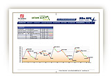
Height variation uphill |
826 Hm |
|
Height variation downhill |
826 Hm |
|
Maximum altitude |
1450 m |
|
Tarmac |
0,46 km |
| 2,4 % |
 |
|
Tarmac cycle path |
4,63 km |
23,8 %
|
 |
|
Gravel |
11,06 km |
| 56,9 % |
 |
|
Hiking trail |
2,29 km |
11,8 %
|
 |
|
Single track |
0,00 km |
0,0 %
|
 |
|
Carrying / pushing |
0,99 km |
5,1 %
|
 |
|
Cable car / transfer |
0,00 km |
0,0 %
|
 |
|
|
| |
|
|
Riding times |
Riding time without pauses |
Riding time at 10 km/h |
1 hr 57 min |
Riding time at 12 km/h |
1 hr 37 min |
Riding time at 14 km/h |
1 hr 23 min |
Riding time at 16 km/h |
1 hr 13 min |
Riding time at 18 km/h |
1 hr 05 min |
Riding time at 20 km/h |
58 min |
| |
|
| |
|
| |
|
| |
|
| |
|
|
|
| |
|
Physical condition |
|
|
Overall condition |
2,5 |
|
Total height variation |
3,0 |
|
Total distance |
2,0 |
|
Maximum altitude |
2,0 |
|
|
|
Riding technique |
|
|
Overall riding technique |
3,7 |
|
Surface |
3,7 |
|
Average climb gradient Ø |
4,0 |
|
Average descent gradient Ø |
3,0 |
|
|
|
| |
|
Tour evaluation |
|
|
Overall difficulty |
3,0 |
|
Climb difficulty |
3,1 |
|
Descent difficulty |
2,9 |
|
|
|
Emotional experience |
|
|
Panorama |
5,0 |
|
Riding fun |
3,0 |
|
| |
|
|
|
|
| |
|
GETTING THERE AND STARTING POINT
Getting there
Coming from the north take the motorway (A22) exit for Chiusa – Alpe di Siusi/Sciliar, SS12 as far as Ponte Gardena, then in the direction of Alpe di Siusi.
Coming from the south take motorway (A22) exit for Bolzano Nord – Alpe di Siusi/Sciliar, SS12 as far as Prato all'Isarco, then in the direction of Alpe di Siusi.
Starting point
There are several car parks and underground parking facilities in all villages. Parking spaces marked in blue are subject to charges. Tickets are available from the appropriate automatic machines. All other parking spaces are free of charge.
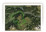
The tour begins at the tourism association Fiè.
|
| |
ROADBOOK
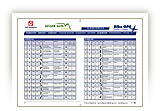
No |
km |
Next |
Hm |
Sym |
Location |
Direction |
Route |
Time 22 km/h |
Time 10 km/h |
1 |
0,00 |
0,05 |
859 |
|
Tourism association in Fiè |
Straight ahead direction way out of village |
|
00:00 |
00:00 |
2 |
0,05 |
0,51 |
857 |
|
Junction limit of Fiè |
Bear left on cycle path |
|
00:00 |
00:00 |
3 |
0,56 |
0,02 |
844 |
|
Water source |
Left |
|
00:01 |
00:03 |
4 |
0,58 |
0,38 |
846 |
|
Junction |
Straight ahead |
|
00:01 |
00:03 |
5 |
0,96 |
0,22 |
874 |
|
Car park Café Restaurant |
Bear left San Costantino |
|
00:02 |
00:05 |
6 |
1,18 |
0,33 |
886 |
|
Junction to Noval di Fiè |
Straight ahead |
|
00:03 |
00:07 |
7 |
1,50 |
0,08 |
872 |
|
Roundabout manufacturing district Sant’Antonio |
Bear left |
|
00:04 |
00:08 |
8 |
1,58 |
0,08 |
869 |
|
Junction |
Bear right |
|
00:04 |
00:09 |
9 |
1,66 |
0,86 |
876 |
|
End of manufacturing district |
Past roadside shrine on forest track |
|
00:04 |
00:09 |
10 |
2,52 |
0,08 |
895 |
|
End of forest track |
Bear right San Costantino |
|
00:06 |
00:15 |
11 |
2,60 |
0,32 |
900 |
|
Hotel Perwanger, water source |
Straight ahead San Costantino |
|
00:07 |
00:15 |
12 |
2,93 |
0,18 |
905 |
|
Near church San Costantino |
Straight ahead loop road cycle path |
|
00:07 |
00:17 |
13 |
3,10 |
0,15 |
902 |
|
Near Trafohäuschen (small house) |
Bear right Laghetto di Fiè, cycle path |
|
00:08 |
00:18 |
14 |
3,25 |
0,02 |
916 |
|
Crossroad |
Bear left main road (take footpath) |
|
00:08 |
00:19 |
15 |
3,27 |
0,62 |
917 |
|
Crossroad |
Bear right sign cul-de-sac |
|
00:08 |
00:19 |
16 |
3,90 |
0,17 |
956 |
|
Crossroad |
Bear left Lake- Laghetto di Fiè bike |
|
00:10 |
00:23 |
17 |
4,06 |
0,68 |
979 |
|
Crossroad |
Right Guesthouse Laghetto di Fiè Bike |
|
00:11 |
00:24 |
18 |
4,74 |
0,04 |
1048 |
|
Junction to Sant’Antonio |
Straight ahead |
|
00:12 |
00:28 |
19 |
4,78 |
0,09 |
1051 |
|
Guesthouse Laghetto di Fiè |
Left alongside lake |
|
00:13 |
00:28 |
20 |
4,87 |
0,37 |
1051 |
|
Junction to Seis (Siusi) 2 |
Right Sciliar/Schlern, Malg Tuff Alm, Malga Hofer Alpl |
|
00:13 |
00:29 |
21 |
5,24 |
0,04 |
1054 |
|
Climbing pole |
Left Bike |
|
00:14 |
00:31 |
22 |
5,28 |
0,24 |
1057 |
|
Junction to Umes |
Straight ahead Malga Tuff Alm |
|
00:14 |
00:31 |
23 |
5,52 |
0,75 |
1077 |
|
Laghetto di Huber |
Left alongside lake |
|
00:15 |
00:33 |
24 |
6,27 |
0,17 |
1077 |
|
Crossroads |
Sharp left uphill |
|
00:17 |
00:37 |
25 |
6,44 |
0,69 |
1096 |
|
Junction hiking trail 1 |
Straight ahead Malga Tuff Alm |
|
00:17 |
00:38 |
26 |
7,13 |
0,30 |
1167 |
|
Water source |
Straight ahead |
|
00:19 |
01:42 |
27 |
7,43 |
0,73 |
1200 |
|
Junction in bend |
Sharp right Malga Tuff Alm |
|
00:20 |
00:44 |
28 |
8,16 |
0,09 |
1278 |
|
Near Malga Tuff Alm |
Bear right to mountain pasture |
|
00:22 |
00:48 |
29 |
8,25 |
0,16 |
1273 |
|
Malga Tuff Alm |
Bear left across meadow |
|
00:22 |
00:49 |
30 |
8,41 |
0,99 |
1257 |
|
Crossroads in fields and meadows |
Bear left uphill Malga Hofer Alpl |
|
00:22 |
00:50 |
31 |
9,40 |
0,58 |
1387 |
|
Fork (to the Malga Hofer Alpl) |
Bear left Schlern (Sciliar) 1 |
|
00:25 |
00:56 |
32 |
9,98 |
0,86 |
1450 |
|
Goods cable car to Schlernhaus/Rifugio Bolzano |
Bear right Malga Hofer Alpl |
|
00:27 |
00:59 |
33 |
10,85 |
0,12 |
1366 |
|
Junction |
Sharp left Malga Hofer Alpl |
|
00:29 |
01:05 |
34 |
10,97 |
0,12 |
1349 |
|
Malga Hofer Alpl |
Back |
|
00:29 |
01:05 |
35 |
11,09 |
1,30 |
1366 |
|
Intersection |
Bear left downhill |
|
00:30 |
01:06 |
36 |
12,39 |
1,41 |
1226 |
|
Junction to the Malga Tuff Alm |
Sharp left downhill |
|
00:33 |
01:14 |
37 |
13,81 |
0,74 |
1095 |
|
Junction to Umes, Malga Hofer Alpl |
Sharp right downhill |
|
00:37 |
01:22 |
38 |
14,54 |
0,27 |
1013 |
|
Junction ahead of right-hand bend |
Sharp left loop road Umes |
|
00:39 |
01:27 |
39 |
14,82 |
0,29 |
1010 |
|
Junction |
Bear right downhill |
|
00:40 |
01:28 |
40 |
15,11 |
0,10 |
997 |
|
Fork |
Bear left |
|
00:41 |
01:30 |
41 |
15,21 |
0,31 |
1004 |
|
Intersection in bend |
Bear right downhill |
|
00:41 |
01:31 |
42 |
15,52 |
0,31 |
976 |
|
Intersection (water source) |
Sharp right downhill Umes |
|
00:42 |
01:33 |
43 |
15,83 |
0,09 |
942 |
|
Junction |
Right downhill to church |
|
00:43 |
01:34 |
44 |
15,92 |
0,12 |
933 |
|
Bus stop Umes |
Left Presule |
|
00:43 |
01:35 |
45 |
16,04 |
0,27 |
926 |
|
Maso Gstapinhof |
Left Presule 6 |
|
00:43 |
01:36 |
46 |
16,31 |
0,54 |
900 |
|
Sawmill |
Right Presule |
|
00:44 |
01:37 |
47 |
16,85 |
0,04 |
834 |
|
Junction to Presule |
Bear right downhill Prösels (Presule) 6 |
|
00:45 |
01:41 |
48 |
16,89 |
0,25 |
829 |
|
Wooden bridge |
Right Völs (Fiè) |
|
00:46 |
01:41 |
49 |
17,14 |
0,60 |
931 |
|
Maso Trafisöhr Hof |
Bear left downhill Fiè |
|
00:46 |
01:42 |
50 |
17,74 |
0,12 |
942 |
|
Junction |
Bear right |
|
00:48 |
01:46 |
51 |
17,86 |
0,10 |
838 |
|
Wooden bridge |
Left Völs (Fiè) 6 |
|
00:48 |
01:47 |
52 |
17,96 |
0,55 |
849 |
|
End of tarmac road |
Straight ahead |
|
00:48 |
01:47 |
53 |
18,51 |
0,14 |
853 |
|
Crossroad |
Straight ahead Fiè (Fiè) 6 |
|
00:50 |
01:51 |
54 |
18,65 |
0,39 |
866 |
|
Intersection tarmac road |
Bear left downhill Völs (Fiè) 6 |
|
00:50 |
01:51 |
55 |
19,04 |
0,38 |
841 |
|
Intersection main road |
Bear right uphill |
|
00:51 |
01:54 |
56 |
19,42 |
0,04 |
859 |
|
Roundabout Fiè |
Bear right Castelrotto (2nd exit) |
|
00:52 |
01:56 |
57 |
19,46 |
0,00 |
859 |
|
Tourism association Fiè |
End of tour |
|
00:53 |
01:56 |
EXPLANATION OF EVALUATION FACTORS, SURFACE AND SLOPE
Explanation of evaluation factors
• Overall difficulty based on climb difficulty (60%) and descent difficulty (40%)
• Climb difficulty based on total distance uphill (30%), overall height variation uphill (30%), surface uphill (10%), average slope uphill (25%), highest altitude reached (5%).
• Descent difficulty consists of total distance downhill (10%), overall height variation downhill (10%), surface downhill (50%), average slope downhill (30%).
• Physical condition based on total distance (40%), with overall height variation (50%) and highest altitude reached (10%).
• Riding technique based on surface (50%), with average slope uphill (30%) and average slope downhill (20%).
• Writer’s subjective evaluation of panorama and riding fun.
Explanation of surface and slope |
|
|
|
A = Tarmac road |
|
steep uphill |
from + 15% |
R = Tarmac cycle path |
|
uphill |
up to + 14% |
S = Gravel |
|
level |
ca. +/- 4% |
W = Hiking trail |
|
downhill |
up to - 19% |
P = Path, Single Trail |
|
steep downhill |
from - 20% |
T = Carrying / pushing |
|
|
|
X = Cable car / transfer |
|
|
|
Route: the percentages indicate the average climb (+) or the average descent (-) to the next waymarker. |
DOWNLOADS
| |
 |
 |
 |
 |
CHARACTERISTICS |
ALTITUDE PROFILE |
ROADBOOK |
MAP |
|
| |
|