|
CHARACTERISTICS AND VARIATIONS
Characteristics
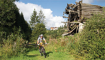
The tour of the Gardena valley features the three main towns of the valley in a diversified tour that is ideal for those starting mountain biking. Its course runs almost completely away from the more busy main road. The ascent on sections of the former railway line in the second part of the tour on the way back to Wolkenstein is especially pleasant. The gentle, steady incline that was necessary then for trains is very relaxing for bikers.
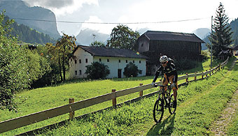
The tour begins at the tourism association in Wolkenstein. The route out of the valley mainly follows the left bank of rio (brook) Gardena. It begins on beautiful woodland and meadow paths directly along the brook and later between St. Christina and St. Ulrich on tarmac secondary roads with hardly any traffic. In this way you arrive at the promenade in St. Ulrich with almost no increase in altitude difference.
At the valley station of the Seiser Alm cable car you turn right, cross the main road via the pedestrian bridge and reach the centre of the village. From now on it is only uphill. Altogether, it is a good 450 metres difference in altitude to Wolkenstein, but the incline is very moderate and makes for a fantastic ride.
Shortly before St. Christina you come across La Pozza, a small village behind St. Christina, on the section you already know from the way there and that you now take in the opposite direction. The route changes there again to the other side of the valley and follows the old, abandoned railway line, that has been converted to a cycle path, back to Wolkenstein.
Variations
1. Alternative starting points: you can start the tour from any place in the valley, for example, even from St. Christina or Ortisei.
2. Short tour: already at waymarker 10 you can greatly shorten the tour by not bearing left here but going right to La Pozza. You continue the tour by a direct route at waymarker 57 (-13.6 km, -373 m altitude difference).
3. The way back via Anna valley (Annatal), St. Jakob and the valley station Col Raiser: the tour is decidedly more demanding, but also much more beautiful if you follow the signposts in St. Ulrich for the valley station Seceda and further on in the direction of the Annatal. Either you take the short detour to this stunningly located stop for refreshments, or at the Pauli mountain cabin turn immediately right in the direction of St. Jakob's church. The route continues via Insom to the Col Raiser valley station. A short descent takes you down to La Pozza, where you join the tour described here again at waymarker 59.
4. Extension into the Langental: Whoever, on the way back and just before Wolkenstein, has not yet had enough should not continue straight ahead on the old railway line at waymarker 61, but bear left for a short distance on the road. Turn left at the next traffic roundabout and from there on follow the road into the Langental. On the way back keep left at the car park at the mouth of the valley and go back to Wolkenstein again via the valley station Dantercepies.
|
| |
|
| |
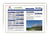
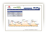
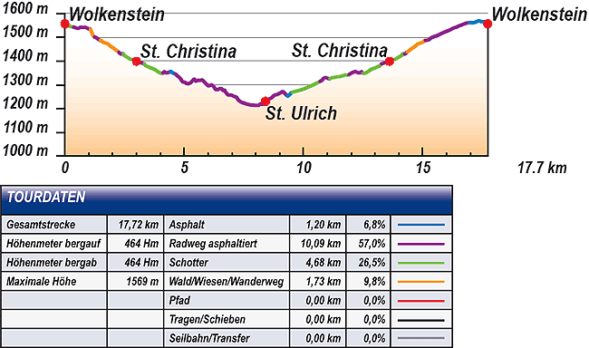
TOUR INFORMATION
Tour information |
|
% of distance |
Total distance |
17,72 km |
100 % |
Height variation uphill |
464 Hm |
|
Height variation downhill |
464 Hm |
|
Maximum altitude |
1569 m |
|
Tarmac |
1,20 km |
| 6,8 % |
 |
|
Tarmac cycle path |
10,09 km |
57,0 %
|
 |
|
Gravel |
4,68 km |
| 26,5 % |
 |
|
Hiking trail |
1,73 km |
9,8 %
|
 |
|
Single track |
0,00 km |
0,0 %
|
 |
|
Carrying / pushing |
0,00 km |
0,0 %
|
 |
|
Cable car / transfer |
0,00 km |
0,0 %
|
 |
|
|
| |
|
|
Riding times |
Riding time without pauses |
Riding time at 10 km/h |
1 hr 46 min |
Riding time at 12 km/h |
1 hr 29 min |
Riding time at 14 km/h |
1 hr 16 min |
Riding time at 16 km/h |
1 hr 06 min |
Riding time at 18 km/h |
59 min |
Riding time at 20 km/h |
53 min |
| |
|
| |
|
| |
|
| |
|
| |
|
|
|
| |
|
Physical condition |
|
|
Overall condition |
2,1 |
|
Total height variation |
2,0 |
|
Total distance |
2,0 |
|
Maximum altitude |
3,0 |
|
|
|
Riding technique |
|
|
Overall riding technique |
2,2 |
|
Surface |
2,5 |
|
Average climb gradient Ø |
2,0 |
|
Average descent gradient Ø |
2,0 |
|
|
|
| |
|
Tour evaluation |
|
|
Overall difficulty |
2,1 |
|
Climb difficulty |
2,1 |
|
Descent difficulty |
2,2 |
|
|
|
Emotional experience |
|
|
Panorama |
2,0 |
|
Riding fun |
2,0 |
|
| |
|
|
|
|
| |
|
GETTING THERE AND STARTING POINT
Getting there
Take Brenner motorway A22, coming from the north via Innsbruck-Brenner, or from the south via Verona-Bozen.
The best motorway exit is Klausen/Gröden. From there in about 20 minutes you can reach St Ulrich and a few kilometres further on St. Christina and Wolkenstein on a clearly signposted mountain road.
Starting point
The tourism association is located on the left about 500 m after you enter the village of Wolkenstein.
Parking is available at the the beginning of the village centre of Wolkenstein. Turn left before Nives Platz and then immediately left again into the Nives car park.
The tour begins at the tourism association Wolkenstein.
|
| |
ROADBOOK
No |
km |
Next |
Hm |
Sym |
Location |
Direction |
Route |
Time 22 km/h |
Time 10 km/h |
1 |
0,00 |
0,05 |
1557 |
|
Tourist information office in Wolkenstein/Selva |
Straight on downhill |
|
00:00 |
00:00 |
2 |
0,05 |
0,05 |
1554 |
|
Café Mozart |
Sharp left onto permanent hiking trail |
|
00:00 |
00:00 |
3 |
0,10 |
0,06 |
1550 |
|
Casa Elisabetha |
Sharp right downhill |
|
00:00 |
00:00 |
4 |
0,17 |
0,20 |
1548 |
|
End of tarmac |
Straight on |
|
00:00 |
00:00 |
5 |
0,37 |
0,08 |
1543 |
|
Fire station |
Straight on |
|
00:01 |
00:02 |
6 |
0,45 |
0,43 |
1540 |
|
House of Culture |
Bear left |
|
00:01 |
00:02 |
7 |
0,88 |
0,18 |
1541 |
|
Junction at signpost 30 |
Straight on |
|
00:02 |
00:05 |
8 |
1,06 |
0,19 |
1535 |
|
Junction with hiking trail |
Bear right to 22a |
|
00:02 |
00:06 |
9 |
1,24 |
0,24 |
1501 |
|
Beginning of tarmac |
Straight on |
|
00:03 |
00:07 |
10 |
1,48 |
0,35 |
1487 |
|
Haus Paladina |
Bear left to Fischburg 22a |
|
00:04 |
00:08 |
11 |
1,83 |
0,43 |
1471 |
|
Junction with hiking trail |
Straight on |
|
00:04 |
00:10 |
12 |
2,25 |
0,11 |
1438 |
|
Crossroads |
Straight on downhill |
|
00:06 |
00:13 |
13 |
2,36 |
0,08 |
1430 |
|
Wooden bridge |
Bear left along stream |
|
00:06 |
00:14 |
14 |
2,44 |
0,29 |
1432 |
|
Junction before subway |
Bear left along stream |
|
00:06 |
00:14 |
15 |
2,74 |
0,13 |
1409 |
|
Intersection with bottom of Sasslong lift |
Bear left along stream |
|
00:07 |
00:16 |
16 |
2,86 |
0,13 |
1405 |
|
Junction |
Bear left over the Rio Gardena stream |
|
00:07 |
00:17 |
17 |
3,00 |
0,04 |
1399 |
|
Bridge (towards Val Gardena Marketing in S. Cristina) |
Straight on through subway |
|
00:08 |
00:17 |
18 |
3,04 |
0,29 |
1399 |
|
Junction after subway under main road |
Straight on |
|
00:08 |
00:18 |
19 |
3,32 |
0,77 |
1389 |
|
Bottom of Monte Pana chairlift |
Straight on along stream |
|
00:09 |
00:19 |
20 |
4,10 |
0,06 |
1349 |
|
Bridge over stream (towards waterfall) |
Straight on uphill |
|
00:11 |
00:24 |
21 |
4,16 |
0,26 |
1355 |
|
Hofer Group |
Bear left |
|
00:11 |
00:24 |
22 |
4,42 |
0,21 |
1356 |
|
Crossing with main road |
Bear left onto main road |
|
00:12 |
00:26 |
23 |
4,63 |
0,32 |
1346 |
|
Junction |
Left into Via Mulin d’Odum |
|
00:12 |
00:27 |
24 |
4,95 |
0,79 |
1312 |
|
Transformer station |
Right over St. Ulrich/Ortisei bridge |
|
00:13 |
00:29 |
25 |
5,74 |
0,95 |
1321 |
|
Intersection with Via Jender |
Bear right downhill |
|
00:15 |
00:34 |
26 |
6,69 |
0,29 |
1278 |
|
Junction with hiking trail 19 towards Pedroc-Hartl |
Right downhill |
|
00:18 |
00:40 |
27 |
6,98 |
0,54 |
1257 |
|
Junction with Streda Furdenan |
Straight on |
|
00:19 |
00:41 |
28 |
7,52 |
0,47 |
1224 |
|
St. Ulrich/Ortisei playground |
Bear left on path along stream |
|
00:20 |
00:45 |
29 |
7,99 |
0,12 |
1214 |
|
Raiffeisenkasse Kastelruth (bank) |
Straight on along stream |
|
00:21 |
00:47 |
30 |
8,11 |
0,08 |
1214 |
|
Residence Oswald |
Straight on uphill to Alpe di Siusi cable car |
|
00:22 |
00:48 |
31 |
8,19 |
0,15 |
1220 |
|
Bottom of Seiser Alm/Alpe di Siusi cable car, St. Ulrich/Ortisei |
Sharp left to centre over footbridge |
|
00:22 |
00:49 |
32 |
8,34 |
0,04 |
1224 |
|
Hotel Adler |
Bear left into pedestrian area |
|
00:22 |
00:50 |
33 |
8,38 |
0,03 |
1229 |
|
Landesberufschule (Vocational Training Institute) |
Straight on |
|
00:22 |
00:50 |
34 |
8,41 |
0,08 |
1231 |
|
Tourist information office in St. Ulrich/Ortisei |
Right to St. Jakob/San Giacomo |
|
00:22 |
00:50 |
35 |
8,49 |
0,04 |
1236 |
|
Church of St. Ulrich/Ortisei |
Bear right after church |
|
00:23 |
00:50 |
36 |
8,54 |
0,60 |
1239 |
|
Pana car park |
Straight on (left past the car park entrance) |
|
00:23 |
00:51 |
37 |
9,14 |
0,20 |
1273 |
|
Junction streda Paul Grohmann |
Straight on downhill |
|
00:24 |
00:54 |
38 |
9,33 |
0,20 |
1253 |
|
Otco Sculptures |
Bear left to S. Cristina |
|
00:25 |
00:55 |
39 |
9,53 |
1,15 |
1270 |
|
Zebra crossing |
Bear right to S. Cristina |
|
00:25 |
00:57 |
40 |
10,68 |
0,22 |
1314 |
|
End of gravel path |
Straight on |
|
00:29 |
01:04 |
41 |
10,89 |
0,22 |
1330 |
|
Intersection in front of Hotel Diamant |
Bear right along zebra crossing |
|
00:29 |
01:5 |
42 |
11,12 |
0,57 |
1327 |
|
Crossing with main road |
Bear left to S. Cristina |
|
00:30 |
01:06 |
43 |
11,69 |
0,21 |
1340 |
|
Haus Alba |
Straight on over the zebra crossing |
|
00:31 |
01:10 |
44 |
11,90 |
0,28 |
1343 |
|
Spar |
Bear left to S. Cristina |
|
00:32 |
01:11 |
45 |
12,18 |
0,26 |
1356 |
|
Crossing with main road |
Straight on to Strada Plan dala Sia |
|
00:33 |
01:13 |
46 |
12,44 |
0,06 |
1355 |
|
Hofer Group |
Bear right downhill |
|
00:33 |
01:14 |
47 |
12,50 |
0,77 |
1349 |
|
Bridge over stream (towards waterfall) |
Straight on (no through road) |
|
00:34 |
01:15 |
48 |
13,27 |
0,29 |
1389 |
|
Bottom of Monte Pana chairlift |
Straight on along stream |
|
00:36 |
01:19 |
49 |
13,56 |
0,04 |
1399 |
|
Junction before subway under main road |
Straight on through subway |
|
00:36 |
01:21 |
50 |
13,60 |
0,13 |
1399 |
|
Bridge (towards Val Gardena Marketing in S. Cristina) |
Straight on |
|
00:34 |
01:21 |
51 |
13,73 |
0,13 |
1405 |
|
Intersection |
Bear right towards bottom of lift |
|
00:37 |
01:22 |
52 |
13,86 |
0,29 |
1409 |
|
Junction with bottom of Sasslong lift |
Bear right towards subway |
|
00:37 |
1:23 |
53 |
14,16 |
0,08 |
1432 |
|
Intersection |
Bear right along stream |
|
00:38 |
01:24 |
54 |
14,24 |
0,11 |
1430 |
|
Wooden bridge |
Bear right over bridge (residents access) |
|
00:38 |
01:25 |
55 |
14,35 |
0,43 |
1438 |
|
Crossroads |
Straight on along stream |
|
00:39 |
01:26 |
56 |
14,77 |
0,35 |
1471 |
|
Junction with hiking trail |
Straight on to Wolkenstein/Selva |
|
00:40 |
01:28 |
57 |
15,12 |
0,12 |
1487 |
|
Haus Paladina |
Left towards main road |
|
00:41 |
01:30 |
58 |
15,24 |
0,15 |
1489 |
|
Bar Adelaide, Crossing with main road |
Straight on Strada La Poza |
|
00:41 |
01:31 |
59 |
15,39 |
0,15 |
1500 |
|
Crossing with course of old railway |
Right |
|
00:41 |
01:32 |
60 |
15,55 |
0,28 |
1505 |
|
Crossing at Haus Lambolt |
Straight on over the zebra crossing |
|
00:42 |
01:33 |
61 |
15,83 |
0,58 |
1518 |
|
Crossing at Hotel Welponer |
Straight on to Wolkenstein/Selva |
|
00:43 |
01:34 |
62 |
16,41 |
0,48 |
1542 |
|
Hotel Sporting |
Straight on over road and follow cycle path |
|
00:44 |
01:38 |
63 |
16,89 |
0,08 |
1561 |
|
End of cycle path |
Straight on |
|
00:46 |
01:41 |
64 |
16,97 |
0,10 |
1562 |
|
Villa Gran Baita |
Straight on |
|
00:46 |
01:41 |
65 |
17,08 |
0,29 |
1561 |
|
Wolkenstein/Selva primary school |
Straight on strada Nives |
|
00:46 |
01:42 |
66 |
17,36 |
0,11 |
1569 |
|
Pizzaealtro |
Bear right onto main road |
|
00:47 |
1:44 |
67 |
17,47 |
0,09 |
1566 |
|
Hotel Krone |
Sharp right |
|
00:47 |
01:44 |
68 |
17,56 |
0,17 |
1566 |
|
Bottom of Ciampinoi lift |
Straight on |
|
00:47 |
01:45 |
69 |
17,72 |
0,00 |
1557 |
|
Tourist information office in Wolkenstein/Selva |
End of tour |
|
00:48 |
01:46 |
EXPLANATION OF EVALUATION FACTORS, SURFACE AND SLOPE
Explanation of evaluation factors
• Overall difficulty based on climb difficulty (60%) and descent difficulty (40%)
• Climb difficulty based on total distance uphill (30%), overall height variation uphill (30%), surface uphill (10%), average slope uphill (25%), highest altitude reached (5%).
• Descent difficulty consists of total distance downhill (10%), overall height variation downhill (10%), surface downhill (50%), average slope downhill (30%).
• Physical condition based on total distance (40%), with overall height variation (50%) and highest altitude reached (10%).
• Riding technique based on surface (50%), with average slope uphill (30%) and average slope downhill (20%).
• Writer’s subjective evaluation of panorama and riding fun.
Explanation of surface and slope |
|
|
|
A = Tarmac road |
|
steep uphill |
from + 15% |
R = Tarmac cycle path |
|
uphill |
up to + 14% |
S = Gravel |
|
level |
ca. +/- 4% |
W = Hiking trail |
|
downhill |
up to - 19% |
P = Path, Single Trail |
|
steep downhill |
from - 20% |
T = Carrying / pushing |
|
|
|
X = Cable car / transfer |
|
|
|
Route: the percentages indicate the average climb (+) or the average descent (-) to the next waymarker. |
DOWNLOADS
| |
 |
 |
 |
 |
CHARACTERISTICS |
ALTITUDE PROFILE |
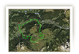
ROADBOOK |
MAP |
|
| |
|

