|
CHARACTERISTICS AND VARIATIONS
Characteristics
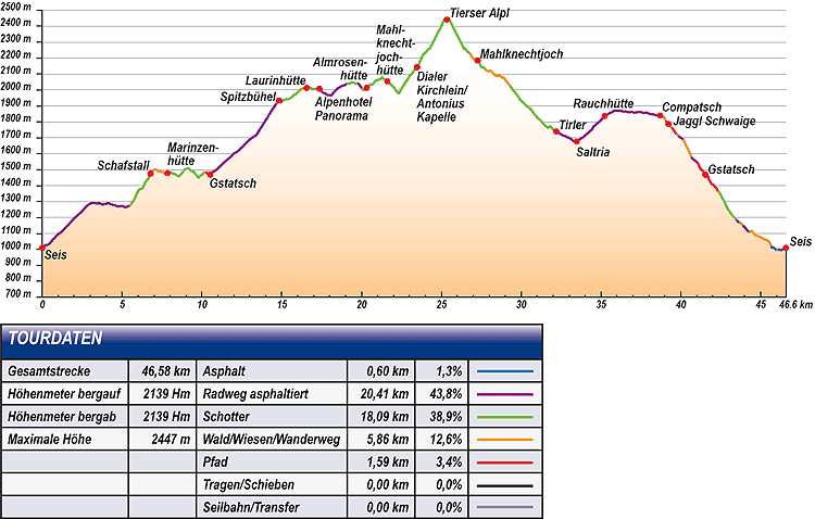
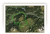
This is one of the most beautiful tours of the region and offers all that the hearts of mountain bikers desire. A long and varied climb over almost 2,000m in altitude difference offers a fitness challenge with stops for refreshment at some of the most beautiful mountain huts of the region. The destination is the Rifugio Alpe di Tires, the highest mountain hut of the region that can be reached by mountain bike in an incomparable location at the foot of the spectacular Denti di Terrarossa/Rosszähne. It also has a technically challenging descent that is waiting for you in the second part of the tour with several exhilarating trails and cart tracks on which riding technique fans will be in their element. A dream tour for physically fit and technically expert bikers! You can warm up easily in the first kilometres from the tourism association Siusi to the control station San Valentino on the small panoramic road leading to Wasserebene. On its gritty climb to the Schafstall the tour shows its teeth for the first time. 200m in altitude difference further up the nightmare is over for a start. The next section via Marinzen to Gstatsch is very easy and simply puts you in a good mood.
There follows a short training session. You grind up the next 250m in altitude difference on the Alpe di Siusi road, free of normal traffic since 9am, as far as the car park at Spitzbühel. There is no other sensible route here for bikers to take. From the Spitzbühel car park on it gets steeper again with an average 15% climb on a narrow tarmac path to the mountain station of the chair lift. The mountain hut there looks down over the valley as if from an eagle’s nest. The Santner peak appears, from the terrace, to be within your grasp as it forms the distinctive end of the Sciliar/Schlern to the north-west.
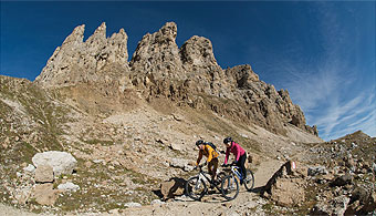
The panorama and mountain hutmarathon begins with the Spitzbühel up on the Alpe di Siusi. On your way via the Laurin hut, Alpenhotel Panorama, Almrosen hut, Mahlknechtjoch hut and the small church at Dialler, you cannot really see enough of the well-known Dolomite peaks, like the Sasso Lungo/Langkofel, Sasso Piatto/Plattkofel, Marmolada, Gruppo di Sella, Sas Rigais, Le Odle/Geißler, Denti di Terrarossa/Rosszähne, Sciliar/Schlern with the Santner peak. When the weather is good, you can see still further, e. g., as far as the Zillertal Alps and Alpi Breonie and as far as the Ortles/Ortler!
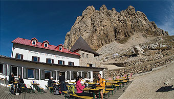
There are still now 300m in altitude difference from the small church at Dialler to the Alpe di Tires. The track over which the landlord of the mountain hut brings supplies is always in a good condition, but very steep. You have to deal with a climb of up to 20% in longer sections and with already many metres in altitude difference in your tired legs. But even if you have to dismount at some point, the Alpe di Tires as a destination is worth every effort. This dreamlike mountain hut is located completely remote at the foot of the Denti di Terrarossa/Rosszähne and offers a stunning panorama, e. g., of the Catinaccio/Rosengarten located opposite. The landlord and landlady are amiable and the food excellent. It is so beautiful up here that you would immediately like to stay overnight. And why not?
The same track then takes you back downhill over glorious trails in the direction of Mahlknechtjoch/Giogo. If the weather is good, the Marmolada will greet you from a distance. From the small church at Dialler a panoramic trail goes in the direction of Giogo. You cruise along relaxed over gravel and then a narrow tarmac road to Saltria where the last climb of this tour begins. This road takes you past the beautiful Rauchhütte (hut) as far as oampaccio.
Shortly below Compaccio a hiking trail turns off at the Gasthaus Zorzi in the direction of the Spitzbühel car park. After the Jaggl Schwaige this hiking trail turns into a fun trail that disgorges the bikers at the car park of the chair lift to the Spitzbühel.
From here riding technique fans are again in their element. The trail leading to Gstatsch is challenging. It is narrow, has obstacles and was in parts a former cart track. But take care! In the event of wet conditions or after rain, it is very slippery here.
From Gstatsch the fun descent continues. A narrow, secluded trail circles down in the direction of Bagni di Razzes. Only after crossing the Frommer brook, do you again come across civilisation in the form of a gravel road.
Somewhat below the Castelvecchio a very smooth-flowing trail begins. It ends at the car park of the Alpe di Siusi aerial cableway. From here you are still only a few minutes away from the starting point of this tour at the tourism association in Siusi.
Variations
1. Easier climb over the Alpe di Siusi road: Do not turn sharp left at the control point San Valentino (waymarker 8), but go straight ahead to Gstatsch. You join the tour described here again at waymarker 25.
2
. Leaving out Alpe di Tires: If you are not fit enough, it is already late or the weather is unfavourable you can shorten the tour shortly before the small church at Dialler. At waymarker 56 do not go straight ahead to the Alpe di Tires, but bear left to Giogo. This way you save yourself 320m in altitude difference and probably a good hour in time.
3. Ascent with the Alpe di Siusi aerial cableway: The tour becomes decidedly easier and shorter, if you take the Alpe di Siusi aerial cableway to Compaccio and grind up the tarmac road “Joch” beginning at the information office. You join the tour described here at waymarker 46 and save yourself almost 1,100m in altitude difference.
|
| |
|
| |
TOUR INFORMATION
Tour information |
|
% of distance |
Total distance |
46,58 km |
100 % |
Height variation uphill |
2139 Hm |
|
Height variation downhill |
2139 Hm |
|
Maximum altitude |
2447 m |
|
Tarmac |
0,60 km |
| 1,3 % |
 |
|
Tarmac cycle path |
20,41 km |
43,8 %
|
 |
|
Gravel |
18,09 km |
| 38,9 % |
 |
|
Hiking trail |
5,86 km |
12,6 %
|
 |
|
Single track |
1,59 km |
3,4%
|
 |
|
Carrying / pushing |
0,00 km |
0,0 %
|
 |
|
Cable car / transfer |
0,00 km |
0,0 %
|
 |
|
|
| |
|
|
Riding times |
Riding time without pauses |
Riding time at 10 km/h |
4 hrs 39 min |
Riding time at 12 km/h |
3 hrs 53 min |
Riding time at 14 km/h |
3 hrs 20 min |
Riding time at 16 km/h |
2 hrs 55 min |
Riding time at 18 km/h |
2 hrs 35 min |
Riding time at 20 km/h |
2 hrs 20 min |
| |
|
| |
|
| |
|
| |
|
| |
|
|
|
| |
|
Physical condition |
|
|
Overall condition |
4,5 |
|
Total height variation |
5,0 |
|
Total distance |
4,0 |
|
Maximum altitude |
4,0 |
|
|
|
Riding technique |
|
|
Overall riding technique |
3,5 |
|
Surface |
2,9 |
|
Average climb gradient Ø |
4,0 |
|
Average descent gradient Ø |
4,0 |
|
|
|
| |
|
Tour evaluation |
|
|
Overall difficulty |
4,0 |
|
Climb difficulty |
4,1 |
|
Descent difficulty |
3,8 |
|
|
|
Emotional experience |
|
|
Panorama |
5,0 |
|
Riding fun |
5,0 |
|
| |
|
|
|
|
| |
|
GETTING THERE AND STARTING POINT
Getting there
Coming from the north take the motorway (A22) exit for Chiusa – Alpe di Siusi/Sciliar, SS12 as far as Ponte Gardena, then in the direction of Alpe di Siusi.
Coming from the south take motorway (A22) exit for Bolzano Nord – Alpe di Siusi/Sciliar, SS12 as far as Prato all'Isarco, then in the direction of Alpe di Siusi.
Starting point
There are several car parks and underground parking facilities in all villages. Parking spaces marked in blue are subject to charges. Tickets are available from the appropriate automatic machines. All other parking spaces are free of charge.
The tour begins at the tourism association Siusi.
|
| |
ROADBOOK
No |
km |
Next |
Hm |
Sym |
Location |
Direction |
Route |
Time 22 km/h |
Time 10 km/h |
1 |
0,00 |
0,03 |
1010 |
|
Tourism association Siusi, bus stop |
Straight ahead |
|
00:00 |
00:00 |
2 |
0,03 |
0,57 |
1017 |
|
Junction |
Right Henrik-Ibsen-Str. |
|
00:00 |
00:00 |
3 |
0,60 |
0,38 |
1054 |
|
Junction with Via Fasslfun |
Bear right uphill |
|
00:01 |
00:03 |
4 |
0,99 |
0,16 |
1095 |
|
Crossroads |
Left Castelrotto 6 |
|
00:02 |
00:05 |
5 |
1,15 |
0,17 |
1105 |
|
Junction to Kastelruth (Castelrotto) 6 |
Bear right uphill |
|
00:03 |
00:06 |
6 |
1,32 |
1,10 |
1121 |
|
Junction with Via Burgstall |
Straight ahead uphill Rier |
|
00:03 |
00:07 |
7 |
2,42 |
0,57 |
1231 |
|
Haus Waldrand, bus stop |
Sharp right Alpe di Siusi |
|
00:06 |
00:14 |
8 |
2,99 |
0,51 |
1286 |
|
Control point San Valentino |
Sharp left Marinzen 11 |
|
00:08 |
00:17 |
9 |
3,50 |
0,60 |
1288 |
|
Junction to Marinzen |
Straight ahead Kastelruth (Castelrotto) 4 |
|
00:09 |
00:20 |
10 |
4,09 |
1,42 |
1291 |
|
Feldheim |
Straight ahead Castelrotto |
|
00:11 |
00:24 |
11 |
5,52 |
0,09 |
1277 |
|
Junction |
Bear right uphill Marinzen mountain cabin |
|
00:15 |
00:33 |
12 |
5,61 |
0,65 |
1292 |
|
Junction |
Straight ahead |
|
00:15 |
00:33 |
13 |
6,26 |
0,21 |
1382 |
|
Junction to the Wasserebene |
Straight ahead Schafstall 8 |
|
00:17 |
00:37 |
14 |
6,47 |
0,31 |
1424 |
|
Junction |
Straight ahead uphill Schafstall 8 |
|
00:17 |
00:38 |
15 |
6,78 |
1,06 |
1476 |
|
Schafstall |
Sharp right Marinzen |
|
00:18 |
00:40 |
16 |
7,84 |
0,12 |
1478 |
|
Near Marinzen mountain cabin |
Sharp left Gstatsch |
|
00:21 |
00:47 |
17 |
7,96 |
0,16 |
1482 |
|
Junction to Gola, Alpe di Siusi |
Right Gstatsch |
|
00:21 |
00:47 |
18 |
8,12 |
0,27 |
1480 |
|
Junction to Seis (Suisi) 11 |
Straight ahead |
|
00:22 |
00:48 |
19 |
8,40 |
0,16 |
1467 |
|
Junction footpath 10 to Gstatsch |
Straight ahead Gstatsch |
|
00:22 |
00:50 |
20 |
8,56 |
0,08 |
1457 |
|
Junction gravel road |
Bear left Gstatsch 10 |
|
00:23 |
00:51 |
21 |
8,63 |
1,47 |
1466 |
|
Junction hiking trail 10 |
Straight ahead |
|
00:23 |
00:51 |
22 |
10,10 |
0,18 |
1480 |
|
Junction footpath to Marinzen |
Straight ahead |
|
00:27 |
01:00 |
23 |
10,28 |
0,20 |
1484 |
|
Single track junction |
Bear right downhill |
|
00:28 |
01:01 |
24 |
10,48 |
0,04 |
1466 |
|
Bench |
Bear left uphill |
|
00:28 |
01:02 |
25 |
10,53 |
0,50 |
1469 |
|
Gstatsch |
Sharp left Alpe di Siusi road |
|
00:28 |
01:03 |
26 |
11,03 |
0,31 |
1512 |
|
Crossroads hiking trail |
Straight ahead |
|
00:30 |
01:06 |
27 |
11,34 |
0,40 |
1542 |
|
Crossroads hiking trail |
Straight ahead |
|
00:30 |
01:08 |
28 |
11,74 |
1,25 |
1575 |
|
Crossroads hiking trail |
Straight ahead |
|
00:32 |
01:10 |
29 |
12,98 |
0,10 |
1688 |
|
Junction to Kastelruth, Seis (Castelrotto, Siusi) 4 |
Straight ahead Seiser Alm (Alpe di Siusi) 4 |
|
00:35 |
01:17 |
30 |
13,09 |
0,20 |
1696 |
|
Junction to the Marinzen mountain cabin (small car park) |
Straight ahead |
|
00:35 |
01:18 |
31 |
13,29 |
0,50 |
1710 |
|
Bend car park Punta di Razzes, bus stop |
Bear right across the car park |
|
00:36 |
01:19 |
32 |
13,78 |
0,93 |
1777 |
|
Junction gravel road |
Straight ahead uphill |
|
00:37 |
01:22 |
33 |
14,71 |
0,11 |
1921 |
|
Junction |
Right Punta di Razzes |
|
00:40 |
01:28 |
34 |
14,82 |
0,11 |
1935 |
|
Punta di Razzes |
Back |
|
00:40 |
01:28 |
35 |
14,93 |
0,09 |
1921 |
|
Intersection |
Bear right uphill |
|
00:40 |
01:29 |
36 |
15,02 |
0,09 |
1933 |
|
Junction |
Straight ahead uphill |
|
00:40 |
01:30 |
37 |
15,11 |
0,53 |
1939 |
|
Junction to the Schlernhaus / Rifugio Bolzano |
Bear left Laurin mountain cabin |
|
00:41 |
01:30 |
38 |
15,64 |
0,09 |
1957 |
|
Bench, table |
Straight ahead Laurin hut |
|
00:42 |
01:33 |
39 |
15,73 |
0,56 |
1964 |
|
Junction |
Bear left Laurinhut |
|
00:42 |
01:34 |
40 |
16,29 |
0,27 |
2012 |
|
Junction to Sattler Schwaige/Malga Sattler |
Bear left Goldknopf / Punta d´oro |
|
00:44 |
01:37 |
41 |
16,56 |
0,19 |
2013 |
|
Laurinhut |
Right |
|
00:45 |
01:39 |
42 |
16,75 |
0,50 |
2015 |
|
Junction to Sattler Schwaige |
Left |
|
00:45 |
01:40 |
43 |
17,25 |
0,03 |
2011 |
|
Junction Tierser Alpl (Rifugio Alpe di Tires) 2 |
Straight ahead |
|
00:47 |
01:43 |
44 |
17,28 |
0,08 |
2011 |
|
Mountain station Panorama |
Straight ahead |
|
00:47 |
01:43 |
45 |
17,35 |
0,29 |
2007 |
|
Alpenhotel Panorama |
Bear right |
|
00:47 |
01:44 |
46 |
17,64 |
0,01 |
1980 |
|
Intersection tarmac road |
Sharp right Goldknopf |
|
00:48 |
01:45 |
47 |
17,65 |
0,92 |
1980 |
|
Junction to Malga Ritsch Schwaige |
Straight ahead |
|
00:48 |
01:45 |
48 |
18,57 |
0,54 |
2014 |
|
Junction to the guesthouse Panorama |
Straight ahead uphill |
|
00:50 |
01:51 |
49 |
19,11 |
0,69 |
2041 |
|
Junction to the Goldknopf |
Bear left Saltria, Mahlknechtjoch hut |
|
00:52 |
01:54 |
50 |
19,80 |
0,24 |
2041 |
|
Beginning of tarmac |
Straight ahead |
|
00:53 |
01:58 |
51 |
20,04 |
0,29 |
2007 |
|
End of tarmac |
Straight ahead |
|
00:54 |
02:00 |
52 |
20,32 |
1,29 |
2013 |
|
Almrosen mountain cabin |
Straight ahead Mahlknechtjoch hut, Dialer refuge |
|
00:55 |
02:01 |
53 |
21,61 |
0,69 |
2054 |
|
Mahlknechtjoch hut (Molignon Refuge) |
Bear left Saltria 8 |
|
00:58 |
02:09 |
54 |
22,31 |
0,79 |
1980 |
|
Junction to Saltria (seat) |
Straight ahead Rifugio Alpe di Tires |
|
01:00 |
02:13 |
55 |
23,09 |
0,26 |
2096 |
|
Junction hiking trail to Mahlknechtjoch hut |
Straight ahead Rifugio Alpe di Tires |
|
01:02 |
02:18 |
56 |
23,35 |
0,12 |
2130 |
|
Below the small church at Dialler (St. Anton Chapel) |
Straight ahead Rifugio Alpe di Tires |
|
01:03 |
02:20 |
57 |
23,47 |
0,42 |
2143 |
|
Small church at Dialler (St. Anton Chapel)
|
Bear right Rifugio Alpe di Tires |
|
01:04 |
02:20 |
58 |
23,89 |
1,39 |
2226 |
|
Electric fence, junction to the Sasso Piatto hut |
Straight ahead Rifugio Alpe di Tires |
|
01:05 |
02:23 |
59 |
25,28 |
0,06 |
2447 |
|
Junction to the Denti di Terrarossa wind gap |
Bear left Rifugio Alpe di Tires 4 |
|
01:08 |
02:31 |
60 |
25,35 |
0,06 |
2442 |
|
Rifugio Alpe di Tires |
Back |
|
01:09 |
02:32 |
61 |
25,41 |
1,39 |
2447 |
|
Junction to the Denti di Terrarossa wind gap |
Bear right Dialer 4 |
|
01:09 |
02:32 |
62 |
26,81 |
0,38 |
2226 |
|
Electric fence |
Right Sasso Piatto hut |
|
01:13 |
02:40 |
63 |
27,19 |
0,08 |
2186 |
|
Junction |
Bear left level |
|
01:14 |
02:43 |
64 |
27,27 |
0,35 |
2185 |
|
Mahlknechtjoch / Passo Duron |
Left uphill |
|
01:14 |
02:43 |
65 |
27,62 |
0,12 |
2143 |
|
Small church Dialler (St. Anton Chapel) |
Right |
|
01:15 |
02:45 |
66 |
27,75 |
0,25 |
2130 |
|
Below small church at Dialler |
Sharp right Joch |
|
01:15 |
02:46 |
67 |
28,00 |
1,33 |
2119 |
|
Junction Sasso Piatto mountain cabin |
Straight ahead |
|
01:16 |
02:47 |
68 |
29,33 |
1,12 |
2021 |
|
Intersection |
Sharp left Saltria |
|
01:19 |
02:55 |
69 |
30,45 |
0,30 |
1891 |
|
Intersection in bend |
Bear left downhill |
|
01:23 |
03:02 |
70 |
30,75 |
1,07 |
1859 |
|
Intersection in bend |
Bear left downhill |
|
01:23 |
03:04 |
71 |
31,82 |
0,37 |
1772 |
|
Intersection |
Straight ahead Malga Tirler, Saltria |
|
01:26 |
03:10 |
72 |
32,19 |
0,80 |
1740 |
|
Guesthouse Malga Tirler |
Straight ahead |
|
01:27 |
03:13 |
73 |
33,00 |
0,48 |
1701 |
|
Junction Hans and Paula Steger trail |
Straight ahead Hans and Paula Steger trail |
|
01:29 |
03:17 |
74 |
33,48 |
1,74 |
1678 |
|
Intersection Hotel Saltria |
Left uphill Compatsch |
|
01:31 |
03:20 |
75 |
35,22 |
0,47 |
1836 |
|
Junction to Rauch mountain cabin |
Bear left uphill |
|
01:36 |
03:31 |
76 |
35,70 |
0,90 |
1862 |
|
Crossroads with bus stop |
Right follow road |
|
01:37 |
03:34 |
77 |
36,60 |
1,07 |
1864 |
|
Junction to the Piz |
Straight ahead Compaccio |
|
01:39 |
03:39 |
78 |
37,67 |
1,00 |
1856 |
|
Junction to Hotel Steger Dellai |
Straight ahead |
|
01:42 |
03:46 |
79 |
38,68 |
0,03 |
1841 |
|
Tourist Info Compaccio |
Straight ahead |
|
01:45 |
03:52 |
80 |
38,70 |
0,24 |
1841 |
|
Compaccio |
Straight ahead |
|
01:45 |
03:52 |
81 |
38,94 |
0,03 |
1827 |
|
Junction |
Left Gasthaus Zorzi |
|
01:46 |
03:53 |
82 |
38,97 |
0,12 |
1826 |
|
Gasthaus Zorzi |
Right car park Spitzbühel |
|
01:46 |
03:53 |
83 |
39,09 |
0,13 |
1802 |
|
Beginning of tarmac road |
Straight ahead |
|
01:46 |
03:54 |
84 |
39,22 |
0,22 |
1787 |
|
Malga Jaggl Schwaige |
Straight ahead downhill |
|
01:46 |
03:55 |
85 |
39,45 |
0,31 |
1761 |
|
Hotel Seelaus |
Straight ahead car park Spitzbühel, Castelrotto 4 |
|
01:47 |
03:56 |
86 |
39,75 |
0,11 |
1723 |
|
Above car park Spitzbühel |
Straight ahead along fence |
|
01:48 |
03:58 |
87 |
39,86 |
0,20 |
1710 |
|
Bend car park Spitzbühel, bus stop |
Straight ahead downhill Alpe di Siusi road |
|
01:48 |
03:59 |
88 |
40,06 |
0,10 |
1696 |
|
Junction to the Marinzen hut (small car park) |
Straight ahead |
|
01:49 |
04:00 |
89 |
40,16 |
0,50 |
1688 |
|
Junction |
Bear left Castelrotto, Seis 4 |
|
01:49 |
04:00 |
90 |
40,67 |
0,40 |
1575 |
|
Crossroad |
Sharp left Alpe di Siusi road |
|
01:50 |
04:04 |
91 |
41,07 |
0,37 |
1542 |
|
Junction |
Bear left downhill 4 |
|
01:51 |
04:06 |
92 |
41,43 |
0,10 |
1481 |
|
Junction single track |
Straight ahead downhill |
|
01:53 |
04:08 |
93 |
41,53 |
0,18 |
1469 |
|
Gstatsch |
Sharp left downhill Alpe di Siusi road |
|
01:53 |
04:09 |
94 |
41,71 |
0,08 |
1457 |
|
Bend 3 |
Left Bagni di Razzes |
|
01:53 |
04:10 |
95 |
41,79 |
0,51 |
1433 |
|
Crossroads riding trail |
Left |
|
01:53 |
04:10 |
96 |
42,30 |
0,04 |
1368 |
|
Junction hiking trail |
Bear Left Bagni di Razzes 9 |
|
01:55 |
04:13 |
97 |
42,34 |
0,09 |
1364 |
|
Bridge over brook |
Right cross bridge over brook |
|
01:55 |
04:14 |
98 |
42,44 |
0,58 |
1353 |
|
Intersection gravel road |
Right |
|
01:55 |
04:14 |
99 |
43,01 |
0,23 |
1244 |
|
Junction hiking trail to Bagni di Razzes |
Straight ahead |
|
01:57 |
04:18 |
100 |
43,24 |
0,14 |
1210 |
|
Junction in bend (nature park boundary) |
Sharp left downhill |
|
01:57 |
04:19 |
101 |
43,39 |
0,12 |
1197 |
|
Crossroad |
Bear right downhill |
|
01:58 |
04:20 |
102 |
43,50 |
0,18 |
1182 |
|
Intersection to Bagni di Razzes trail (bench) |
Bear right downhill |
|
01:58 |
04:21 |
103 |
43,68 |
0,09 |
1167 |
|
Junction |
Bear left level |
|
01:59 |
04:22 |
104 |
43,77 |
0,13 |
1165 |
|
Fork water reservoir |
Bear right Seis (Siusi) 1 |
|
01:59 |
04:22 |
105 |
43,90 |
0,40 |
1148 |
|
Road junction |
Bear left downhill |
|
01:59 |
04:23 |
106 |
44,30 |
0,14 |
1109 |
|
Junction gravel road |
Bear left Siusi cable car |
|
02:00 |
04:25 |
107 |
44,45 |
0,25 |
1117 |
|
Junction to Castelvecchio |
Straight ahead Ruine Salegg 3 |
|
02:01 |
04:26 |
108 |
44,70 |
0,68 |
1086 |
|
Plaque on life expectancy |
Straight ahead |
|
02:01 |
04:28 |
109 |
45,38 |
0,31 |
1060 |
|
Crossroad |
Sharp right downhill (later 3B) |
|
02:03 |
04:32 |
110 |
45,69 |
0,07 |
1012 |
|
Car park Alpe di Siusi cable car |
Bear right across the car park |
|
02:04 |
04:34 |
111 |
45,76 |
0,15 |
1012 |
|
Valley station Alpe di Siusi cable car |
Sharp left |
|
02:04 |
04:34 |
112 |
45,91 |
0,13 |
1004 |
|
Junction Oswald von Wolkenstein trail |
Right downhill |
|
02:05 |
04:35 |
113 |
46,04 |
0,11 |
995 |
|
Bridge over brook, entrance car park Alpe di Siusi aerial cableway |
Straight ahead over bridge |
|
02:05 |
04:36 |
114 |
46,15 |
0,11 |
999 |
|
Junction private road |
Bear left Siusi |
|
02:05 |
04:36 |
115 |
46,26 |
0,02 |
995 |
|
Crossroad Matzlstr. |
Bear left to main road |
|
02:06 |
04:37 |
116 |
46,28 |
0,24 |
995 |
|
Garni Hauenstein |
Right |
|
02:06 |
04:37 |
117 |
46,52 |
0,06 |
1006 |
|
Roundabout Siusi |
Straight ahead Castelrotto |
|
02:06 |
04:39 |
118 |
46,58 |
0,00 |
1010 |
|
Tourism association Siusi, bus station |
End of tour |
|
02:07 |
04:39 |
EXPLANATION OF EVALUATION FACTORS, SURFACE AND SLOPE
Explanation of evaluation factors
• Overall difficulty based on climb difficulty (60%) and descent difficulty (40%)
• Climb difficulty based on total distance uphill (30%), overall height variation uphill (30%), surface uphill (10%), average slope uphill (25%), highest altitude reached (5%).
• Descent difficulty consists of total distance downhill (10%), overall height variation downhill (10%), surface downhill (50%), average slope downhill (30%).
• Physical condition based on total distance (40%), with overall height variation (50%) and highest altitude reached (10%).
• Riding technique based on surface (50%), with average slope uphill (30%) and average slope downhill (20%).
• Writer’s subjective evaluation of panorama and riding fun.
Explanation of surface and slope |
|
|
|
A = Tarmac road |
|
steep uphill |
from + 15% |
R = Tarmac cycle path |
|
uphill |
up to + 14% |
S = Gravel |
|
level |
ca. +/- 4% |
W = Hiking trail |
|
downhill |
up to - 19% |
P = Path, Single Trail |
|
steep downhill |
from - 20% |
T = Carrying / pushing |
|
|
|
X = Cable car / transfer |
|
|
|
Route: the percentages indicate the average climb (+) or the average descent (-) to the next waymarker. |
DOWNLOADS
| |
 |
 |
 |
 |
CHARACTERISTICS |
ALTITUDE PROFILE |
ROADBOOK |
MAP |
|
| |
|