|
CHARACTERISTICS AND VARIATIONS
Characteristics
This route is not a separate tour, but a link from the region of Alpe di Siusi to the cycle path in the Valle Isarco, the principal axis from Brennero in the direction of Bolzano.
It starts at the tourism association in Fiè. You follow the gravel trail parallel to the main road leading to Siusi for a short distance. After a short time you branch off on a tarmac secondary road leading to Novale di Fiè. A good five kilometres further and five hundred metres lower in altitude an old covered wooden bridge over the Isarco leads to the cycle path through the Valle Isarco.
Variations
1. In the opposite direction this route serves as an climb to the Alpe di Siusi region.
2. All tours beginning in Fiè can also start in the Valle Isarco.
|
| |
|
| |
TOUR INFORMATION
Tour information |
|
% of distance |
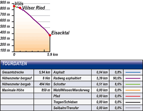
Total distance |
5,94 km |
100 % |
Height variation uphill |
8 Hm |
|
Height variation downhill |
494 Hm |
|
Maximum altitude |
859 m |
|
Tarmac |
0,04 km |
| 0,8 % |
 |
|
Tarmac cycle path |
5,39 km |
90,6 %
|
 |
|
Gravel |
0,51 km |
| 8,6 % |
 |
|
Hiking trail |
0,00 km |
0,0 %
|
 |
|
Single track |
0,00 km |
0,0 %
|
 |
|
Carrying / pushing |
0,00 km |
0,0 %
|
 |
|
Cable car / transfer |
0,00 km |
0,0 %
|
 |
|
|
| |
|
|
Riding times |
Riding time without pauses |
Riding time at 10 km/h |
36 min |
Riding time at 12 km/h |
30 min |
Riding time at 14 km/h |
25 min |
Riding time at 16 km/h |
22 min |
Riding time at 18 km/h |
20 min |
Riding time at 20 km/h |
18 min |
| |
|
| |
|
| |
|
| |
|
| |
|
|
|
| |
|
Physical condition |
|
|
Overall condition |
1,0 |
|
Total height variation |
1,0 |
|
Total distance |
1,0 |
|
Maximum altitude |
1,0 |
|
|
|
Riding technique |
|
|
Overall riding technique |
2,2 |
|
Surface |
2,1 |
|
Average climb gradient Ø |
2,0 |
|
Average descent gradient Ø |
3,0 |
|
|
|
| |
|
Tour evaluation |
|
|
Overall difficulty |
1,8 |
|
Climb difficulty |
1,4 |
|
Descent difficulty |
2,3 |
|
|
|
Emotional experience |
|
|
Panorama |
2,0 |
|
Riding fun |
1,0 |
|
| |
|
|
|
|
| |
|
GETTING THERE AND STARTING POINT
Getting there
Coming from the north take motorway (A22) exit for Chiusa – Alpe di Siusi/Sciliar, SS12 as far as Ponte Gardena, then in the direction of Alpe di Siusi.
Coming from the south take motorway (A22) exit for Bolzano Nord - Alpe di Siusi/Sciliar, SS12 as far as Prato all'Isarco, then in direction of Alpe di Siusi.
Starting point
There are several car parks and underground parking facilities in all villages. Parking spaces marked in blue are subject to charges. Tickets are available from the appropriate automatic machines. All other parking spaces are free of charge.
The tour begins at the tourism association in Fiè. |
| |
ROADBOOK
No |
km |
Next |
Hm |
Sym |
Location |
Direction |
Route |
Time 22 km/h |
Time 10 km/h |
1 |
0,00 |
0,05 |
859 |
|
Tourism association in Fiè |
Straight ahead towards end of village |
|
00:00 |
00:00 |
2 |
0,05 |
0,51 |
857 |
|
Junction on leaving Fiè |
Bear left on cycle path |
|
00:00 |
00:00 |
3 |
0,56 |
0,02 |
844 |
|
Fountain |
Left |
|
00:01 |
00:03 |
4 |
0,58 |
0,40 |
846 |
|
Junction |
Bear left |
|
00:01 |
00:03 |
5 |
0,98 |
0,52 |
831 |
|
Novale di Fiè (hairpin bend) |
Straight ahead downhill (Valle Isarco) |
|
00:02 |
00:05 |
6 |
1,51 |
0,37 |
791 |
|
Junction at Pardeller Hof |
Bear left downhill |
|
00:04 |
00:09 |
7 |
1,87 |
0,62 |
766 |
|
Morterèl Novàl di Fiè |
Left downhill Atzwang (Campodazzo) 3 |
|
00:05 |
00:11 |
8 |
2,50 |
0,54 |
712 |
|
Junction 9 - 10 |
Right downhill |
|
00:06 |
00:14 |
9 |
3,04 |
1,75 |
660 |
|
Junction to Campodazzo |
Straight ahead downhill |
|
00:08 |
00:18 |
10 |
4,79 |
1,16 |
501 |
|
Junction to Grottner |
Straight ahead downhill |
|
00:13 |
00:28 |
11 |
5,95 |
0,00 |
373 |
|
Intersection with cycle path Valle dell'Isarco |
End of tour |
|
00:16 |
00:35 |
EXPLANATION OF EVALUATION FACTORS, SURFACE AND SLOPE
Explanation of evaluation factors
• Overall difficulty based on climb difficulty (60%) and descent difficulty (40%)
• Climb difficulty based on total distance uphill (30%), overall height variation uphill (30%), surface uphill (10%), average slope uphill (25%), highest altitude reached (5%).
• Descent difficulty consists of total distance downhill (10%), overall height variation downhill (10%), surface downhill (50%), average slope downhill (30%).
• Physical condition based on total distance (40%), with overall height variation (50%) and highest altitude reached (10%).
• Riding technique based on surface (50%), with average slope uphill (30%) and average slope downhill (20%).
• Writer’s subjective evaluation of panorama and riding fun.
Explanation of surface and slope |
|
|
|
A = Tarmac road |
|
steep uphill |
from + 15% |
R = Tarmac cycle path |
|
uphill |
up to + 14% |
S = Gravel |
|
level |
ca. +/- 4% |
W = Hiking trail |
|
downhill |
up to - 19% |
P = Path, Single Trail |
|
steep downhill |
from - 20% |
T = Carrying / pushing |
|
|
|
X = Cable car / transfer |
|
|
|
Route: the percentages indicate the average climb (+) or the average descent (-) to the next waymarker. |
DOWNLOADS
| |
 |
 |
 |
 |
CHARACTERISTICS |
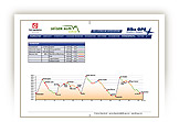
ALTITUDE PROFILE |
ROADBOOK |
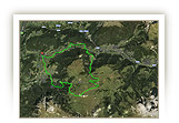
MAP |
|
| |
|