|
CHARACTERISTICS AND VARIATIONS
Characteristics
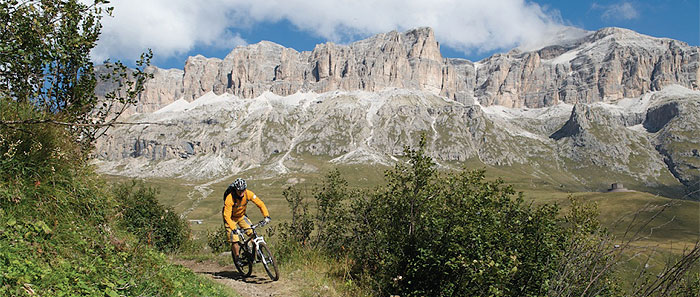
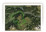
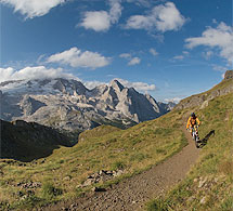
What has enthused skiers from all over the world for decades is now also valid in summer for mountain bikers, for example circumnavigating the impressive Sella massif in one day. Altogether five mountain cable cars make this possible by reducing the almost 4,000m in altitude difference, which you would otherwise have to struggle up, to a tolerable 800m of altitude difference. In this way, what would have been an impossible undertaking for the average biker becomes an unusual dream tour with unforgettable panoramas in the world natural heritage Dolomite Mountains and an enormous amount of fun going downhill with relatively little effort to go uphill.
After a short warming-up ride from Wolkenstein to the mouth of the Langental the cable car takes bikers to the mountain station of Dantercepies. You will have a little time on the gravel road leading to the Grödnerjoch to prepare yourself for the following descent. For immediately at the Grödnerjoch the first challenge for riding technique on this tour begins. The single trail leading to Colfosco offers 300m in altitude difference of the very best fun to be had with descents. Take care in the upper part! It goes over a few board walks that can be very slippery when wet. Apart from that, you know immediately after this first section that you have chosen exactly the right tour for the day! The next descent to Corvara passes by the distinctive crevice of the Mittagstal (valley), that rises up to the highest peak of the Sella mountain range, the Piz Boé.
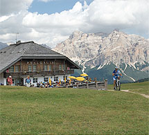
The second mountain cable car is already waiting for you in Corvara: the cable car to the Col Alto. The mountain station offers a stunning view of the south walls of the Sassongher located opposite. After a short descent, a chair lift takes you up the first part of the ascent to the Bioch Hütte (mountain cabin). The following section of the tour via the Bioch Hütte to Pralongia offers a lot of variety in trails and meadow paths, but also uphill steps as well as fantastic mountain views, such as that of the Piz Boé, or a view of the Marmolada. Whoever would like to enjoy this properly, should stop off here for something to eat. Pralongia mountain cabin or – after a short steep descent on the gravel road – the La Marmotta mountain cabin are available.
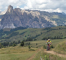
Now it is time for the second session in riding technique on the easy Campo Longo mountain path, on which only a few very high steps interrupt the otherwise perfect “flow“. Then a short section on the road as far as the summit where the next fantastic descent begins. Steep but fantastic to ride. It leaves the road to the pass for a narrow path leading to Arabba.
From Arabba a cable car catapults the bikers up 900m in altitude difference to the Porta Vescovo. The Marmolada is immediately opposite. The view of the glaciated peak is magnificent. Far below the Fedaia reservoir is easily recognisable. The following descent leading to Passo Pordoi captivates at first with its stunning view of the Sella mountain range. Further down it branches out onto a single trail on which experts in riding technique can run riot. The fun ends shortly before the summit. The last 100m of altitude difference are on the pass road.
Directly below Sas de Pordoi, which, by the way, a venturesome cable car from the Passo Pordoi makes accessible for hikers, the next fantastic descent to the Sellaronda begins. 850 varied metres of altitude difference demand yet again full concentration from the meanwhile somewhat tired bikers. There is also still a tricky trail passage directly below Lupo Bianco. Then you roll along relaxed to Canazei in the Fassa valley and over a meadow path on to Campitello.
The cable car is available for the last 1,000m of altitude difference. An enormous cabin takes the mountain bikers, often in the company of hang gliders, to the Col Rodella above the Sellajoch. Once you have arrived up there, the Langkofel offers a magical view. The following section of the tour through the stony town will certainly be shared in the season and on fine weekends with many other hikers and bikers. That does not matter because here you should ride slowly anyway and marvel at the stony witnesses of several centuries of rock-slides of the Langkofel in its various forms.
The following descent begins with a super trail in the shade of the Langkofel. You could continue this descent, but the Rifugio Comici (mountain cabin) is located one and a half kilometres further on on the edge of the trail, a refreshment stop that bikers find difficult to ride past. You may find it difficult to believe, but you can eat excellently in this stunningly located mountain cabin. It remains a secret from where the innkeeper gets the fresh fish for which he is, among other things, highly renowned. In any case, in accordance with all the rules of the culinary art, gourmets can let themselves be pampered here.
It is good that the rest of the way to Wolkenstein is now almost only downhill because a full stomach adds speed to the journey down to the valley. But take care! This varied descent branches off into an easily-overlooked track that you are guaranteed to rush past if you do not look closely at the road book or GPS equipment (waymarker 127).
Somewhat surprisingly, you climb yet again uphill 50m in altitude before La Selva, then however you roll along relaxed and happy back to the starting point of the tour in Wolkenstein.
| |
 |
| |
Variations
1. Extension via Val Duron (Duron valley): The tour is decidedly more demanding, but scenically still more impressive if the last part is combined with the tour into Val Duron. At the valley station in Campitello (waymarker 107) do not take the cable car to the Col Rodella, but from here follow the tour into Val Duron (waymarkers 47-91). At waymarker 136 you again join the tour described here (+22km, +950m of altitude difference).
2. From the Sellajoch straight to Wolkenstein: if it is late or the weather is no longer suitable, you can take a very attractive descent from the stony town via Plan de Gralba to Wolkenstein. At the car park of the cable car to Langkofelscharte at waymarker 114 go straight ahead and follow in the opposite direction the tour “Sellajoch und steinerne Stadt” as far as Plan de Gralba (waymarkers 23- 11). Branch off left to Plan, after 100m bear right on to the ski piste to Wolkenstein. After 1.3km you reach the main road where you turn sharp right. After 60m you join the tour “Sellajoch und steinerne Stadt” at the Casa Alpina at waymarker 7 again that you follow in the opposite direction, after turning sharp left, to your starting point in Wolkenstein. |
| |
|
| |
TOUR INFORMATION
Tour information |
|
% of distance |
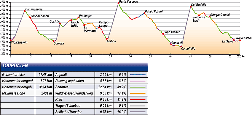
Total distance |
57,48 km |
100 % |
Height variation uphill |
807 Hm |
|
Height variation downhill |
3873 Hm |
|
Maximum altitude |
2484 m |
|
Tarmac |
3,55 km |
| 6,2 % |
 |
|
Tarmac cycle path |
4,87 km |
8,5 %
|
 |
|
Gravel |
22,54 km |
| 39,2 % |
 |
|
Hiking trail |
9,85 km |
17,1 %
|
 |
|
Single track |
6,86 km |
11,9 %
|
 |
|
Carrying / pushing |
0,06 km |
0,1 %
|
 |
|
Cable car / transfer |
9,73 km |
16,9 %
|
 |
|
|
| |
|
|
Riding times |
Riding time without pauses |
Riding time at 10 km/h |
5 hrs 45 min |
Riding time at 12 km/h |
4 hrs 47 min |
Riding time at 14 km/h |
4 hrs 06 min |
Riding time at 16 km/h |
3 hrs 36 min |
Riding time at 18 km/h |
3 hrs 12 min |
Riding time at 20 km/h |
2 hrs 52 min |
| |
|
| |
|
| |
|
| |
|
| |
|
|
|
| |
|
Physical condition |
|
|
Overall condition |
3,5 |
|
Total height variation |
3,0 |
|
Total distance |
4,0 |
|
Maximum altitude |
4,0 |
|
|
|
Riding technique |
|
|
Overall riding technique |
3,1 |
|
Surface |
3,4 |
|
Average climb gradient Ø |
2,0 |
|
Average descent gradient Ø |
4,0 |
|
|
|
| |
|
Tour evaluation |
|
|
Overall difficulty |
3,4 |
|
Climb difficulty |
2,9 |
|
Descent difficulty |
4,3 |
|
|
|
Emotional experience |
|
|
Panorama |
5,0 |
|
Riding fun |
5,0 |
|
| |
|
|
|
|
| |
|
GETTING THERE AND STARTING POINT
Getting there
Take Brenner motorway A22, coming from the north via Innsbruck-Brenner, or from the south via Verona-Bozen.
The best motorway exit is Klausen/Gröden. From there in about 20 minutes you can reach St Ulrich and a few kilometres further on St. Christina and Wolkenstein on a clearly signposted mountain road.
Starting point
The tourism association is located on the left about 500 m after you enter the village of Wolkenstein.
Parking is available at the the beginning of the village centre of Wolkenstein. Turn left before Nives Platz and then immediately left again into the Nives car park.
The tour begins at the tourism association Wolkenstein.
|
| |
ROADBOOK
No |
km |
Next |
Hm |
Sym |
Location |
Direction |
Route |
Time 22 km/h |
Time 10 km/h |
1 |
0,00 |
0,17 |
1557 |
|
Tourist information office in Selva |
Straight on uphill |
|
00:00 |
00:00 |
2 |
0,17 |
0,09 |
1566 |
|
Bottom of Ciampinoi lift |
Straight on |
|
00:00 |
00:01 |
3 |
0,25 |
0,04 |
1566 |
|
Hotel Krone |
Bear right onto main road |
|
00:00 |
00:01 |
4 |
0,29 |
0,09 |
1567 |
|
Junction Str. Dantercepies |
Sharp left Langental/ Vallunga |
|
00:00 |
00:01 |
5 |
0,38 |
0,16 |
1577 |
|
Hotel Sun Valley |
Straight on |
|
00:01 |
00:02 |
6 |
0,54 |
0,37 |
1593 |
|
Junction to Langental |
Straight on to Dantercepies |
|
00:01 |
00:03 |
7 |
0,91 |
0,04 |
1635 |
|
Junction towards bottom of Dantercepies lift |
Right uphill towards Dantercepies |
|
00:02 |
00:05 |
8 |
0,95 |
2,56 |
1642 |
|
Bottom of Dantercepies lift |
Right and take cable car |
|
00:02 |
00:05 |
9 |
3,51 |
0,04 |
2291 |
|
Top of Dantercepies lift |
Bear right to Grödner Joch/Passo Gardena |
|
00:09 |
00:21 |
10 |
3,54 |
0,27 |
2284 |
|
Junction near top of Dantercepies lift |
Straight on following main hiking trail |
|
00:09 |
00:21 |
11 |
3,81 |
0,16 |
2266 |
|
Junction to bend |
Sharp right following main hiking trail |
|
00:10 |
00:22 |
12 |
3,98 |
0,54 |
2243 |
|
Junction towards top of lift |
Sharp right following main hiking trail |
|
00:10 |
00:23 |
13 |
4,52 |
0,08 |
2162 |
|
Fork |
Bear left |
|
00:12 |
00:27 |
14 |
4,59 |
0,19 |
2155 |
|
Junction |
Sharp right |
|
00:12 |
00:27 |
15 |
4,78 |
0,11 |
2131 |
|
Intersection |
Right |
|
00:13 |
00:28 |
16 |
4,89 |
0,07 |
2121 |
|
Near Restaurant Frara |
Left/right through subway |
|
00:13 |
00:29 |
17 |
4,96 |
0,92 |
2107 |
|
Intersection with ski piste |
Left downhill |
|
00:13 |
00:29 |
18 |
5,88 |
0,09 |
1961 |
|
Small lake, car park |
Straight on across car park |
|
00:16 |
00:35 |
19 |
5,97 |
0,89 |
1958 |
|
Signpost, marker stone |
Bear right to Corvara |
|
00:16 |
00:35 |
20 |
6,85 |
0,36 |
1779 |
|
Junction with hiking trail |
Bear right to Corvara |
|
00:18 |
00:41 |
21 |
7,21 |
0,79 |
1719 |
|
Rest area |
Straight on to Corvara |
|
00:19 |
00:43 |
22 |
8,00 |
0,54 |
1692 |
|
Crossroads |
Bear left to Corvara |
|
00:21 |
00:48 |
23 |
8,54 |
0,67 |
1651 |
|
Junction towards Colfosco, water source |
Straight on |
|
00:23 |
00:51 |
24 |
9,22 |
0,52 |
1593 |
|
Bridge over stream |
Bear right to Corvara |
|
00:25 |
00:55 |
25 |
9,74 |
0,81 |
1561 |
|
Camping |
Bear right to Corvara |
|
00:26 |
00:58 |
26 |
10,55 |
0,22 |
1553 |
|
Junction below drag lift |
Straight on over piste |
|
00:28 |
01:03 |
27 |
10,77 |
0,07 |
1541 |
|
Hotel Arkadia, near bottom of Boé lift |
Left |
|
00:29 |
01:04 |
28 |
10,84 |
0,06 |
1539 |
|
Snack Bar Corf |
Right for pedestrians |
|
00:29 |
01:05 |
29 |
10,90 |
0,04 |
1537 |
|
Crossroads |
Straight on across stream |
|
00:29 |
01:05 |
30 |
10,94 |
0,12 |
1536 |
|
Crossroads |
Straight on towards church |
|
00:29 |
01:05 |
31 |
11,06 |
0,13 |
1540 |
|
Villa Tony |
Right uphill |
|
00:30 |
01:06 |
32 |
11,19 |
0,18 |
1548 |
|
Piccolornaz |
Left into car park (barrier) |
|
00:30 |
01:07 |
33 |
11,37 |
1,01 |
1565 |
|
Bottom of Col Alto lift |
Take cable car |
|
00:31 |
01:08 |
34 |
12,38 |
0,12 |
1979 |
|
Top of Col Alto lift |
Straight on |
|
00:33 |
01:14 |
35 |
12,50 |
0,33 |
1959 |
|
Junction to Hotel Col Alto |
Sharp right to Pralongia, Piz Sorega |
|
00:34 |
01:14 |
36 |
12,83 |
0,37 |
1913 |
|
Crossroads |
Left to Hotel Dolomiti |
|
00:34 |
01:16 |
37 |
13,20 |
1,27 |
1898 |
|
Bottom of chair lift |
Take chair lift |
|
00:35 |
01:19 |
38 |
14,47 |
0,05 |
2021 |
|
Top of chair lift |
Right to Piz Sorega |
|
00:39 |
01:26 |
39 |
14,52 |
0,12 |
2028 |
|
Restaurant "I Tabla" |
Bear left to Bioch Hut, Pralongia |
|
00:39 |
01:27 |
40 |
14,64 |
0,07 |
2026 |
|
Steps |
Straight on |
|
00:39 |
01:27 |
41 |
14,70 |
0,49 |
2045 |
|
End of steps |
Right (take path on left) |
|
00:40 |
01:28 |
42 |
15,20 |
0,04 |
2070 |
|
Top of chair lift |
Bear left |
|
00:41 |
01:31 |
43 |
15,24 |
0,12 |
2069 |
|
Bioch Hut |
Straight on to Pralongia |
|
00:41 |
01:31 |
44 |
15,36 |
1,10 |
2058 |
|
Junction |
Straight on |
|
00:41 |
01:32 |
45 |
16,46 |
0,53 |
2066 |
|
Junction |
Right to Pralongia (take path over meadow) |
|
00:44 |
01:38 |
46 |
16,99 |
0,02 |
2129 |
|
Pralongia Hut |
Straight on uphill (right of the chapel) |
|
00:46 |
01:41 |
47 |
17,01 |
0,04 |
2133 |
|
Junction by chapel |
Right towards chairlift |
|
00:46 |
01:42 |
48 |
17,05 |
0,10 |
2136 |
|
Chairlift |
Straight on uphill |
|
00:46 |
01:42 |
49 |
17,15 |
0,31 |
2130 |
|
Junction before drag lift |
Straight on |
|
00:46 |
01:42 |
50 |
17,46 |
0,96 |
2092 |
|
Crossroads |
Left to La Marmotta |
|
00:47 |
01:44 |
51 |
18,42 |
2,04 |
1938 |
|
La Marmotta Hut |
Straight on to Campo Longo |
|
00:50 |
01:50 |
52 |
20,47 |
0,65 |
1973 |
|
Junction to Hotel Monte Cherz |
Bear right to Campo Longo |
|
00:55 |
02:02 |
53 |
21,11 |
0,29 |
1886 |
|
Junction to Planac |
Straight on |
|
00:57 |
02:06 |
54 |
21,40 |
0,05 |
1851 |
|
Intersection with gravel road |
Straight on downhill |
|
00:58 |
02:08 |
55 |
21,45 |
0,63 |
1848 |
|
Intersection with main road, car park |
Bear left |
|
00:58 |
02:08 |
56 |
22,08 |
0,18 |
1876 |
|
Campo Longo |
Straight on downhill |
|
01:00 |
02:12 |
57 |
22,26 |
1,14 |
1875 |
|
|
Bear right onto hiking trail parallel to road over pass |
|
01:00 |
02:13 |
58 |
23,40 |
0,29 |
1702 |
|
Junction to Plan Boe |
Straight on to Arabba |
|
01:03 |
02:20 |
59 |
23,69 |
0,22 |
1649 |
|
Junction to Plan Boe |
Straight on downhill |
|
01:04 |
02:22 |
60 |
23,91 |
0,14 |
1603 |
|
Intersection Casa Arnica |
Bear right |
|
01:05 |
02:23 |
61 |
24,05 |
0,06 |
1592 |
|
Ristorante Posta |
Bear right into “Zona traffico limitato” |
|
01:05 |
02:24 |
62 |
24,12 |
0,10 |
1593 |
|
Church at Arabba |
Bear right uphill |
|
01:05 |
02:24 |
63 |
24,21 |
0,13 |
1598 |
|
Casa Cantoniva |
Bear left to cable car |
|
01:06 |
02:25 |
64 |
24,34 |
0,11 |
1599 |
|
Bridge over stream |
Bear left along stream |
|
01:06 |
02:26 |
65 |
24,44 |
2,58 |
1603 |
|
Bottom of Porta Vescovo lift |
Take cable car |
|
01:06 |
02:26 |
66 |
27,03 |
0,55 |
2484 |
|
Top of Porta Vescovo lift |
Sharp right downhill |
|
01:13 |
02:42 |
67 |
27,58 |
0,11 |
2362 |
|
Junction to Arabba/Passo Pordoi |
Sharp left Passo Pordoi |
|
01:15 |
02:45 |
68 |
27,69 |
0,08 |
2354 |
|
Junction with gravel road |
Straight on |
|
01:15 |
02:46 |
69 |
27,77 |
1,95 |
2340 |
|
Junction with gravel road |
Straight on |
|
01:15 |
02:46 |
70 |
29,72 |
2,23 |
2130 |
|
Junction |
Straight on Passo Pordoi 680 |
|
01:21 |
02:58 |
71 |
31,95 |
1,19 |
2134 |
|
Intersection with road over pass near Ristoro Lezuo |
Straight on uphill |
|
01:27 |
03:11 |
72 |
33,14 |
0,40 |
2203 |
|
Signpost “Benvenuti a Belluno” |
Straight on uphill |
|
01:30 |
03:18 |
73 |
33,54 |
0,15 |
2238 |
|
Passo Pordoi |
Straight on |
|
01:31 |
03:21 |
74 |
33,69 |
0,94 |
2221 |
|
Sass Pordoi cable car |
Bear left Pecol/ Canazei |
|
01:31 |
03:22 |
75 |
34,63 |
0,02 |
2121 |
|
Reservoir |
Sharp right Pecol/ Canazei |
|
01:34 |
03:27 |
76 |
34,65 |
0,08 |
2119 |
|
Benches |
Bear left downhill to bend |
|
01:34 |
03:27 |
77 |
34,73 |
0,18 |
2107 |
|
Hotel Gonzaga, bend 19 |
Bear right downhill on main road |
|
01:34 |
03:28 |
78 |
34,91 |
0,10 |
2099 |
|
Signpost “Al Lago – zum See” |
Sharp right |
|
01:35 |
03:29 |
79 |
35,01 |
0,62 |
2099 |
|
End of tarmac |
Straight on |
|
01:35 |
03:30 |
80 |
35,63 |
0,28 |
2031 |
|
Near bend in road over pass |
Straight on |
|
01:37 |
03:33 |
81 |
35,91 |
0,63 |
1993 |
|
Junction |
Straight on |
|
01:37 |
03:35 |
82 |
36,53 |
0,12 |
1880 |
|
Junction to bend |
Left |
|
01:39 |
03:39 |
83 |
36,66 |
0,05 |
1853 |
|
Ruined house |
Right |
|
01:39 |
03:39 |
84 |
36,71 |
0,05 |
1850 |
|
Junction to Passo Pordoi, Pecol |
Straight on |
|
01:40 |
03:40 |
85 |
36,76 |
0,50 |
1850 |
|
Intersection with road over pass, Ristorante Monti Pallidi |
Sharp left back onto road over pass Canazei |
|
01:40 |
03:40 |
86 |
37,26 |
0,16 |
1813 |
|
Intersection with road over pass towards Pordoi, bend 14 |
Bear right downhill Canazei |
|
01:41 |
03:43 |
87 |
37,42 |
0,07 |
1802 |
|
Junction with forest trail |
Sharp right |
|
01:42 |
03:44 |
88 |
37,49 |
0,21 |
1800 |
|
Signpost “Località Roa” |
Sharp left to Lupo Bianco |
|
01:42 |
03:44 |
89 |
37,70 |
0,20 |
1784 |
|
Crossing with road over pass |
Straight on to Lupo Bianco |
|
01:42 |
03:46 |
90 |
37,90 |
0,13 |
1742 |
|
Large meadow |
Straight on to Lupo Bianco |
|
01:43 |
03:47 |
91 |
38,02 |
0,05 |
1724 |
|
Intersection |
Bear left |
|
01:43 |
03:48 |
92 |
38,07 |
0,12 |
1724 |
|
Plan de Frataces 1725 |
Bear right |
|
01:43 |
03:48 |
93 |
38,19 |
0,14 |
1720 |
|
Lupo Bianco (lake) |
Bear left Canazei 655 |
|
01:44 |
03:49 |
94 |
38,34 |
0,20 |
1713 |
|
Junction |
Straight on |
|
01:44 |
03:50 |
95 |
38,54 |
0,18 |
1662 |
|
Bend 8 |
Stay on trail |
|
01:45 |
03:51 |
96 |
38,72 |
1,33 |
1654 |
|
Intersection with gravel road |
Sharp right downhill |
|
01:45 |
03:52 |
97 |
40,04 |
0,24 |
1494 |
|
Bridge |
Bear left over bridge |
|
01:49 |
04:00 |
98 |
40,28 |
0,11 |
1452 |
|
Church of Canazei |
Sharp right |
|
01:49 |
04:01 |
99 |
40,39 |
0,15 |
1448 |
|
Bridge |
Left after bridge into Strada Roma |
|
01:50 |
04:02 |
100 |
40,54 |
0,29 |
1439 |
|
Crossing with main road |
Straight on along Strada Roma |
|
01:50 |
04:03 |
101 |
40,82 |
0,18 |
1425 |
|
Hotel Genzianella |
Sharp left at Campo Sportivo (sports ground) |
|
01:51 |
04:04 |
102 |
41,00 |
0,17 |
1426 |
|
Intersection with Strèda de Cerenà |
Right |
|
01:51 |
04:06 |
103 |
41,17 |
0,85 |
1420 |
|
Cardo Residence |
Bear right across meadow |
|
01:52 |
04:07 |
104 |
42,02 |
0,54 |
1423 |
|
Beginning of gravel path |
Straight on |
|
01:54 |
04:12 |
105 |
42,56 |
0,20 |
1402 |
|
Car park for tennis courts |
Straight on |
|
01:56 |
04:15 |
106 |
42,76 |
0,06 |
1405 |
|
Car park at bottom of Col Rodella lift |
Right towards cable car |
|
01:56 |
04:16 |
107 |
42,82 |
0,10 |
1400 |
|
Bottom of Col Rodella lift |
Take cable car |
|
01:56 |
04:16 |
108 |
45,13 |
0,14 |
2399 |
|
Top of Col Rodella lift |
Straight on |
|
02:03 |
04:30 |
109 |
45,27 |
0,51 |
2400 |
|
Rifugio des Alpes |
Straight on Passo Sella |
|
02:03 |
04:31 |
110 |
45,78 |
0,47 |
2313 |
|
Crossroads |
Right Passo Sella |
|
02:04 |
04:34 |
111 |
46,25 |
0,70 |
2243 |
|
Junction to Rodella Hut |
Straight on Passo Sella |
|
02:06 |
04:37 |
112 |
46,94 |
0,16 |
2212 |
|
Crossroads (to Salei Hut) |
Bear left at meadow |
|
02:08 |
04:41 |
113 |
47,11 |
0,11 |
2190 |
|
Junction near chapel |
Straight on |
|
02:08 |
04:42 |
114 |
47,22 |
0,06 |
2181 |
|
Car park at bottom of Langkofelscharte gorge lift |
Sharp left towards bottom lift |
|
02:08 |
04:43 |
115 |
47,27 |
1,27 |
2183 |
|
Bottom of Langkofelscharte lift, beginning of City of Stone |
Straight on |
|
02:08 |
04:43 |
116 |
48,54 |
0,06 |
2235 |
|
Beginning of pushing section (uphill) |
Straight on |
|
02:12 |
04:51 |
117 |
48,60 |
0,53 |
2226 |
|
End of pushing section (uphill) |
Straight on |
|
02:12 |
04:51 |
118 |
49,13 |
0,74 |
2148 |
|
Intersection |
Bear left (marked red-white) |
|
02:14 |
04:54 |
119 |
49,87 |
0,02 |
2152 |
|
Junction |
Straight on |
|
02:16 |
04:59 |
120 |
49,89 |
0,11 |
2153 |
|
Comici Hut |
Straight on to Wolkenstein/Selva |
|
02:16 |
04:59 |
121 |
50,01 |
0,47 |
2137 |
|
Junction to Ciampinoi |
Bear right to Wolkenstein/Selva |
|
02:16 |
05:00 |
122 |
50,47 |
0,52 |
2077 |
|
Junction downhill |
Left downhill across meadow |
|
02:17 |
05:02 |
123 |
51,00 |
0,34 |
2008 |
|
Intersection with hiking trail |
Bear right downhill |
|
02:19 |
05:05 |
124 |
51,34 |
0,06 |
1965 |
|
Junction 22c (gate) |
Straight on |
|
02:20 |
05:08 |
125 |
51,40 |
0,19 |
1963 |
|
Junction |
Bear right La Selva 22 |
|
02:20 |
05:08 |
126 |
51,59 |
1,21 |
1947 |
|
Crossing (towards Cason Hut) |
Straight on |
|
02:20 |
05:09 |
127 |
52,80 |
0,13 |
1750 |
|
Inconspicuous junction with hiking trail |
Sharp right towards bridge over stream |
|
02:24 |
05:16 |
128 |
52,94 |
0,23 |
1742 |
|
Intersection with hiking trail |
Bear left downhill 23 |
|
02:24 |
05:17 |
129 |
53,16 |
0,45 |
1720 |
|
Junction |
Bear right |
|
02:24 |
05:18 |
130 |
53,61 |
0,50 |
1743 |
|
Cross ski piste (near camelback) |
Straight on |
|
02:26 |
05:21 |
131 |
54,11 |
1,19 |
1764 |
|
Intersection with gravel road |
Left Wolkenstein |
|
02:27 |
05:24 |
132 |
55,30 |
0,32 |
1615 |
|
Junction to bend |
Bear right uphill |
|
02:30 |
05:31 |
133 |
55,61 |
0,10 |
1598 |
|
Hotel Pozzamanigoni |
Straight on |
|
02:31 |
05:33 |
134 |
55,71 |
0,19 |
1589 |
|
Junction with gravel road |
Straight on downhill |
|
02:31 |
05:34 |
135 |
55,90 |
0,02 |
1568 |
|
Junction with hiking trail |
Straight on downhill |
|
02:32 |
05:35 |
136 |
55,92 |
0,51 |
1567 |
|
Transformer, bus stop La Selva |
Sharp right |
|
02:32 |
05:35 |
137 |
56,43 |
0,18 |
1535 |
|
Junction with hiking trail |
Straight on following road |
|
02:33 |
05:38 |
138 |
56,61 |
0,43 |
1541 |
|
Junction with path signpost 30 |
Straight on |
|
02:34 |
05:39 |
139 |
57,04 |
0,08 |
1540 |
|
House of Culture |
Bear right along stream |
|
02:35 |
05:42 |
140 |
57,12 |
0,20 |
1543 |
|
Fire station |
Straight on |
|
02:35 |
05:42 |
141 |
57,32 |
0,06 |
1548 |
|
Beginning of tarmac |
Straight on |
|
02:36 |
05:43 |
142 |
57,39 |
0,05 |
1550 |
|
Casa Elisabetha |
Sharp left over bridge over stream |
|
02:36 |
05:44 |
143 |
57,44 |
0,05 |
1554 |
|
Café Mozart |
Sharp right uphill to main road |
|
02:36 |
05:44 |
144 |
57,49 |
0,00 |
1557 |
|
Tourist information office in Wolkenstein/Selva |
End of tour |
|
02:36 |
05:44 |
EXPLANATION OF EVALUATION FACTORS, SURFACE AND SLOPE
Explanation of evaluation factors
• Overall difficulty based on climb difficulty (60%) and descent difficulty (40%)
• Climb difficulty based on total distance uphill (30%), overall height variation uphill (30%), surface uphill (10%), average slope uphill (25%), highest altitude reached (5%).
• Descent difficulty consists of total distance downhill (10%), overall height variation downhill (10%), surface downhill (50%), average slope downhill (30%).
• Physical condition based on total distance (40%), with overall height variation (50%) and highest altitude reached (10%).
• Riding technique based on surface (50%), with average slope uphill (30%) and average slope downhill (20%).
• Writer’s subjective evaluation of panorama and riding fun.
Explanation of surface and slope |
|
|
|
A = Tarmac road |
|
steep uphill |
from + 15% |
R = Tarmac cycle path |
|
uphill |
up to + 14% |
S = Gravel |
|
level |
ca. +/- 4% |
W = Hiking trail |
|
downhill |
up to - 19% |
P = Path, Single Trail |
|
steep downhill |
from - 20% |
T = Carrying / pushing |
|
|
|
X = Cable car / transfer |
|
|
|
Route: the percentages indicate the average climb (+) or the average descent (-) to the next waymarker. |
DOWNLOADS
| |
 |
 |
 |
 |
CHARACTERISTICS |
ALTITUDE PROFILE |
ROADBOOK |
MAP |
|
| |
It is recommended to discover the "Clockwise tour of the Sellaronda" accompanied by an official national mountain bike guide (www.sellaronda-mtb.com).
More infos at the MTB Schools Val Gardena |
